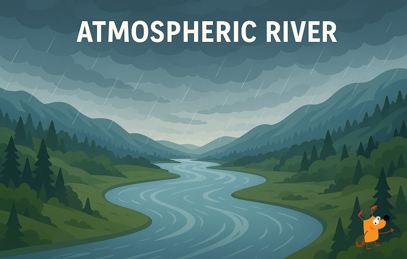
Atmospheric River: The Sky Rivers
You’ve likely heard the term “atmospheric river” increasingly used in weather forecasts, especially if you live on the West Coast of the US. But what is an atmospheric river (AR)? Far from just heavy rain, these powerful weather systems are crucial, complex, and sometimes dangerous phenomena. Let’s dive deep into the world of these “rivers in the sky.”
What is an Atmospheric River??
Imagine a narrow corridor in the atmosphere, concentrated like a river, transporting immense amounts of water vapor from the tropics towards the poles. That’s the essence of an atmospheric river. While invisible to the naked eye, satellites can detect them as long, flowing plumes of moisture stretching thousands of miles across the ocean.
An atmospheric river is a narrow corridor of concentrated water vapor in the atmosphere that transports moisture from tropical and subtropical regions to higher latitudes. These phenomena act like “rivers in the sky,” carrying water vapor equivalent to 15 times the flow of the Colorado River. The atmospheric river definition describes these features as long, narrow bands of enhanced water vapor transport that can extend thousands of miles across the ocean.
When atmospheric rivers make landfall, they release enormous amounts of precipitation as the moisture-laden air encounters mountains or other geographic features that force the air upward, cooling it and causing condensation. This process can produce intense rainfall or snowfall over extended periods.
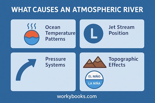
What Causes an Atmospheric River? How Do They Form?
Several atmospheric and oceanic factors contribute to atmospheric river formation:
- Ocean Temperature Patterns: Warm sea surface temperatures provide the energy and moisture necessary for atmospheric river development.
- Pressure Systems: Low-pressure areas create the wind patterns that organize and transport moisture in narrow corridors.
- Jet Stream Position: The location and strength of the jet stream influence where atmospheric rivers develop and travel.
- Topographic Effects: Mountain ranges and other geographic features can enhance, redirect, or weaken atmospheric rivers.
- Climate Patterns: Larger climate oscillations like El Niño and La Niña affect the frequency and intensity of atmospheric river events.
How Rare is an Atmospheric River?
Atmospheric rivers themselves are not rare. On average, there are typically 3-5 atmospheric river events occurring somewhere around the globe at any given time.
They are a constant feature of Earth’s global water cycle, always present somewhere over the oceans. In fact, studies suggest that although ARs only cover about 10% of the Earth’s surface at any given time, they are responsible for moving over 90% of the moisture transported from the tropics towards the poles.
For specific regions like California, atmospheric rivers occur several times each winter season, with the state typically experiencing 5-15 significant events annually.However, truly extreme, “ARkStorm” level events are much rarer, occurring perhaps once every 100-200 years, but carry catastrophic potential.
Why is “Rain” Now Called an Atmospheric River?
The term “atmospheric river” reflects a deeper scientific understanding:
- Specific Phenomenon: It pinpoints the source and mechanism of the moisture – a long, narrow river of vapor originating over the ocean.
- Scale and Impact: It conveys the immense scale and potential impact of these events, distinguishing them from ordinary rain showers or widespread storms.
- Forecasting Precision: Meteorologists can now better identify, track, and predict the intensity of these specific moisture plumes using satellites and models, allowing for more accurate warnings. Calling it an AR provides more context than just “rain.”
Where do atmospheric rivers occur? .
Atmospheric rivers are most common along the western coasts of continents, where they interact with mountainous terrain. Key regions include:
- Atmospheric River California: The state experiences some of the most significant atmospheric river events in North America. These systems regularly impact the Sierra Nevada mountains and coastal ranges, bringing both beneficial water resources and flood risks.
- Atmospheric River Washington: The Pacific Northwest frequently encounters atmospheric rivers, with the Cascade Mountains enhancing precipitation through orographic lifting.
- Atmospheric River Bay Area: The San Francisco Bay Area often experiences atmospheric rivers that can bring heavy rainfall to urban areas and surrounding hills.
- Atmospheric River Seattle: Seattle and the broader Puget Sound region regularly experience atmospheric river events, particularly during winter months. These can bring several inches of rain over short periods, leading to urban flooding and river flooding in surrounding watersheds.
- West Coast of South America (Chile)
- Western Europe (especially the UK, Portugal, France)
- Western Africa
- New Zealand
- Southwestern Australia
What is an Atmospheric River Storm?
This term refers to the entire weather system associated with the landfall of an AR. It includes:
- The intense rainfall/snowfall.
- Strong, often damaging winds (especially near any associated cold front).
- Potential for thunderstorms embedded within the system.
- The significant hydrological impacts: flooding, landslides, rapid rises in rivers and streams.
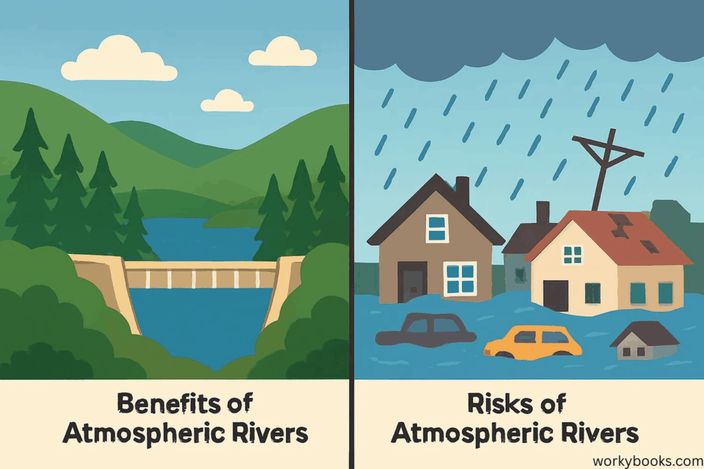
What Are the Effects of Atmospheric Rivers?
The effects are profound and double-edged:
- Vital Water Supply: ARs are crucial for water resources. In regions like California, they can replenish 30-50% of the annual precipitation in just a few events, filling reservoirs and building the Sierra snowpack – the state’s largest “reservoir.”
- Beneficial Snowpack: Mountain snowpack from ARs provides essential meltwater for rivers, agriculture, and ecosystems throughout the dry summer months.
- Flooding & Landslides: The primary danger. Intense, prolonged rainfall saturates soils, overwhelms drainage, and causes rivers to flood rapidly. Steep terrain becomes susceptible to destructive debris flows and landslides.
- Wind Damage: Associated strong winds can down trees and power lines, causing widespread outages.
- Travel Disruption: Major impacts on road, air, and rail travel due to flooding, low visibility, and debris.
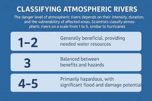
Are Atmospheric Rivers Dangerous?
The danger level of atmospheric rivers depends on their intensity, duration, and the vulnerability of affected areas. Scientists classify atmospheric rivers on a scale from 1 to 5, similar to hurricanes:
- Category 1-2: Generally beneficial, providing needed water resources
- Category 3: Balanced between benefits and hazards
- Category 4-5: Primarily hazardous, with significant flood and damage potential
What makes an this river storm particularly dangerous is the combination of heavy precipitation rates, long duration, and terrain effects that can produce rapid water accumulation.
Is it Safe to Drive in an Atmospheric River?
Driving during an intense river is strongly discouraged and often unsafe. Key hazards include:
- Severe Hydroplaning: Deep water on roads causes loss of traction.
- Flooded Roadways: It takes surprisingly little water (6-12 inches) to sweep away a vehicle. NEVER drive through flooded roads. “Turn Around Don’t Drown!”
- Reduced Visibility: Heavy rain and spray drastically lower visibility.
- Debris on Roads: Fallen branches, rocks, mudslides.
- Road Closures and Washouts: Roads can be damaged or disappear entirely.
- Strong Winds: Pushing vehicles, especially high-profile ones.
The Role of Technology in Atmospheric River Forecasting
Modern atmospheric river maps and forecasting tools help scientists and emergency managers predict these events with increasing accuracy. Satellite imagery, computer models, and real-time observations combine to provide detailed information about atmospheric river intensity, track, and potential impacts.
These tools are essential for water resource management, flood forecasting, and emergency preparedness across affected regions.
Meteorologists use specialized atmospheric river maps to track these events. These maps combine:
- Satellite imagery showing water vapor plumes.
- Computer model forecasts predicting moisture transport intensity (measured in kg/m/s).
- Radar and rain gauge data during landfall. (Search “NOAA atmospheric river outlook” or “CW3E AR forecast” for current examples).
How Can We Prepare for Atmospheric Rivers?
Preparation strategies include:
Before the Event:
- Monitor atmospheric river maps and forecasts from the National Weather Service
- Clear gutters and drainage systems around your property
- Secure outdoor items that could become projectiles
- Stock emergency supplies including water, food, flashlights, and batteries
- Review evacuation routes if you live in flood-prone areas
During the Event:
- Stay indoors when possible
- Avoid unnecessary travel
- Monitor local emergency broadcasts
- Never attempt to cross flooded roads
- Report flooding or emergency situations to authorities
After the Event:
- Check for property damage
- Be cautious of unstable ground and potential landslide areas
- Avoid standing water that may be contaminated
The Takeaway
Atmospheric rivers are fundamental components of our planet’s climate system, acting as massive conveyors of moisture. While they deliver essential precipitation to many regions they also pose significant hazards.
As climate change continues to affect global weather patterns, atmospheric rivers may become more intense in some regions, making public education and preparedness even more important. By staying informed about atmospheric river forecasts and understanding their potential impacts, individuals and communities can prepare for their impacts and make informed decisions about water resource management and emergency preparedness.
Interactive Learning Resources from workybooks:
- Atmospheric Rivers Explained for Kids – Interactive educational page with activities, quizzes, visual content, and FAQ section designed for young learners
- What is an Atmospheric River – Reading Comprehension – Auto-graded reading passage and quiz for grades 3-8, perfect for teachers, parents, and homeschoolers
Related Posts
Understanding Extreme Weather Events and Climate Change

Geometry in Daily Life: Why It Matters in 3rd Grade and Beyond