Reading PassagePremium

Fjord Estuary Example

Interactive passage with audio narration, comprehension questions, and printable PDF.

No ratings yet|
1
Grades 3–6ElaReadingScienceEnglish · SpanishInteractive · Printable
Just this resource
$1.50
One-time purchase
Best value
Unlock everything
$49.99$24.99/yr
50% off until Sept 15 — 10,000+ resources
Renews at $49.99/year.

By completing this purchase you agree to our Terms of Use and Privacy Policy. Your subscription renews automatically until you cancel. You can cancel anytime from your account settings. All sales are final and non-refundable. Digital content is available for download in your account immediately upon purchase.

Unlock above to use these actions

What's included

Reading passage
Audio narration
Comprehension quiz
Writing activity
Glossary & flashcards
Differentiated version
Spanish translation

Fjord Estuary Example preview and details

About this printable Fjord Estuary Example science reading passage, NGSS-aligned (Grades 3-6)

This audio -aligned reading passage introduces students to fjord estuaries, deep narrow valleys carved by glaciers and later flooded by seawater. The passage highlights Sognefjord in Norway, one of the world’s largest fjord estuaries, and fjords in Alaska such as Kenai Fjords. Students learn about key characteristics, including their great depth, steep sides, and glacial sills that affect water circulation. It explains why oxygen levels are low in deep waters but why upper waters are rich in life, supporting whales, seabirds, and fish. The passage also explores human uses such as fishing, safe harbors, and tourism, while noting environmental challenges from pollution and climate change. With engaging fun facts and audio integration for accessibility, this passage connects NGSS Life Science: Structure and Function to real-world glacial estuaries.
Written by Workybooks TeamPublished by Workybooks
Preview

Sample passage and quiz from Fjord Estuary Example

Reading passage and comprehension quiz preview

Fjord Estuary Example
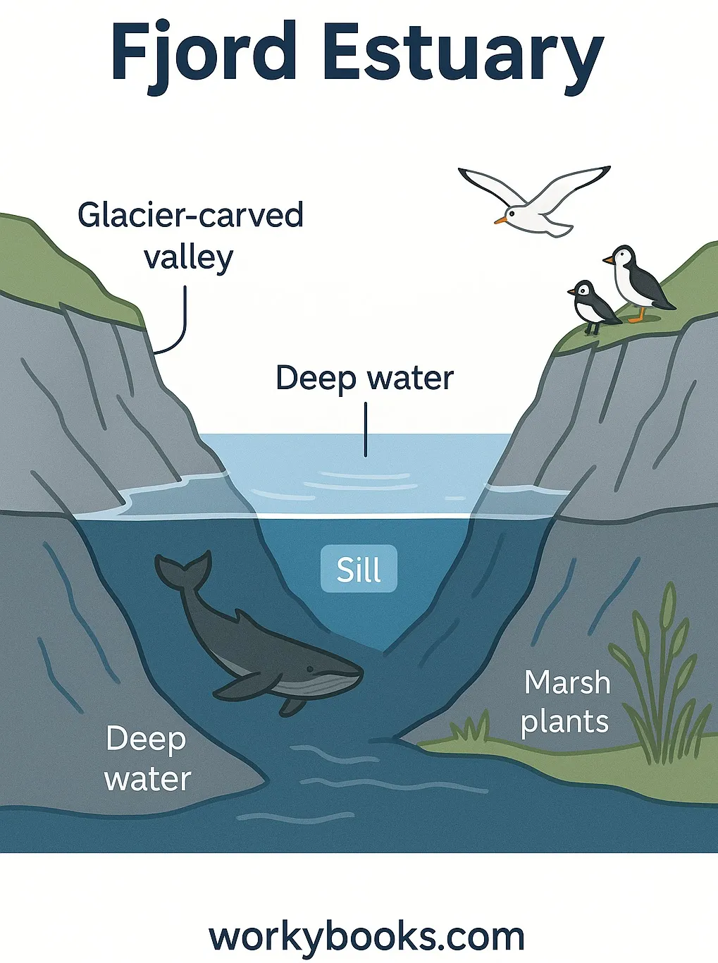
Fjord Estuary

Fjord Estuary Example

A fjord is a long, deep, narrow body of water that stretches far inland. Fjords are special kinds of estuaries found in places like Norway. These amazing landforms were created thousands of years ago during the ice age.

Back then, giant sheets of ice called glaciers covered much of the Earth. A glacier is a huge, slow-moving river of ice. As glaciers moved, their heavy ice scraped the land like a giant bulldozer. This powerful scraping carved out deep, U-shaped valleys in the land. These valleys are much deeper and steeper than regular river valleys, which are usually V-shaped.

When the ice age ended, the glaciers melted. The ocean rushed in and filled the deep valleys with salt water, creating fjords. Norway has some of the most famous fjords in the world, with tall, steep cliffs rising from deep blue water. Some fjords are over 4,000 feet deep—deeper than many lakes!

Fjords are home to many animals. Seals rest on rocks or swim in the cold water. Whales come to fjords to eat fish. Salmon swim up fjords from the sea to lay their eggs. Seabirds nest on the high cliffs, safe from most predators.

Fjords are not only found in Norway. You can also find them in Alaska, New Zealand, and Chile. They all share the same shape and history—carved by glaciers, filled by the ocean, and now home to amazing wildlife.

Think of a glacier as a giant ice cube slowly sliding down a mountain. As it moves, it digs a deep trench. When the ice melts, the ocean pours in and makes a fjord.

Interesting Fact: Some fjords are so deep that their bottoms are below sea level, and they can be more than 100 miles long!

Comprehension quiz (8 questions)

1. What is a fjord?

A deep, narrow ocean valley
A mountain peak
A flat, sandy beach
A desert landform

2. What shaped fjords long ago?

Glaciers
Wind
Volcanoes
Rain

3. Where are Norway's fjords found?

In deep valleys
On volcanoes
In deserts
On plains

4. Why do salmon swim up fjords?

To lay eggs
To sleep
To drink water
To stay warm

5. How is a fjord different from a river valley?

It is U-shaped and deeper
It is drier
It is flat
It is above sea level

6. What happens when glaciers melt?

Ocean fills the valley
Mountains form
Deserts appear
Ice grows thicker

7. Some fjords are over 4,000 feet deep. True or false?

True
False

8. What is a glacier?

A slow-moving river of ice
A type of bird
A deep lake
A kind of fish
Who it's for

Perfect for the way you teach

Teachers
  • Build comprehension skills
  • Auto-graded quiz
  • Differentiated reading
Parents
  • Read together at home
  • Improve fluency
  • Quiet reading time
Homeschoolers
  • Reading curriculum support
  • Independent practice
  • Track Lexile growth
Topics

Reviews & Ratings

No reviews yet. Be the first to share your experience!

More reading you might love

20 more
Passage
Tools and Technology in Earth Science - reading educational content

Tools and Technology in Earth Science

Reading Passage · MS-ESS2-2+4

$1.50
Passage
Rivers and Water Features - reading educational content

Rivers and Water Features

Reading Passage · NGSS 4-ESS2-2+1

$1.50
Passage
Earth's Land and Water - reading educational content

Earth's Land and Water

Reading Passage · NGSS 4-ESS2-2+1

$1.50
Passage
My Planet Earth - reading educational content

My Planet Earth

Reading Passage · FL.SS.2.G.1.1+1

Free
Passage
Distribution of Water on Earth - reading educational content

Distribution of Water on Earth

Reading Passage · MS-ESS2-4+1

$1.50
Passage
What Is Space Weather and How Does It Affect the Earth? - reading educational content

What Is Space Weather and How Does It Affect the Earth?

Reading Passage · MS-ESS2-2

$1.50
Passage
What Is The Difference Between Glacial Ice And Regular Ice? - reading educational content

What Is The Difference Between Glacial Ice And Regular Ice?

Reading Passage

$1.50
Passage
How Satellites Help Scientists Study Earth From Space - reading educational content

How Satellites Help Scientists Study Earth From Space

Reading Passage · MS-ESS2-1

$1.50
Passage
Surface Water: Rivers, Lakes, and Wetlands - reading educational content

Surface Water: Rivers, Lakes, and Wetlands

Reading Passage · MS-ESS2-4

$1.50
Passage
How GPS Technology Map Earth's Surface - reading educational content

How GPS Technology Map Earth's Surface

Reading Passage · MS-ESS2-1

$1.50
Passage
Scientific Inquiry in Earth Science - reading educational content

Scientific Inquiry in Earth Science

Reading Passage · MS-ESS1-4+3

$1.50
Passage
What Is Earth Science? - reading educational content

What Is Earth Science?

Reading Passage · MS-ESS1+3

$1.50
Passage
Earth: Our Home in Space - reading educational content

Earth: Our Home in Space

Reading Passage

$1.50
Passage
Introduction to Earth Science - reading educational content

Introduction to Earth Science

Reading Passage · MS-ESS3-1

$1.50
Passage
How Is Water Distributed on Earth - reading educational content

How Is Water Distributed on Earth

Reading Passage · MS-ESS2-4

$1.50
Passage
Collaboration Between Earth Science Branches - reading educational content

Collaboration Between Earth Science Branches

Reading Passage · MS-ESS2-1

$1.50
Passage
How Feedback Loops Shape Earth - reading educational content

How Feedback Loops Shape Earth

Reading Passage · MS-ESS2-1

$1.50
Passage
Earthquake Patterns on Earth - reading educational content

Earthquake Patterns on Earth

Reading Passage · NGSS 4-ESS2-2

$1.50
Passage
When Was The Last Ice Age - reading educational content

When Was The Last Ice Age

Reading Passage · MS-ESS2-2

$1.50
Passage
Facts About Earth - reading educational content

Facts About Earth

Reading Passage

$1.50
Copyright © 2026 Workybooks. Made with ♥ in California.