Workybooks

Stratigraphic Columns: Decoding Earth’s Geological Layers — Reading Comprehension

Grades
5
6
7
8
Standards
MS-ESS2-2
MS-ESS1-4
RST.6-8.7
PRINT+DIGITAL RESOURCE
This learning resource is available in interactive and printable formats. The interactive worksshet can be played online and assigned to students. The Printable PDF version can be downloaded and printed for completion by hand.
ABOUT THIS READER
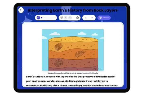
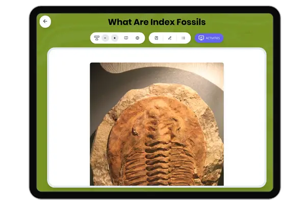
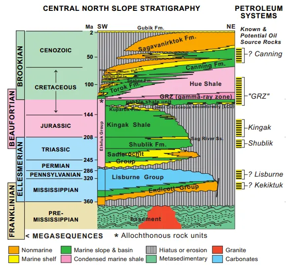
This passage explains stratigraphic columns as tools for interpreting geological history. Aligned with NGSS MS-ESS2-2 and MS-ESS1-4, it analyzes real-world examples: the Permian Basin's oil-bearing formations (Delaware Group, Bone Spring), Jurassic Rodessa Limestone reservoirs, and Louisiana's Miocene deltaic deposits. The text meets CCSS.ELA-LITERACY.RST.6-8.7 for visual data interpretation, with applications in hydrocarbon exploration and paleoenvironment reconstruction. Written for middle school earth science, it emphasizes unconformities, lithologic symbols, and fossil zones while connecting to energy industry practices.
Publisher: Workybooks
|
Written by:Workybooks Team
|
Illustrated by:

A stratigraphic column is a visual representation of rock layers in a specific region, showing their sequence, thickness, and composition. These columns help geologists interpret depositional environments, tectonic events, and fossil records through geological time.


Key Features of Stratigraphic Columns

  1. Layer Order: Displays oldest (bottom) to youngest (top) formations following the Law of Superposition.
  2. Lithology: Symbols represent rock types (e.g., sandstone, shale, limestone).
  3. Fossil Zones: Marks biozones where specific fossils appear.
  4. Unconformities: Gaps in the geologic record caused by erosion or non-deposition.


Notable Examples

  1. Permian Basin Stratigraphic Column (Texas/New Mexico)

○       Includes the Delaware Mountain Group (sandstone/shale) and Bone Spring Formation(limestone).

○       Hosts prolific oil reservoirs like the Spraberry Trend.

  1. Rodessa Limestone Column (Louisiana/East Texas)

○       A Jurassic-aged carbonate formation.

○       Known for porous limestone units that trap oil and gas.

  1. Louisiana Gulf Coast Column

○       Features thick Miocene deltaic deposits (sandstone/shale).

○       Records ancient sea-level changes and sediment influx from the Mississippi River.


Stratigraphic columns are vital for energy exploration, paleoclimate studies, and understanding Earth’s history. For example, the Permian Basin column reveals ancient reef systems, while Louisiana’s columns guide drilling for hydrocarbons.


Fun Fact: The oldest rock layers on Earth contain fossils of microscopic bacteria dating back 3.5 billion years, but the most dramatic explosion of complex life appears suddenly in layers from about 540 million years ago—a period called the Cambrian Explosion.

What does a stratigraphic column display?

Only volcanic rocksSequence of rock layers from oldest to youngestFuture tectonic eventsAtmospheric gas composition

Which principle ensures older rocks are at the bottom?

Cross-cutting relationshipsLaw of SuperpositionUniformitarianismPlate tectonics

What marks gaps in the geologic record?

FossilsUnconformitiesIgneous intrusionsMetamorphic zones

Where is the Permian Basin located?

CaliforniaTexas/New MexicoFloridaAlaska

What resource is associated with the Rodessa Limestone?

GroundwaterCoalOil and gasDiamond

Which feature dominates Louisiana’s Gulf Coast column?

Glacial depositsMiocene deltaic sedimentsBasalt flowsPermian reefs

How do stratigraphic columns aid oil exploration?

By predicting earthquakesIdentifying porous rock layersMeasuring atmospheric CO₂Tracking wildlife migration

What Jurassic formation is mentioned?

Bone SpringRodessa LimestoneDelaware GroupSpraberry Trend

Related Content

interactive | printable worksheet on CCSS MS-ESS2-1,MS-ESS2-2,RST.6-8.4 - Talus Slopes: Formation and Features - thumbnail
Talus Slopes: Formation and Features
This earth science passage explains talus slope formation through mechanical weathering processes, aligning with NGSS MS...
MS-ESS2-1MS-ESS2-2RST.6-8.4
interactive | printable worksheet on CCSS MS-ESS2-1,MS-ESS2-2,RST.6-8.3 - Frost Wedging: How Ice Splits Rock - thumbnail
Frost Wedging: How Ice Splits Rock
This passage explains frost wedging as a mechanical weathering process. Aligned with NGSS MS-ESS2-1 (Earth’s systems) a...
MS-ESS2-1MS-ESS2-2RST.6-8.3
interactive | printable worksheet on CCSS MS-ESS2-1,MS-ESS2-2,RST.6-8.4 - Chemical Weathering: The Breakdown of Rocks Through Chemical Reactions - thumbnail
Chemical Weathering: The Breakdown of Rocks Through Chemical Reactions
This passage explains chemical weathering processes, aligned with NGSS MS-ESS2-1 (Earth’s systems) and ESS2-2 (surface ...
MS-ESS2-1MS-ESS2-2RST.6-8.4
interactive | printable worksheet on CCSS MS-ESS2-1,LS2.C,RST.6-8.7 - Limestone Caves: Nature’s Underground Wonders - thumbnail
Limestone Caves: Nature’s Underground Wonders
This passage explains limestone cave formation through carbonation, aligned with NGSS MS-ESS2-1 (Earth’s systems) and L...
MS-ESS2-1LS2.CRST.6-8.7
interactive | printable worksheet on CCSS MS-ESS3-2,MS-ESS2-2,RST.6-8.3 - Volcanic Eruptions: Causes, Types, and Key Features - thumbnail
Volcanic Eruptions: Causes, Types, and Key Features
This science passage explains volcanic eruptions, aligned with NGSS MS-ESS3-2 (natural hazards) and ESS2-2 (Earth’s syst...
MS-ESS3-2MS-ESS2-2RST.6-8.3
Copyright © 2025 Workybooks. Made with ♥ in California.