
Epicenter - Definition, Examples, Quiz, FAQ, Trivia
Discover where earthquakes begin and how scientists locate them
What is an Epicenter?
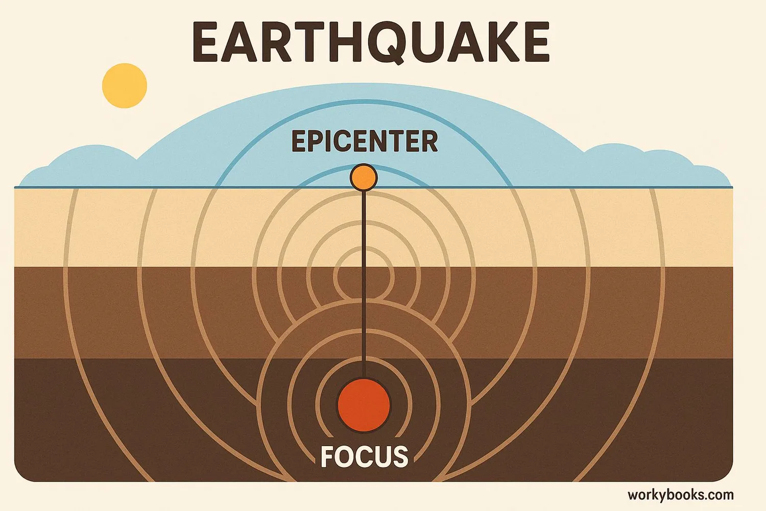
An epicenter is the point on Earth's surface directly above where an earthquake begins deep underground. Think of it like this: if you drop a rock in a pond, the epicenter would be the exact spot where the rock hit the water.
The actual starting point of the earthquake is called the focus or hypocenter. This is where the rocks first break along a fault line deep within the Earth. The epicenter is the point on the surface directly above this focus.
Did You Know?
The word "epicenter" comes from Greek words meaning "upon the center." It's the surface center of earthquake activity!
How Epicenters are Located
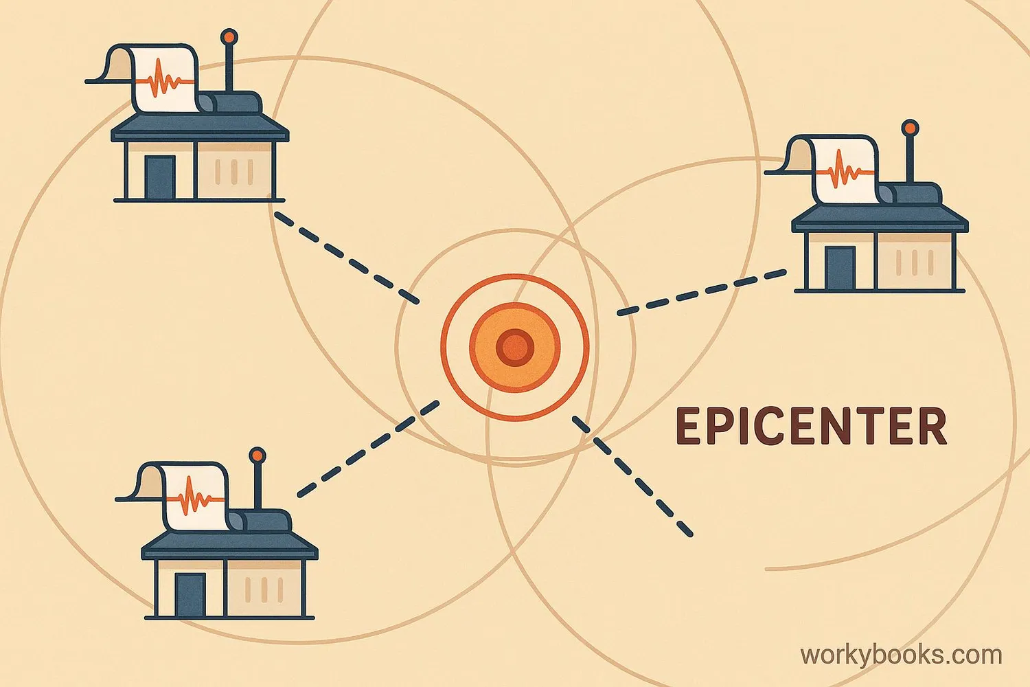
Scientists use a method called triangulation to locate earthquake epicenters. Here's how it works:
Seismograph Detection
Special instruments called seismographs detect earthquake waves at different locations
Wave Arrival Times
Scientists note when different types of waves arrive at each station
Distance Calculation
The time difference between wave types helps calculate distance to epicenter
Triangulation
Circles are drawn around at least three stations; where they intersect is the epicenter
This process is similar to how you might locate something by using information from different friends who saw or heard it from different locations. The more seismograph stations that detect the earthquake, the more accurately scientists can pinpoint the epicenter.
Modern Technology
Today, computers help scientists locate epicenters within minutes of an earthquake occurring, allowing for faster warnings to potentially affected areas.
Why Epicenters Matter
Knowing the location of earthquake epicenters is crucial for several important reasons:
Damage Assessment
The strongest shaking usually occurs near the epicenter, helping officials determine where aid is most needed
Fault Mapping
Epicenter locations help scientists map unknown fault lines beneath the surface
Early Warnings
Quick epicenter location allows for warnings to areas that might experience shaking next
By tracking epicenters over time, scientists can also:
• Identify areas at higher risk for future earthquakes
• Understand how tectonic plates are moving and interacting
• Study patterns that might help predict future seismic activity
• Design better building codes for earthquake-prone regions
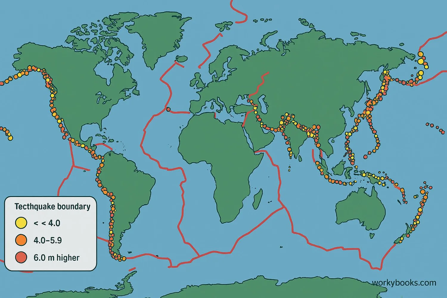
The study of epicenters has helped us understand that most earthquakes occur along the boundaries of Earth's tectonic plates, in areas known as the "Ring of Fire" around the Pacific Ocean.
Epicenter Quiz
Test your knowledge about earthquake epicenters with this quiz. Answer all 5 questions to see how much you've learned.
Frequently Asked Questions
Here are answers to some common questions about earthquake epicenters:
Earthquake Trivia
Discover some fascinating facts about earthquakes and epicenters:
Global Network
There are more than 10,000 seismograph stations around the world constantly monitoring for earthquakes. This global network helps scientists quickly locate epicenters anywhere on Earth.
Historical Detection
The first scientific determination of an earthquake epicenter was for the 1880 earthquake in Croatia, using data from multiple seismograph stations across Europe.
Ring of Fire
About 90% of all earthquakes occur along the "Ring of Fire," a path around the Pacific Ocean basin where many tectonic plates meet and interact.
Satellite Technology
Modern scientists now use GPS and satellite data along with seismographs to precisely locate epicenters and measure how much the ground moved during an earthquake.
