Barriers to Reaching California
Interactive passage with audio narration, comprehension questions, and printable PDF.
What's included
Barriers to Reaching California preview and details
About this printable Barriers to Reaching California reading passage (Grades 3-5)
Sample passage and quiz from Barriers to Reaching California
Reading passage and comprehension quiz preview
Barriers to Reaching California
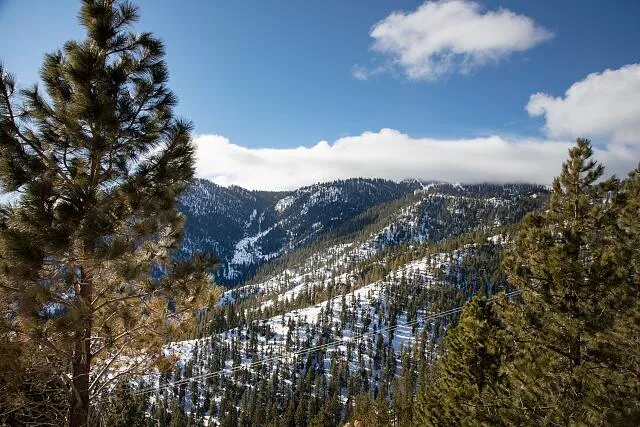
"Scene in the Sierra Nevada Mountains, near the Nevada side of Lake Tahoe" by Highsmith, Carol M., 1946- / Library of Congress.
California was once very hard to reach for people living in other parts of America. The state was surrounded by huge natural obstacles that made travel dangerous and slow. These barriers kept California isolated for hundreds of years.
One major barrier was the Sierra Nevada mountains. This tall, rocky mountain range runs along the eastern edge of California. The mountains are covered in deep snow during the winter. Even in summer, the steep slopes and thick forests made travel difficult. Early travelers risked getting lost, running out of food, or freezing during snowstorms.
To the east of the Sierra Nevada, there are wide and dry deserts. These deserts, like the Mojave Desert, are very hot and have little water. People who tried to cross these deserts had to bring all their supplies with them. Many struggled to find water or shelter. Sometimes, their wagons got stuck in the sand.
The Pacific Ocean forms California’s western border. For explorers and settlers coming from the east, this huge ocean was another obstacle. Ships had to travel long distances from other countries. Storms and rough waves often damaged boats. The journey by sea could take months and was risky.
California was also surrounded by hostile territories. Sometimes, Native American groups or other settlers did not want strangers passing through their land. This made travel even more dangerous.
Because of these natural barriers, California stayed geographically isolated from most of America for a long time. Only a few brave explorers, like Jedediah Smith and John C. Frémont, managed to cross the mountains and deserts. It was not until the 1800s, when new trails and railroads were built, that more people could reach California safely and quickly.
These obstacles shaped California’s early history. The state developed its own culture and resources. When gold was discovered in 1848, many people took on the challenge of crossing deserts and mountains to get there. Their journeys showed courage and determination.
Interesting Fact: The Sierra Nevada means “snowy mountains” in Spanish because of its high, snowy peaks.
Comprehension quiz (8 questions)
1. What mountain range blocks California?
2. Which desert is east of California?
3. What was discovered in California in 1848?
4. How did the Pacific Ocean affect travel?
5. Why was California isolated?
6. Who were Jedediah Smith and John C. Frémont?
7. California had no natural obstacles. True or false?
8. What does 'hostile' mean?
Perfect for the way you teach
- Build comprehension skills
- Auto-graded quiz
- Differentiated reading
- Read together at home
- Improve fluency
- Quiet reading time
- Reading curriculum support
- Independent practice
- Track Lexile growth