
Nimbostratus Clouds - Definition, Examples, Quiz, FAQ, Trivia
Understanding Rain Clouds and Their Role in Weather Patterns
What are Nimbostratus Clouds?
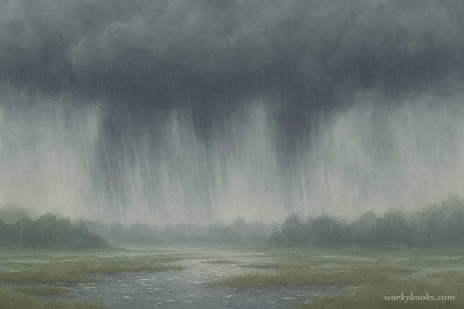
Nimbostratus clouds are thick, dark gray cloud layers that cover the sky like a blanket and produce steady, continuous precipitation. The name comes from Latin: "nimbo" means rain, and "stratus" means layer.
These are the classic rain clouds that bring hours of drizzle, rain, or snow. Unlike dramatic thunderstorm clouds, nimbostratus clouds create gray, overcast days with persistent precipitation that can last for many hours.
Science Fact!
Nimbostratus clouds are so thick that they often block out sunlight completely, making the day appear much darker than it actually is, even at midday!
How Nimbostratus Clouds Form
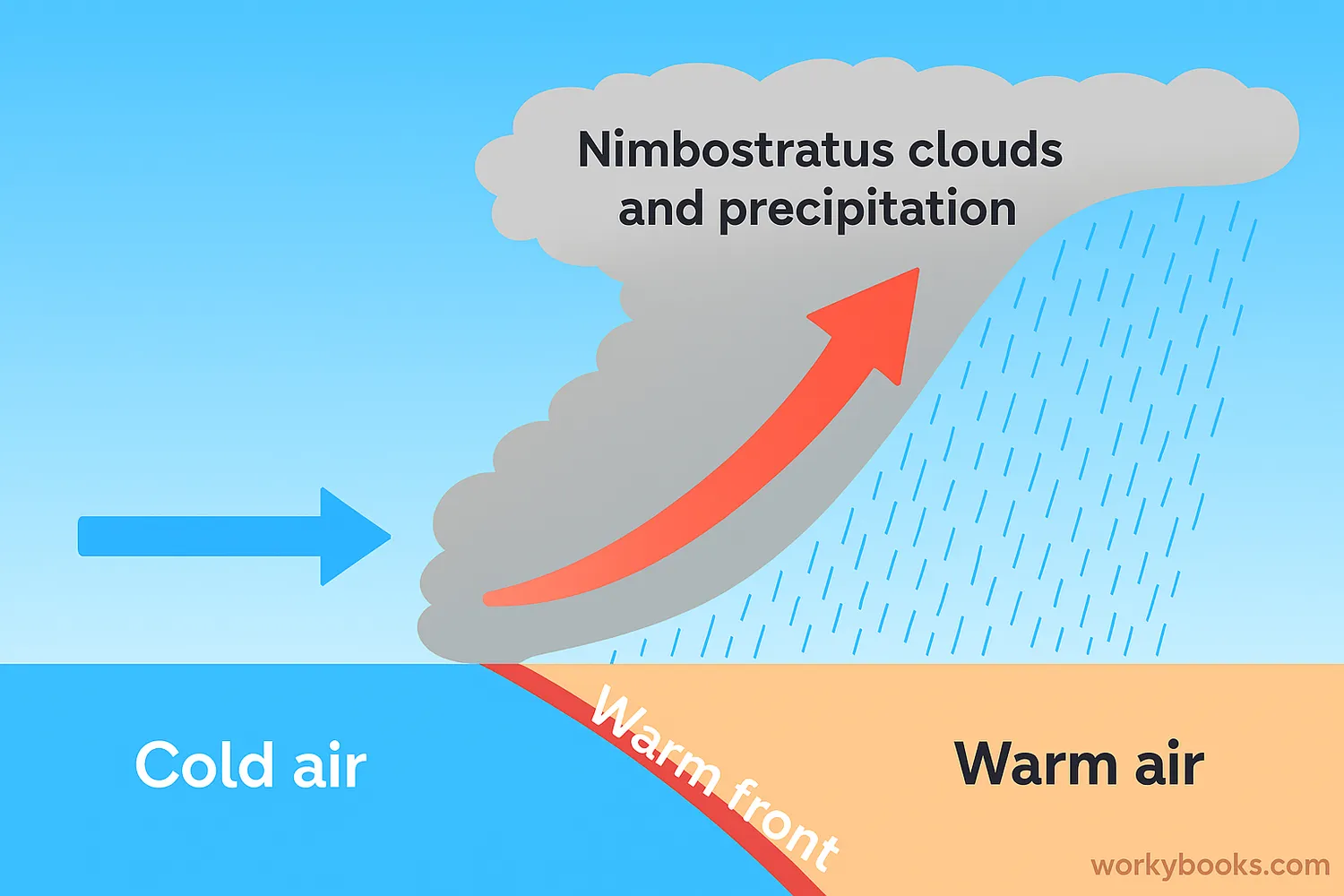
Nimbostratus clouds form through a process called large-scale lifting of air masses. Here's how it works:
Air Mass Meeting
A warm, moist air mass meets a colder, denser air mass
Lifting Occurs
The warm air is forced to rise over the colder air
Cooling and Condensation
As the air rises, it cools and water vapor condenses
Cloud Formation
Cloud droplets form and grow into a thick layer
Precipitation Begins
Droplets combine and fall as steady rain or snow
This process often happens along weather fronts, especially warm fronts where warm air gradually rides up over colder air. The slow, steady lifting creates the widespread, layered cloud structure typical of nimbostratus clouds.
Characteristics of Nimbostratus Clouds

Nimbostratus clouds have several distinctive features that help identify them:
Appearance
Thick, dark gray layer that covers the sky completely
Altitude
Low to middle level clouds (usually 2,000-10,000 feet)
Texture
Uniform, featureless base without clear edges or shapes
Precipitation
Produces steady, continuous rain, drizzle, or snow
Sun Visibility
Often completely blocks out the sun and moon
Unlike puffy cumulus clouds or dramatic cumulonimbus clouds, nimbostratus clouds don't have distinctive shapes or features. They create a uniform, gray blanket that can make the day feel dark and gloomy, even during daytime hours.
Nimbostratus vs. Stratus Clouds
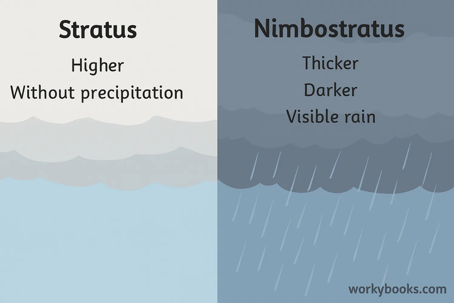
While both nimbostratus and stratus clouds are low, layered clouds, they have important differences:
Thickness
Stratus: Thinner layer, often with visible sun
Nimbostratus: Thicker, blocks sunlight completely
Color
Stratus: Light to medium gray
Nimbostratus: Dark gray to blackish
Precipitation
Stratus: Light drizzle or none
Nimbostratus: Steady rain or snow
Formation
Stratus: From gentle lifting or cooling
Nimbostratus: From large-scale air mass lifting
Think of stratus clouds as the light misty layer and nimbostratus clouds as the heavy rain-producing blanket. Sometimes stratus clouds can thicken and develop into nimbostratus clouds when conditions become right for precipitation.
Observation Tip!
If you can see the sun or moon through the clouds, they're probably stratus clouds. If the clouds are so thick that you can't see the sun at all, they're likely nimbostratus clouds.
Nimbostratus Clouds Quiz
Test your knowledge with this quiz! Answer all 5 questions to see how much you've learned about nimbostratus clouds.
Frequently Asked Questions
Here are answers to some common questions about nimbostratus clouds:
Science Facts About Nimbostratus Clouds
Discover some fascinating facts about nimbostratus clouds and weather phenomena!
Steady Precipitation
Nimbostratus clouds are responsible for most of the steady, widespread precipitation that falls in middle latitudes. Unlike showery precipitation from cumulus clouds, rain from nimbostratus can last for many hours without stopping.
Front Companions
Nimbostratus clouds most commonly form ahead of warm fronts, where warm air is gradually lifted over colder air. This slow lifting process creates the widespread, layered structure perfect for continuous precipitation.
Vertical Extent
While classified as low-level clouds, nimbostratus clouds often have considerable vertical depth, sometimes extending upward into the middle cloud level. This thickness is what allows them to produce significant precipitation.
Weather Predictors
The appearance of nimbostratus clouds often indicates that precipitation is imminent or already occurring. Meteorologists use these clouds to predict extended periods of rainy or snowy weather, sometimes lasting for days.
