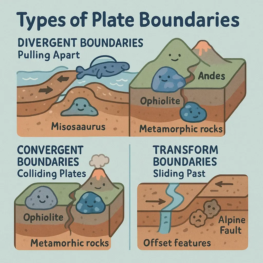
This learning resource is available in interactive and printable formats. The interactive worksheet can be played online and assigned to students. The Printable PDF version can be downloaded and printed for completion by hand.
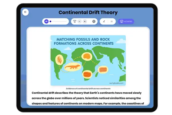
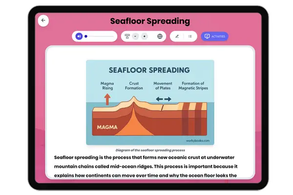
This science passage explores how geologists use rock formations, fossil distributions, and seafloor structures to identify three types of plate boundaries: divergent (mid-ocean ridges with pillow basalts), convergent (subduction zones with ophiolites), and transform (fault lines with offset features). The text highlights key evidence like magnetic stripes in seafloor rocks, marine fossils atop mountains, and matching fossil distributions across continents. Aligned with NGSS MS-ESS2-3 (analyzing rock/fossil data as evidence of plate motions), it demonstrates how scientists reconstruct ancient plate movements through observable phenomena. The passage includes real-world examples like the Mid-Atlantic Ridge, Andes Mountains, and San Andreas Fault, while explaining geological concepts such as subduction, seafloor spreading, and continental drift. Perfect for middle school earth science units covering Earth's systems and plate tectonics, it supports reading informational text standards focusing on key details and evidence-based interpretation.
CONTENT PREVIEW
Expand content preview
Earth's surface is like a giant jigsaw puzzle, with tectonic plates constantly moving and interacting. Geologists piece together clues from rocks, fossils, and seafloor structures to map ancient plate boundaries and understand how our planet has changed over millions of years.
1. Divergent Boundaries: Pulling Apart
Evidence:
● Pillow basalts: Lava that cools rapidly underwater, forming bulbous shapes (common at mid-ocean ridges).
● Magnetic stripes: Symmetrical patterns of magnetic minerals in seafloor rock, recording Earth's magnetic field reversals as new crust forms.
● Fossil clues: Identical freshwater reptile fossils (like Mesosaurus) found in Africa and South America—continents now separated by the Atlantic Ocean.
Example: The Mid-Atlantic Ridge shows young, basaltic rock at the center, aging outward—proof of seafloor spreading.
2. Convergent Boundaries: Colliding Plates
Evidence:
● Ophiolites: Slabs of ancient oceanic crust thrust onto continents (e.g., California's Coast Ranges).
● Metamorphic rocks: High-pressure minerals like blueschist form where plates subduct.
Example: The Andes Mountains contain volcanic rocks and folded sedimentary layers, showing oceanic-continental collision.
3. Transform Boundaries: Sliding Past
Evidence:
● Offset features: Rivers or rock layers abruptly cut by faults (like California's San Andreas).
● Earthquake scars: Pulverized rock ("fault gouge") along shear zones.
Example: The Alpine Fault in New Zealand has shifted rocks 480 km horizontally over 25 million years!
Putting It All Together
By studying:
● Rock ages (youngest at divergent zones, oldest near trenches),
● Fossil distributions (like tropical plant fossils in Arctic rocks),
● Magnetic and seismic data,
scientists reconstruct Earth's "lost" boundaries—like the ancient Tethys Ocean floor now crumpled into the Himalayas
Fun Fact: The same dinosaur species (Plateosaurus) fossils found in Europe and North America prove these continents were once connected!
AnotherFun Fact: Did you know that the Himalayas contain fossilized seashells and shark teeth? These marine fossils, found at the top of Mount Everest, prove that the world's highest mountain range was once the bottom of an ancient ocean! This incredible transformation happened when India crashed into Asia 50 million years ago at a
What type of rock forms when lava cools rapidly underwater at divergent boundaries?
GraniteSandstonePillow basaltMarble
Why are identical freshwater reptile fossils found on different continents?
The reptiles could swim across oceansThe continents were once joined togetherScientists made a mistake in identificationWind carried the fossils
What creates the symmetrical magnetic stripes on the seafloor?
Underwater volcanoesEarth's magnetic field reversing over timeFish swimming in patternsOcean currents
What happens to oceanic crust at convergent boundaries?
It evaporatesIt subducts (sinks) into the mantleIt turns into magma immediatelyIt floats on top of continental crust
What type of boundary would you expect to find offset rivers or rock layers?
Divergent boundaryConvergent boundaryTransform boundarySubduction zone
What kind of fossils would you most likely find on top of the Himalayas?
Desert plantsMarine creaturesPolar bearsDinosaurs
What does the presence of ophiolites on continents suggest?
Ancient seafloor was pushed onto landVolcanoes erupted underwaterEarth's crust is getting thinnerFossils can turn into rocks
How do scientists use rock ages to study plate boundaries?
The youngest rocks are always in the middle of oceansThe oldest rocks are found at divergent boundariesRock ages don't help study plate boundariesAll rocks are the same age
Perfect For:
👩🏫 Teachers
• Reading comprehension practice
• Auto-graded assessments
• Literacy skill development
👨👩👧👦 Parents
• Reading practice at home
• Comprehension improvement
• Educational reading time
🏠 Homeschoolers
• Reading curriculum support
• Independent reading practice
• Progress monitoring
Reading Features:
📖
Reading Passage
Engaging fiction or nonfiction text
❓
Comprehension Quiz
Auto-graded questions
📊
Instant Feedback
Immediate results and scoring
📄
Printable Version
Download for offline reading
🔊
Read Aloud
Voice-over with word highlighting
Reviews & Ratings
No reviews yet. Be the first to share your experience!
Related Content
How Are Metamorphic Rocks Formed?
This science passage explains how metamorphic rocks form through metamorphism, detailing the effects of heat (150°C-1,00...
MS-ESS2-3RI.6.1RI.7.4RI.8.2
How Are Igneous Rocks Formed?
This science passage explains the complete formation process of igneous rocks, covering both intrusive (granite) and ext...
MS-ESS2-3RI.6.1RI.7.4RI.8.2
Intrusive Igneous Rocks: Formation and Features
This passage explains the formation of intrusive igneous rocks through slow cooling of magma beneath Earth's surface. It...
MS-ESS2-3RI.6.1RI.7.4RI.8.2
Obsidian: The Natural Glass Rock
This science reading passage explores obsidian, a volcanic glass that forms when lava cools so rapidly that crystals can...
MS-ESS2-3MS-ESS3-2RST.6-8.4
Type of Mountain Ranges Formed at Convergent Plate Boundaries
This passage explains how Earth's tallest mountain ranges form at convergent plate boundaries. It details two main forma...
MS-ESS2-3RI.6.1RI.7.4RI.8.2
Kīlauea Volcano: Hawaii’s Ever-Changing Landscape
This passage details Kīlauea's volcanic history and status, aligned with NGSS MS-ESS3-2 (natural hazards) and ESS2-3 (Ea...
MS-ESS3-2MS-ESS2-3RST.6-8.2
All About Seismometers
This informational science passage explores seismometers and their role in measuring earthquakes, designed specifically ...
MS-ESS3-2MS-ESS2-3RST.6-8.2
What Is the Difference Between Magma and Lava?
This educational reading passage explains the critical difference between magma and molten rock beneath Earth's surface ...
MS-ESS2-3MS-ESS3-2RST.6-8.4
Sedimentary Rocks
This comprehensive middle school science passage introduces students to sedimentary rocks, detailing their step-by-step ...
MS-ESS2-1MS-ESS2-3MS-ESS3-1
Continental Drift Theory
This middle school science passage explores the Continental Drift Theory, focusing on Alfred Wegener's 1912 hypothesis t...
MS-ESS2-2MS-ESS2-3
Seafloor Spreading
This comprehensive passage introduces middle school students to the concept of seafloor spreading, a fundamental process...
MS-ESS2-2MS-ESS2-3
Reading the Fossil Record
This engaging middle school science passage explores how scientists interpret the fossil record to reveal Earth's histor...