Surface Water: Rivers, Lakes, and Wetlands
Interactive passage with audio narration, comprehension questions, and printable PDF.
What's included
Surface Water: Rivers, Lakes, and Wetlands preview and details
About this printable Surface Water: Rivers, Lakes, and Wetlands science reading passage, NGSS-aligned (Grades 5-8)
Sample passage and quiz from Surface Water: Rivers, Lakes, and Wetlands
Reading passage and comprehension quiz preview
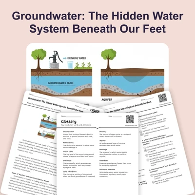
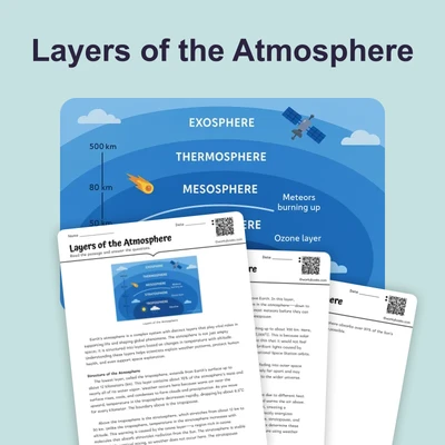
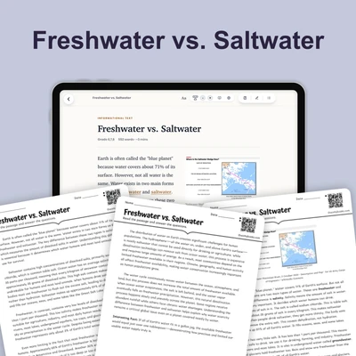
Surface Water: Rivers, Lakes, and Wetlands

Image by GeriArt Source: Pixabay.
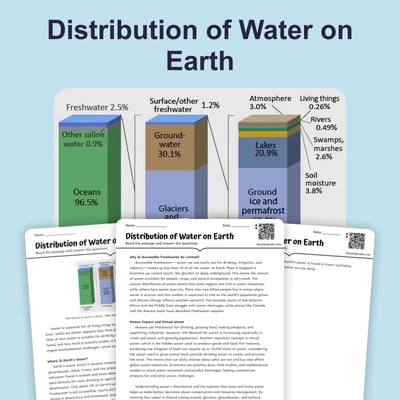
Surface water covers about 0.3% of Earth's freshwater, yet it is essential to life, ecosystems, and human societies. Scientists observe that rivers, lakes, and wetlands are not isolated features—they interact as part of dynamic systems that shape landscapes and support biodiversity. Understanding how these systems work reveals why protecting surface water is critical for our planet's health.
Rivers and Watersheds: Channels of Change
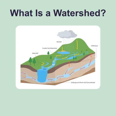
Rivers and streams are moving bodies of water that flow along defined channels. Every river is part of a watershed, which is the area of land where all the water drains into a single river system. The boundaries of watersheds are called divides. For example, the Mississippi River watershed covers over 3 million square kilometers, collecting rain and snowmelt from many states. Rivers erode rock, transport sediment, and deposit nutrients, constantly reshaping the land. Scientists use flow measurements (like cubic meters per second) to monitor river health and predict flooding.
Lakes: Standing Waters with Layers
Lakes form in natural depressions, often created by glaciers, tectonic movements, volcanoes, or dams. Water in lakes does not flow as rapidly as in rivers, allowing for unique zones. The littoral zone is near the shore and full of plant life, the limnetic zone is open, sunlit water, and the profundal zone is deep and dark. These zones support different organisms, from algae to fish. The stability of lakes depends on factors like water inflow, outflow, and temperature layers, which scientists study using temperature profiles and chemical analysis.
Wetlands: Nature's Filters and Nurseries
Wetlands are areas where the land is saturated with water, such as marshes, swamps, and bogs. Marshes are dominated by grasses, swamps by trees, and bogs are acidic with peat buildup. Wetlands are biodiversity hotspots, supporting over 40% of the world’s species in just 6% of land area. They filter pollutants, slow floodwaters, store carbon, and provide nursery habitats for fish and birds. Scientists have documented that wetlands can reduce downstream flooding by up to 60% and remove up to 90% of certain contaminants from water.
Challenges and Connections
Despite their importance, surface water systems face serious threats. Pollution from agriculture and industry, dam construction, drainage for development, and invasion by non-native species disrupt natural balances. Loss of wetlands leads to increased flooding, while polluted rivers and lakes harm wildlife and people. Protecting these systems requires scientific monitoring and coordinated management across entire watersheds, linking human actions to ecosystem health.
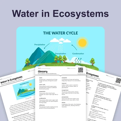
All surface water systems interact with the water cycle, moving water through evaporation, precipitation, and runoff. This interconnectedness means that changes in one part of the system impact the whole. Understanding these mechanisms helps scientists predict environmental changes and design solutions for a sustainable future.
Interesting Fact: The Okavango Delta in Africa is one of the world’s largest inland wetlands, supporting over 1,000 plant species and hundreds of animal species, even though it has no outlet to the sea!
Comprehension quiz (10 questions)
1. What is a watershed?
2. Which lake zone is closest to the shore?
3. What role do wetlands play in the environment?
4. According to the passage, what happens when wetlands are lost?
5. What is the definition of 'biodiversity hotspot' based on the passage?
6. What does the term 'divide' mean in the context of watersheds?
7. Why do scientists measure river flow?
8. Which is NOT mentioned as a cause of surface water threats?
9. True or False: Wetlands can help reduce the impact of floods.
10. True or False: The profundal zone in a lake is well-lit and full of plants.
Perfect for the way you teach
- Build comprehension skills
- Auto-graded quiz
- Differentiated reading
- Read together at home
- Improve fluency
- Quiet reading time
- Reading curriculum support
- Independent practice
- Track Lexile growth