Geography of Ancient Israel
Interactive passage with audio narration, comprehension questions, and printable PDF.
By completing this purchase you agree to our Terms of Use and Privacy Policy. Your subscription renews automatically until you cancel. You can cancel anytime from your account settings. All sales are final and non-refundable. Digital content is available for download in your account immediately upon purchase.
What's included
Part of this bundle

Geography of Ancient Israel preview and details
About this printable Geography of Ancient Israel reading passage (Grades 5-8)
Sample passage and quiz from Geography of Ancient Israel
Reading passage and comprehension quiz preview
Geography of Ancient Israel
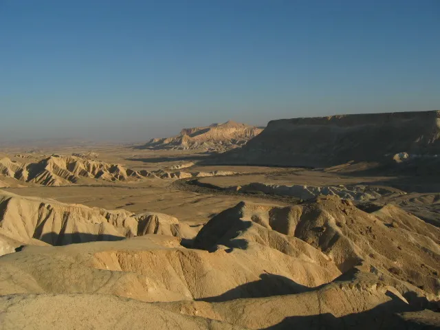
Ancient Israel’s geography included the Negev Desert. / Wikimedia Commons
The region known as Ancient Israel was located at the eastern edge of the Mediterranean Sea, in a land called Canaan. The geography of this area played a critical role in shaping the lives, beliefs, and history of its people. Ancient Israel was bordered by the Mediterranean Sea to the west, deserts to the south and east, and mountains to the north. This land was a crossroads for trade, migration, and the spread of ideas between Africa and Asia.
Ancient Israel’s geography included four main regions: the coastal plain, the central highlands, the Jordan Rift Valley, and the Negev Desert. The coastal plain offered fertile soil and access to the Mediterranean, making it ideal for trade and farming. The central highlands were hilly and rocky, but people built terraces to farm crops like olives and grapes. The Jordan Rift Valley, shaped by tectonic activity, contained the Jordan River—a vital water source for drinking and irrigation. The Negev Desert, hot and dry, covered the south. Although harsh, it provided trade routes to Egypt and Arabia.
Water was both a blessing and a challenge in Ancient Israel. The Jordan River, which flows from Mount Hermon to the Dead Sea, was the main river in the region. It supported agriculture and made the land around it more fertile. Archaeologists have found ancient irrigation channels and storage jars in places such as Megiddo and Jericho, showing how people managed scarce water. Droughts were common, so communities developed cisterns to collect rainwater. The Mediterranean climate brought rainy winters and hot, dry summers, creating alternating periods of abundance and hardship.
The geography also influenced security and culture. The central highlands provided natural defense against invaders. The busy trade routes brought new goods and ideas from Egypt, Mesopotamia, and Phoenicia, making Ancient Israel a center for exchange. Archaeological finds like the Tel Dan Stele (an ancient stone inscription mentioning the "House of David") and pottery shards reveal the influence of neighboring cultures and the daily life of Israelites. Social hierarchy was evident, with farmers, priests, merchants, and rulers each playing roles shaped by the land's resources.
The geography of Ancient Israel changed over time. Early settlements clustered near water sources, but later, as technology improved, people expanded into more challenging areas. Despite environmental difficulties, the people of Ancient Israel adapted to their land, developing unique religious traditions and economic systems. Their connection to the land influenced their stories, laws, and identity for centuries.
Understanding Ancient Israel’s geography helps historians see how environment shapes civilization. The land’s rivers, deserts, and mountains affected everything from daily life to religious beliefs, linking this region to the wider world of ancient civilizations.
Interesting Fact: The Dead Sea, east of Ancient Israel, is over 400 meters below sea level and is the lowest point on the surface of the earth!
Comprehension quiz (8 questions)
1. Which sea bordered Ancient Israel to the west?
2. What was the main river in Ancient Israel?
3. What is the Tel Dan Stele?
4. Why did people build terraces in the highlands?
5. How did geography affect Ancient Israel’s trade?
6. What helped protect Ancient Israel from invaders?
7. The Dead Sea is above sea level. True or false?
8. What does 'hierarchy' mean in this passage?
Perfect for the way you teach
- Build comprehension skills
- Auto-graded quiz
- Differentiated reading
- Read together at home
- Improve fluency
- Quiet reading time
- Reading curriculum support
- Independent practice
- Track Lexile growth