Geography of Ancient China
Interactive passage with audio narration, comprehension questions, and printable PDF.
By completing this purchase you agree to our Terms of Use and Privacy Policy. Your subscription renews automatically until you cancel. You can cancel anytime from your account settings. All sales are final and non-refundable. Digital content is available for download in your account immediately upon purchase.
What's included
Geography of Ancient China preview and details
About this printable Geography of Ancient China reading passage (Grades 5-8)
Sample passage and quiz from Geography of Ancient China
Reading passage and comprehension quiz preview
Geography of Ancient China
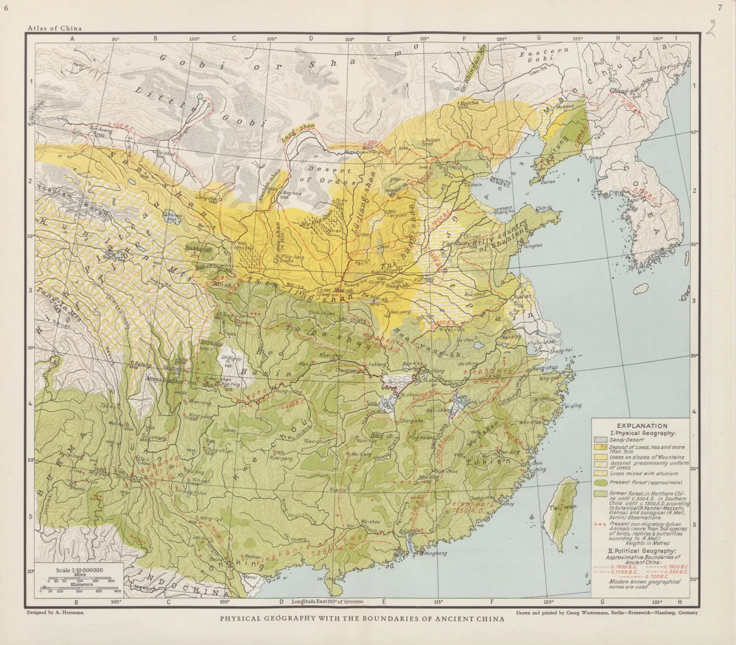
"Physical Geography with the Boundaries of Ancient China" by Albert Herrmann & Georg Westermann /
Source: Wikimedia Commons (Public domain).
Ancient China developed one of the world's earliest and most enduring civilizations because of its unique geography. The landscape of China provided both important advantages and serious challenges that shaped its history and daily life for thousands of years.
The vast land of China is surrounded by natural barriers. To the west, the towering Himalayas and the Taklamakan Desert made travel and invasion difficult. To the north, the Gobi Desert and grasslands also served as protective walls. In the east, the Pacific Ocean separated China from other civilizations. These barriers helped the Chinese people develop a strong sense of cultural identity and relative safety from outside threats. For example, the discovery of ancient city walls in Anyang, the Shang dynasty capital (around 1300 BCE), shows how people combined geography with human-made defenses.
However, these same features isolated China from the rest of the world. Trade and cultural exchange were limited, especially before the opening of the Silk Road during the Han dynasty (206 BCE–220 CE). Despite isolation, the fertile plains along the Yellow River (Huang He) and Yangtze River offered rich soil for agriculture. Farmers used advanced irrigation systems, as shown by archaeological remains, to control flooding and grow crops like millet and rice. The unpredictable flooding of the Yellow River could be both a blessing and a disaster, earning it the name “China’s Sorrow.”
The geography also influenced China’s connections with its neighbors. The Silk Road eventually allowed Chinese goods, such as silk and porcelain, to reach as far as Rome. At the same time, nomadic tribes from the north, like the Xiongnu, sometimes invaded, leading the Chinese to build the Great Wall over centuries for protection. The wall, parts of which date back to the 7th century BCE, is a symbol of how geography shaped military and social strategies.
Over time, the Chinese adapted to their environment, inventing tools and developing government systems to manage both the blessings and dangers of their land. The study of oracle bones, used for divination by the Shang dynasty, reveals how people depended on both nature and spirituality. The impact of geography on Ancient China is still visible today in its culture, language, and traditions. Ancient China’s story shows how people shape and are shaped by the land they inhabit.
This topic connects to the broader theme of how geography influences the rise and development of civilizations worldwide.
Interesting Fact: The Yellow River is sometimes called “the cradle of Chinese civilization” because so many early Chinese societies began along its banks.
Comprehension quiz (8 questions)
1. What protected China to the west?
2. Which river is called 'China's Sorrow'?
3. What did the Silk Road connect?
4. Why did people build the Great Wall?
5. How did natural barriers affect China?
6. What do oracle bones show?
7. The Gobi Desert protected China. True or False?
8. What is 'irrigation'?
Perfect for the way you teach
- Build comprehension skills
- Auto-graded quiz
- Differentiated reading
- Read together at home
- Improve fluency
- Quiet reading time
- Reading curriculum support
- Independent practice
- Track Lexile growth