Reading Passage

Where is the Adriatic Sea

Interactive passage with audio narration, comprehension questions, and printable PDF.

No ratings yet|
2
Grades 3–8ElaReadingScienceEnglish · SpanishInteractive · Printable

What's included

Reading passage
Audio narration
Comprehension quiz
Writing activity
Glossary & flashcards
Differentiated version
Spanish translation

Where is the Adriatic Sea preview and details

About this printable Where is the Adriatic Sea science reading passage, NGSS-aligned (Grades 3-8)

The Adriatic Sea is a semi-enclosed sea of significant geographical and historical importance. This educational passage explores its unique location, separating the Italian and Balkan peninsulas. Students will learn about the contrasting coastlines, with the low Italian shores and the rugged, island-filled Dalmatian coast of Croatia, a result of the geological process of karstification. The text delves into the factors that give the Adriatic a lower salinity, such as freshwater from the Po River, and its impact on the marine ecosystem. It also connects the sea's physical geography to its role as a vital waterway for trade, tourism, and cultural exchange throughout history. Designed for middle school science, this passage aligns with NGSS standards related to Earth's systems and human impact on the environment. It provides a solid foundation for understanding physical geography and the interconnectedness of natural and human systems.
Written by Workybooks TeamPublished by Workybooks
Preview

Sample passage and quiz from Where is the Adriatic Sea

Reading passage and comprehension quiz preview

Where is the Adriatic Sea
adriatic-sea
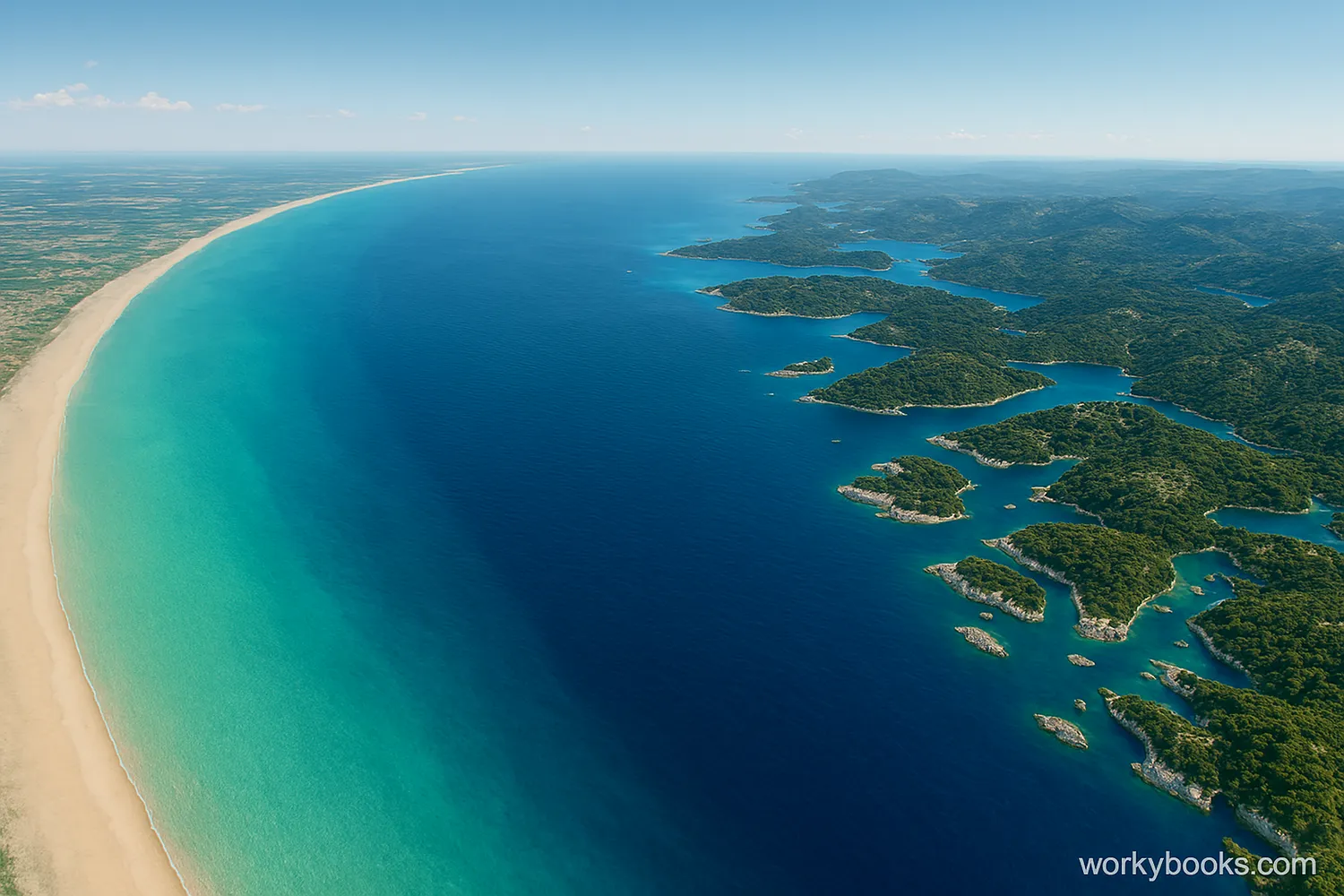
The Adriatic Sea separates the smooth coast of Italy from the rugged, island-dotted coast of the Balkan Peninsula.

The Adriatic Sea is a body of water that is a key component of the larger Mediterranean Sea. It is a semi-enclosed sea that separates two major European peninsulas: the Italian Peninsula to the west and the Balkan Peninsula to the east. This unique geographical position gives the Adriatic its distinct characteristics and historical importance. Its waters stretch approximately 800 kilometers (500 miles) from the Gulf of Venice in the north to the Strait of Otranto in the south, where it connects to the Ionian Sea.


The Adriatic is known for its dramatic contrast in coastlines. The western coast, along Italy, is generally low, straight, and features extensive alluvial plains, including the delta of the Po River. In contrast, the eastern coast, along countries like Croatia, is rugged, rocky, and highly indented with a vast number of islands. This eastern coastline, often called the Dalmatian coast, is a result of a geological process known as karstification, where soluble rock like limestone has been eroded by water over millennia, creating a stunning and complex landscape.


Because of its semi-enclosed nature, the Adriatic Sea has a lower salinity level than the rest of the Mediterranean. This is largely due to the significant freshwater input from rivers, particularly Italy's Po River. These freshwater inflows also contribute a large amount of sediment, making the northern part of the sea shallower and more nutrient-rich. This combination of factors supports a diverse ecosystem, including various species of fish, shellfish, and other marine life that are different from those found in the deeper, saltier parts of the Mediterranean.


The Adriatic Sea has been a vital waterway for trade, travel, and cultural exchange for thousands of years. Cities like Venice and Dubrovnik rose to prominence by controlling its maritime routes. Today, it remains an essential economic resource, with a thriving tourism industry and significant fishing and shipping activities. The sea's clear waters and beautiful coastlines make it a popular destination for tourists from around the world.


Fun Fact: The Adriatic Sea contains over 1,300 islands and islets, with the vast majority of them located along the eastern coast of Croatia.

Comprehension quiz (8 questions)

1. The Adriatic Sea separates which two major European peninsulas?

Scandinavian and Iberian
Italian and Balkan
Greek and Anatolian
Italian and Iberian

2. What is a primary characteristic of the eastern coastline of the Adriatic Sea?

It is low, straight, and sandy.
It is rugged, rocky, and full of islands.
It is dominated by large deltas.
It is a flat, volcanic shore.

3. What process is responsible for the unique and complex landscape of the Dalmatian coast?

Alluvial deposition
Volcanic activity
Karstification
Continental drift

4. Why is the salinity of the Adriatic Sea lower than the rest of the Mediterranean?

It is a deep, cold sea.
It is not connected to the Mediterranean.
It receives significant freshwater from rivers.
Its surface water evaporates quickly.

5. Which of the following best describes the main idea of the reading passage?

The Adriatic Sea is a popular tourist destination.
The Adriatic Sea is a large body of water that connects Europe to Africa.
The Adriatic Sea is a unique semi-enclosed sea with distinct geography and historical importance.
The Adriatic Sea's ecosystem is exactly the same as the rest of the Mediterranean.

6. According to the passage, the Po River has a significant impact on the Adriatic Sea's:

Salinity and sediment levels.
Maximum depth and tidal patterns.
Wind patterns and wave height.
Surrounding political boundaries.

7. Based on the passage, a geologist studying the formation of coastal features would be most interested in which part of the Adriatic Sea?

The flat, sandy beaches of the Italian coast.
The deep southern basin of the sea.
The rocky, indented Dalmatian coast.
The connection point with the Ionian Sea.

8. Which of the following is a true statement about the islands in the Adriatic Sea?

They are all uninhabited.
They are primarily located on the Italian coast.
There are over a thousand of them.
They are all volcanic in origin.
Who it's for

Perfect for the way you teach

Teachers
  • Build comprehension skills
  • Auto-graded quiz
  • Differentiated reading
Parents
  • Read together at home
  • Improve fluency
  • Quiet reading time
Homeschoolers
  • Reading curriculum support
  • Independent practice
  • Track Lexile growth
Topics

Reviews & Ratings

No reviews yet. Be the first to share your experience!

More reading you might love

20 more
Passage
Topographic Maps - reading educational content

Topographic Maps

Reading Passage · MS-ESS2-2+3

$1.50
Passage
Maps and Mapping - reading educational content

Maps and Mapping

Reading Passage · MS-ESS2-2

$1.50
Passage
What Are Topographic Maps - reading educational content

What Are Topographic Maps

Reading Passage · NGSS 4-ESS2-2

$1.50
Passage
How to Read Topographic Maps - reading educational content

How to Read Topographic Maps

Reading Passage · MS-ESS2-1

$1.50
Passage
What Is a Topographic Map? - reading educational content

What Is a Topographic Map?

Reading Passage · FL.SS.2.G.1.1+1

Free
Passage
What Is Topography - reading educational content

What Is Topography

Reading Passage · MS-ESS2-1

$1.50
Passage
Maps and Their Uses - reading educational content

Maps and Their Uses

Reading Passage · MS-ESS2-2+5

$1.50
Passage
Contour Lines and Elevation - reading educational content

Contour Lines and Elevation

Reading Passage · MS-ESS2-2+3

$1.50
Passage
Maps Show Patterns - reading educational content

Maps Show Patterns

Reading Passage · NGSS 4-ESS2-2+1

$1.50
Passage
How GPS Technology Map Earth's Surface - reading educational content

How GPS Technology Map Earth's Surface

Reading Passage · MS-ESS2-1

$1.50
Passage
Map Symbols - reading educational content

Map Symbols

Reading Passage · NGSS 4-ESS2-2

$1.50
Passage
What Is a Physical Map? - reading educational content

What Is a Physical Map?

Reading Passage · 5-ESS2-1+4

Free
Passage
How to Read Data from Maps - reading educational content

How to Read Data from Maps

Reading Passage · NGSS 4-ESS2-2

$1.50
Passage
How Do Scientists Survey Earth's Surface - reading educational content

How Do Scientists Survey Earth's Surface

Reading Passage · MS-ESS2-1

$1.50
Passage
What Are Maps - reading educational content

What Are Maps

Reading Passage · NGSS 4-ESS2-2

$1.50
Passage
What Are Ocean Floor Maps - reading educational content

What Are Ocean Floor Maps

Reading Passage · NGSS 4-ESS2-2

$1.50
Passage
Tools and Technology in Earth Science - reading educational content

Tools and Technology in Earth Science

Reading Passage · MS-ESS2-2+4

$1.50
Passage
How Scientists Use Physical Models to Study Earth - reading educational content

How Scientists Use Physical Models to Study Earth

Reading Passage · MS-ESS2-1

$1.50
Passage
My Planet Earth - reading educational content

My Planet Earth

Reading Passage · FL.SS.2.G.1.1+1

Free
Passage
What Is a Political Map? - reading educational content

What Is a Political Map?

Reading Passage · FL.SS.2.G.1.1+1

$1.50
Copyright © 2026 Workybooks. Made with ♥ in California.