Tools and Technology in Earth Science — Reading Comprehension
Rate this
Premium Resource
Present
Present in classroom. No work saved
Assign
Classroom with student accounts, Track progress
Quick Play
No student accounts, assign with a link
Grades
5
6
7
8
Standards
MS-ESS2-2
MS-ESS3-2
MS-ETS1-1
MS-PS4-3
SCIENCE & ENGINEERING PRACTICES
PRINT+DIGITAL RESOURCE
This learning resource is available in interactive and printable formats. The interactive worksheet can be played online and assigned to students. The Printable PDF version can be downloaded and printed for completion by hand.
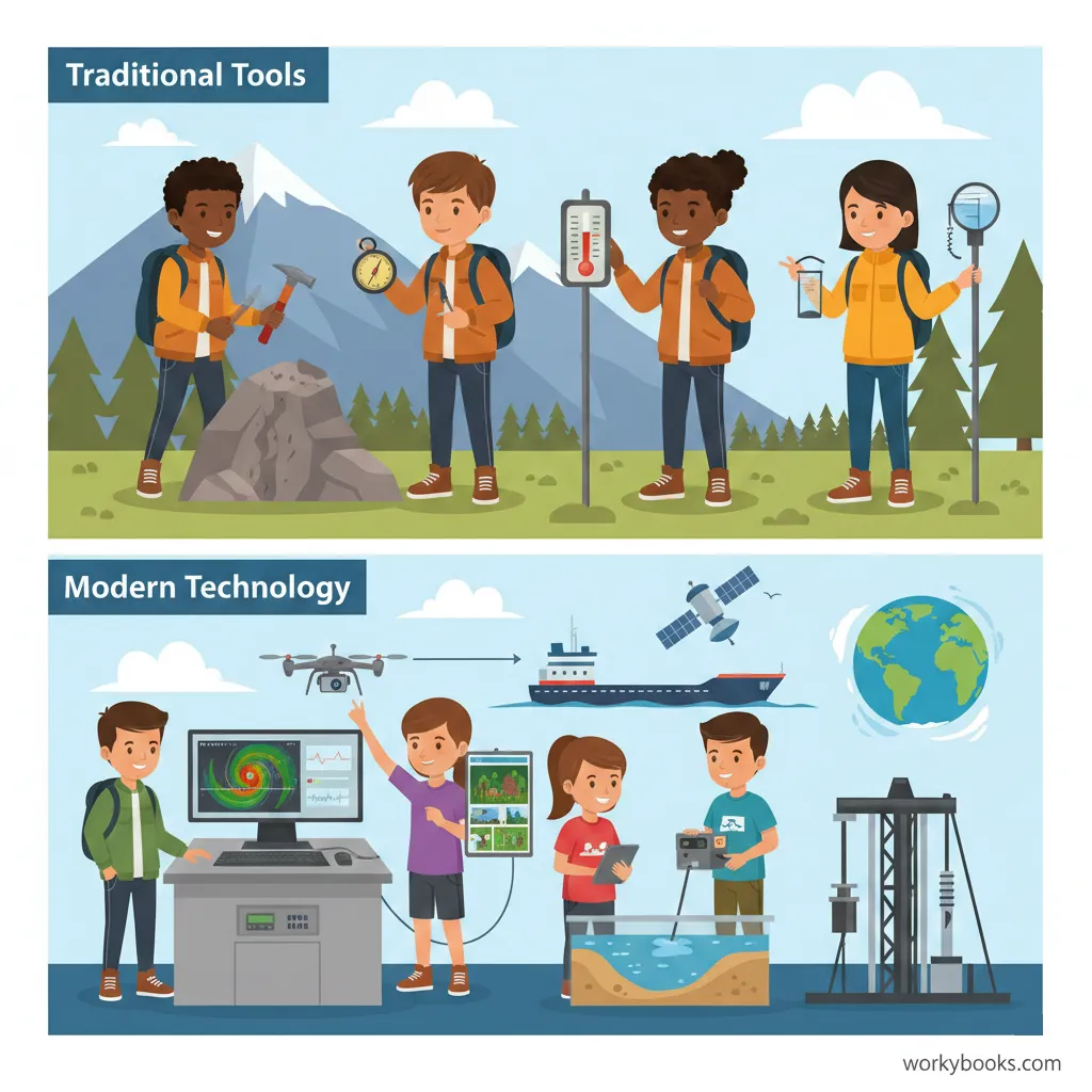
This middle school science reading passage explores the wide range of tools and technologies used in Earth science, from traditional instruments like rock hammers and barometers to advanced modern devices such as satellites, seismographs, and computer models. Students will learn how these tools allow scientists to observe and measure Earth's systems, predict natural hazards, and contribute to global research. The passage supports grades 6-8 science standards (NGSS), and includes glossary terms, differentiated reading levels, comprehension questions, writing prompts, and graphic organizers—making it suitable for varied learning needs. Audio integration and Spanish translations ensure accessibility for diverse classrooms. Teachers can use this resource to support lessons on the Nature of Science, Science and Engineering Practices, and Earth Systems, while engaging students in analyzing the cause-and-effect relationships between technological advances and our growing understanding of the planet.
CONTENT PREVIEW
Expand content preview
Earth Science uses both classic tools and modern technology.
Earth science relies on a combination of traditional tools and advanced technology to investigate the planet’s systems and changes. These instruments help scientists collect accurate data, solve problems, and make predictions about Earth’s future. Understanding the capabilities and limitations of these tools is essential for interpreting scientific findings and improving our knowledge of natural processes.
Traditional Tools in Earth Science
For centuries, earth scientists have used simple, reliable tools to study rocks, weather, and landscapes. A rock hammer allows geologists to split rocks and collect samples for closer examination. The hand lens magnifies minerals, fossils, and soil particles, revealing details invisible to the naked eye. Measuring direction and position is possible with a compass, while instruments like the barometer and thermometer record air pressure and temperature. A rain gauge measures the amount of precipitation over a certain period. Although these tools may seem basic, they provide crucial data for understanding Earth’s surface and atmosphere.
Modern Technology Revolutionizes Earth Science
In recent decades, technology has transformed the way scientists observe and study Earth. Devices like the seismograph detect vibrations caused by earthquakes, allowing scientists to measure their strength and pinpoint their origins. Doppler radar tracks storms and rainfall, improving weather forecasting accuracy. Satellites in orbit capture high-resolution images, monitor climate patterns, and provide GPS data for mapping. Sonar systems use sound waves to map the ocean floor, while core drilling retrieves samples from deep within rocks and ice. These modern tools produce enormous amounts of data, which scientists analyze using computer modeling to simulate processes such as volcanic eruptions, sea-level rise, and climate change.
Remote Sensing and Citizen Science
Remote sensing refers to gathering information from a distance, often through satellites, drones, or aircraft. This method allows scientists to monitor large, hard-to-reach areas, tracking forest loss, glacier retreat, and changes in land use. Technology has also made it possible for ordinary people to contribute to science. Citizen science projects let people use weather stations, earthquake apps, and online platforms to submit observations. This shared data improves the accuracy of research and helps scientists detect patterns or hazards more quickly.
Advances in Earth science tools and technology have made it possible to see inside the planet, monitor global changes, and predict natural hazards before they happen. These innovations save lives, protect property, and help us make better decisions about managing Earth’s resources. As technology continues to evolve, our understanding of the planet will grow, leading to new discoveries and solutions for future challenges.
Interesting Fact: The first weather satellite, TIROS-1, launched in 1960, sent back images that changed how meteorologists forecast storms and track hurricanes worldwide.
Which tool helps a geologist break open rocks to study them?
Rock hammerBarometerHand lensDoppler radar
What is the main purpose of a rain gauge?
To measure temperatureTo measure precipitationTo detect earthquakesTo find direction
How do satellites help earth scientists?
They split rocks open.They measure air pressure.They take images and monitor Earth's changes.They magnify small objects.
What is remote sensing?
Collecting data from a distance, often using satellitesBreaking rocks to study their layersMeasuring rainfall with simple toolsPredicting animal migrations
Which tool detects and records vibrations from earthquakes?
SonarSeismographThermometerCompass
What does 'core drilling' allow scientists to do?
Take samples from deep inside rock or icePredict the weatherMeasure wind speedSee tiny minerals
What is an example of citizen science mentioned in the passage?
Using a hand lens to study rocksOperating a weather station at homeClimbing a volcanoUsing sonar on a ship
Computer modeling helps scientists by:
Taking pictures from spaceSimulating Earth processes and making predictionsMeasuring air pressureDetecting earthquakes
True or False: Traditional tools like the hand lens have no value in modern Earth science.
TrueFalse
True or False: The first weather satellite was launched in the year 1960.
TrueFalse
Perfect For:
👩🏫 Teachers
• Reading comprehension practice
• Auto-graded assessments
• Literacy skill development
👨👩👧👦 Parents
• Reading practice at home
• Comprehension improvement
• Educational reading time
🏠 Homeschoolers
• Reading curriculum support
• Independent reading practice
• Progress monitoring
Reading Features:
📖
Reading Passage
Engaging fiction or nonfiction text
❓
Comprehension Quiz
Auto-graded questions
📊
Instant Feedback
Immediate results and scoring
📄
Printable Version
Download for offline reading
🔊
Read Aloud
Voice-over with word highlighting
Reviews & Ratings
No reviews yet. Be the first to share your experience!
Related Content
Talus Slopes: Formation and Features
This earth science passage explains talus slope formation through mechanical weathering processes, aligning with NGSS MS...