Geography of Ancient Egypt
Interactive passage with audio narration, comprehension questions, and printable PDF.
What's included
Geography of Ancient Egypt preview and details
About this printable Geography of Ancient Egypt reading passage (Grades 5-8)
Sample passage and quiz from Geography of Ancient Egypt
Reading passage and comprehension quiz preview
Geography of Ancient Egypt
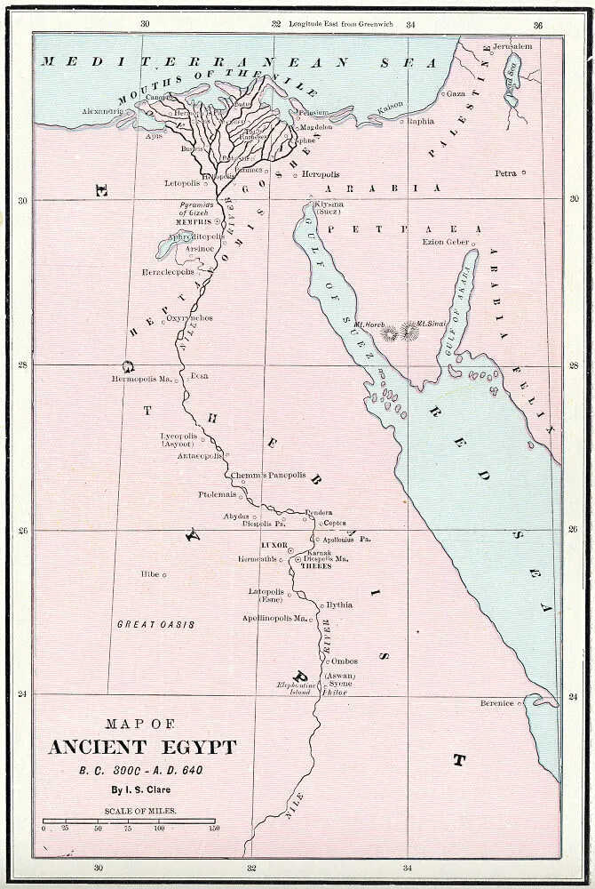
"Map of Ancient Egypt BC 3000-AD 640 - DPLA - c94f2b26e52171ea27e71fc9d37436e9" by Cram, George Franklin, 1841-1928 /
Source: Wikimedia Commons (Public domain).
Ancient Egypt developed along the banks of the Nile River in northeastern Africa. The region’s unique geography, including deserts and the annual flooding of the Nile, shaped its civilization. From about 3100 BCE, the Nile’s predictable waters allowed Egypt to thrive, supporting millions of people over thousands of years.
The Nile River was the lifeblood of Egypt. Each year, the river flooded its banks, leaving behind rich, dark soil known as the "black land." This natural event, described in ancient writings like the Pyramid Texts, enabled Egyptians to practice irrigation, bringing water to crops even during dry periods. Farmers grew wheat, barley, and flax, making Egypt one of the ancient world’s most productive agricultural regions. Archaeological evidence, including ancient canals and tools, shows how Egyptians managed water carefully to prevent both droughts and floods.
Beyond the river, Egypt was surrounded by vast deserts—the Sahara to the west and the Eastern Desert to the east. These deserts acted as natural barriers, protecting Egypt from frequent invasion. This allowed Egyptian society to develop a strong, centralized government led by pharaohs. The deserts also limited contact with other regions, though trade routes did exist, connecting Egypt to Nubia to the south and the Mediterranean world to the north.
Egypt’s geography influenced not only its economy and security, but also daily life and culture. Most people lived close to the Nile, in villages and cities like Memphis and Thebes. The fertile land gave rise to a social hierarchy, with farmers at the base and the pharaoh and priests at the top. Religious beliefs were tied to the river’s cycles; gods such as Hapi were worshipped for ensuring the floods. Over time, technological advances like the shaduf (a manual irrigation tool) and the construction of canals allowed Egypt to support large populations and build monumental architecture such as the pyramids at Giza.
In summary, Ancient Egypt’s geography—especially the Nile River—was critical to its success. The river’s water, the protection of deserts, and the rich soil enabled Egyptians to build a lasting civilization. These features made Egypt both unique and influential, connecting geographic context to the broader story of ancient societies.
As students study world history, examining how geography shaped Ancient Egypt helps explain the rise and fall of other civilizations.
Interesting Fact: The ancient Greek historian Herodotus called Egypt the "gift of the Nile," recognizing how essential the river was to Egyptian life.
Comprehension quiz (8 questions)
1. What river was essential to Egypt?
2. What type of soil did floods leave?
3. Who led the Egyptian government?
4. Why were deserts important to Egypt?
5. How did irrigation help Egyptian farmers?
6. What was the effect of Nile floods?
7. Egyptians grew crops like wheat and barley. True or false?
8. What does 'hierarchy' mean?
Perfect for the way you teach
- Build comprehension skills
- Auto-graded quiz
- Differentiated reading
- Read together at home
- Improve fluency
- Quiet reading time
- Reading curriculum support
- Independent practice
- Track Lexile growth