Inca Roads System Connect the Mountains
Interactive passage with audio narration, comprehension questions, and printable PDF.
By completing this purchase you agree to our Terms of Use and Privacy Policy. Your subscription renews automatically until you cancel. You can cancel anytime from your account settings. All sales are final and non-refundable. Digital content is available for download in your account immediately upon purchase.
What's included
Inca Roads System Connect the Mountains preview and details
About this printable Inca Roads System Connect the Mountains reading passage (Grades 5-8)
Sample passage and quiz from Inca Roads System Connect the Mountains
Reading passage and comprehension quiz preview
Inca Roads System Connect the Mountains
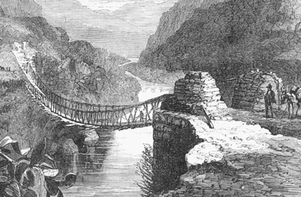
"Inca bridge" by Squier / Wikimedia Commons
The Inca Empire built one of the most advanced infrastructure systems in the ancient world. Their network of roads, called the Qhapaq Ñan, stretched more than 24,000 miles (about 40,000 kilometers) across the Andes Mountains in South America. These roads linked cities, villages, and sacred sites from present-day Colombia to Chile, allowing the Incas to govern a diverse and vast territory.
The Inca road system was a marvel of engineering, especially given the challenging geography of the Andes. The roads ran through deserts, rainforests, and high mountain passes. In some places, the Incas carved stone paths into cliffs or built suspension bridges from woven grass over deep gorges. For example, the Apurímac Bridge, documented in Spanish colonial records, was made entirely from braided grass ropes and could be replaced every year by local communities. Archaeologists have studied surviving Inca roads near Machu Picchu, noting their precise stonework and drainage systems, which helped prevent erosion during heavy rains.
The roads were used by messengers called chasquis, who ran between way stations called tambos. These tambos provided food, shelter, and fresh runners for the relay system. This allowed the Inca ruler, or Sapa Inca, to receive news from distant parts of the empire in just a few days—a remarkable feat for a civilization without horses or wheels. The road system also helped the Incas move their armies quickly in times of danger and supported the movement of goods, such as crops, textiles, and pottery.
Building and maintaining the roads was a collective effort, organized through the Inca labor tax system called mit'a. Commoners contributed work as a form of tribute. Social hierarchy influenced who could use certain parts of the roads; for example, only officials and messengers could travel on the main royal highways, while ordinary people used secondary routes. Despite these rules, the road system helped unify the empire and supported daily life across regions with different languages and customs.
The Inca road system was essential to the empire’s strength and stability. It enabled communication, trade, and control over a huge and difficult landscape. Today, parts of the Qhapaq Ñan are recognized as a UNESCO World Heritage Site, showing how ancient infrastructure can connect people and shape societies over centuries.
This topic connects to broader themes of geography, innovation, and how societies organize themselves to overcome environmental challenges.
Interesting Fact: The only Inca rope bridge still rebuilt every year is the Q’eswachaka Bridge in Peru, maintained using traditional techniques for over 500 years.
Comprehension quiz (8 questions)
1. How long was the Inca road system?
2. What is the Qhapaq Ñan?
3. Who were the chasquis?
4. Why did the Incas build rope bridges?
5. What is a tambo?
6. How did the Inca roads help the empire?
7. Inca roads are still used today. True or false?
8. What does 'infrastructure' mean?
Perfect for the way you teach
- Build comprehension skills
- Auto-graded quiz
- Differentiated reading
- Read together at home
- Improve fluency
- Quiet reading time
- Reading curriculum support
- Independent practice
- Track Lexile growth