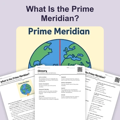
What Is the Longitude of the Prime Meridian? — Reading Comprehension
Rate this
Present
Present in classroom. No work saved
Assign
Classroom with student accounts, Track progress
Quick Play
No student accounts, assign with a link
Grades
3
4
5
6
7
Standards
FL.SS.2.G.1.1
SS.2.G.1.3
PRINT+DIGITAL RESOURCE
This learning resource is available in interactive and printable formats. The interactive worksheet can be played online and assigned to students. The Printable PDF version can be downloaded and printed for completion by hand.
This passage explains that the *Prime Meridian* is the line of *0 degrees longitude* that divides the Earth into the *Eastern* and *Western Hemispheres*. It goes through *Greenwich, England*, and is the starting point for measuring all other lines of *longitude*. Students learn how this line helps us read maps, set time zones, and use GPS. The passage is aligned with Florida standard FL.SS.2.G.1.1 and helps children understand how Earth's geography is measured from east to west.
CONTENT PREVIEW
Expand content preview
What Is the Prime Meridian?
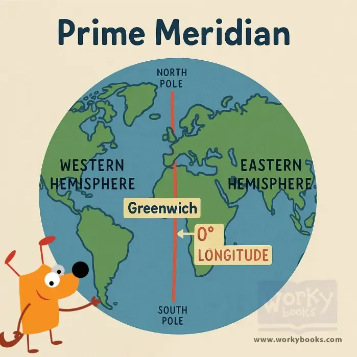
The prime meridian is the starting line for measuring how far east or west a place is on Earth. By definition, the prime meridian has a longitude of 0° (zero degrees). Longitude tells us how far a location is from this line, measured in degrees.
What Does Longitude Mean?
Longitude lines are imaginary lines running from the North Pole to the South Pole. They do not cross each other and help us mark places on the Earth. The prime meridian splits the world into an eastern half and a western half. Places to the east of the prime meridian have positive longitude numbers, up to 180°E. Places to the west have negative numbers, up to 180°W. On the opposite side of the Earth from the prime meridian is the International Date Line at 180°.
How Does the Grid System Work?
The Earth is covered with a grid system made of longitude (east-west) and latitude (north-south) lines. Every location on Earth has a unique coordinate—its own 'address.' For example, New York City is about 74°W longitude and 41°N latitude.
What Are Degrees, Minutes, and Seconds?
Longitude is measured in degrees, but it can also be broken down into smaller parts called minutes and seconds. This helps people find locations very exactly, just like measuring feet and inches instead of just feet.
Why Does 0° Matter?
The prime meridian at 0° longitude is important because it gives everyone the same starting point for measuring. This system helps GPS devices, maps, pilots, and sailors find places anywhere in the world. Before 1884, different countries used different starting lines, which caused confusion. Now, everyone agrees on 0° as the starting line.
Making Connections
Try looking up your town’s longitude! Cities like Greenwich, England, and some places in Africa are right on 0° longitude. Zero degrees longitude is like the start of a measuring tape—the place where everyone begins counting east and west!
Interesting Fact: The prime meridian was chosen at a meeting in 1884 in Washington, D.C. Before that, maps and clocks could be very confusing!
What is the longitude of the prime meridian?
0°180°90°41°N
What do longitude lines measure?
North and southEast and westUp and downDay and night
What is the line at 180° called?
International Date LineEquatorTropic of CancerPrime meridian
Why is 0° longitude important?
It is a universal starting pointIt is the hottest placeIt is where the sun risesIt marks the equator
What is an example of a coordinate?
74°W, 41°N180°S, 0°E0°, 0°41°E, 74°N
What happens if you use different starting lines?
Maps get confusingEarth gets smallerSun rises earlierWater freezes
The prime meridian was chosen in 1884. True or false?
TrueFalse
What does 'coordinate' mean?
Location address on EarthA type of mapA kind of planetA weather tool
Perfect For:
👩🏫 Teachers
• Reading comprehension practice
• Auto-graded assessments
• Literacy skill development
👨👩👧👦 Parents
• Reading practice at home
• Comprehension improvement
• Educational reading time
🏠 Homeschoolers
• Reading curriculum support
• Independent reading practice
• Progress monitoring
Reading Features:
📖
Reading Passage
Engaging fiction or nonfiction text
❓
Comprehension Quiz
Auto-graded questions
📊
Instant Feedback
Immediate results and scoring
📄
Printable Version
Download for offline reading
🔊
Read Aloud
Voice-over with word highlighting
Reviews & Ratings
No reviews yet. Be the first to share your experience!
Related Content
What Is a Hemisphere?
This passage introduces elementary students to the concept of a *hemisphere*, explaining how Earth can be divided into h...
FL.SS.2.G.1.1SS.2.G.1.1
What Is a Topographic Map?
This passage introduces elementary students to the *topographic map*, a special kind of map that shows *elevation* and *...
FL.SS.2.G.1.1SS.2.G.1.2
Finding Our Way with Cardinal Directions
This engaging passage introduces elementary students to the concept of cardinal directions—north, south, east, and west....
FL.SS.2.G.1.1SS.2.G.1.3
In Between the Main Directions
This short passage teaches students about intermediate directions—northeast, southeast, southwest, and northwest—which f...
FL.SS.2.G.1.1SS.2.G.1.3
What Is a Population Map?
This passage teaches students about population maps, a kind of thematic map that shows how many people live in different...
FL.SS.2.G.1.1SS.2.G.1.3
What Is a Political Map?
This passage introduces elementary students to political maps, which show how land is divided into countries, states, an...
FL.SS.2.G.1.1SS.2.G.1.3
The Western Hemisphere
This reading passage introduces students to the *Western Hemisphere*, the half of the Earth located west of the *Prime M...
FL.SS.2.G.1.1SS.2.G.1.2
Which Continents Are in the Western Hemisphere?
This passage teaches elementary students which continents are found in the *Western Hemisphere*, including North America...
FL.SS.2.G.1.1SS.2.G.1.3
The Northern Hemisphere
This passage introduces elementary students to the *Northern Hemisphere*, the half of Earth that lies above the *Equator...
FL.SS.2.G.1.1SS.2.G.1.2
Northern and Southern Hemispheres
This passage explains the difference between the *Northern Hemisphere* and the *Southern Hemisphere*, the two halves of ...
FL.SS.2.G.1.1SS.2.G.1.3
Where Is the Equator?
This passage teaches students about the *Equator*, the imaginary line that divides Earth into the *Northern* and *Southe...
FL.SS.2.G.1.1SS.2.G.1.2
Countries on the Equator
This passage introduces students to countries located on the *Equator*, including Ecuador, Brazil, Kenya, and Indonesia....
FL.SS.2.G.1.1SS.2.G.1.3
Understanding Cardinal Directions
This engaging passage explains the concept of cardinal directions—north, south, east, and west—and their importance in n...
FL.SS.2.G.1.1SS.2.G.1.1
What Is the Prime Meridian?
This passage explains the *Prime Meridian*, the imaginary line that runs from the *North Pole* to the *South Pole* and d...
FL.SS.2.G.1.1SS.2.G.1.3
Are Directions Capitalized?
This passage teaches students about capitalization rules for direction words such as north, south, east, and west. It ex...
FL.SS.2.G.1.1SS.2.G.1.1
My Room and My House
This passage introduces young learners to the idea of personal space by starting with the room and expanding to the hous...
FL.SS.2.G.1.1SS.2.G.1.3
My Street and My Neighborhood
This reading passage helps students understand the concepts of a street and a neighborhood. It highlights how neighborho...
FL.SS.2.G.1.1SS.2.G.1.3
My Town or City
In this passage, students learn how their towns and cities are structured. It explains the role of neighborhoods, commun...
FL.SS.2.G.1.1SS.2.G.1.2
My State or Province
This geography passage teaches students about states or provinces as larger political areas made up of many towns and ci...