This learning resource is available in interactive and printable formats. The interactive worksheet can be played online and assigned to students. The Printable PDF version can be downloaded and printed for completion by hand.
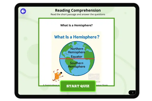
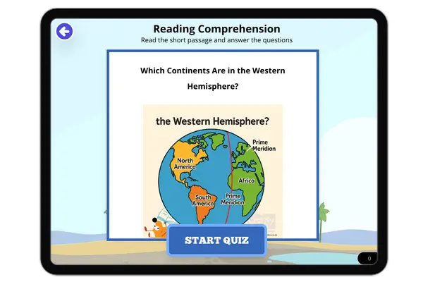
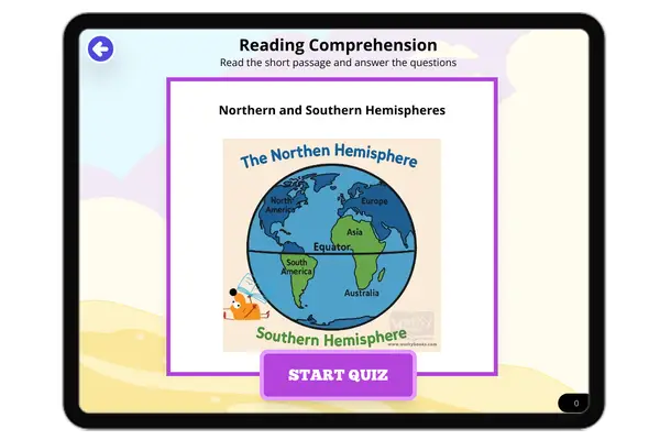
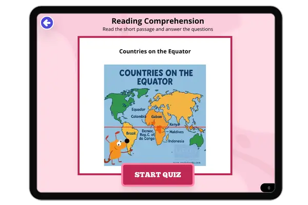
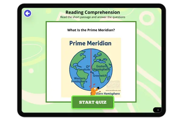
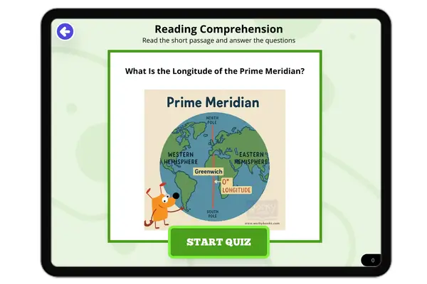
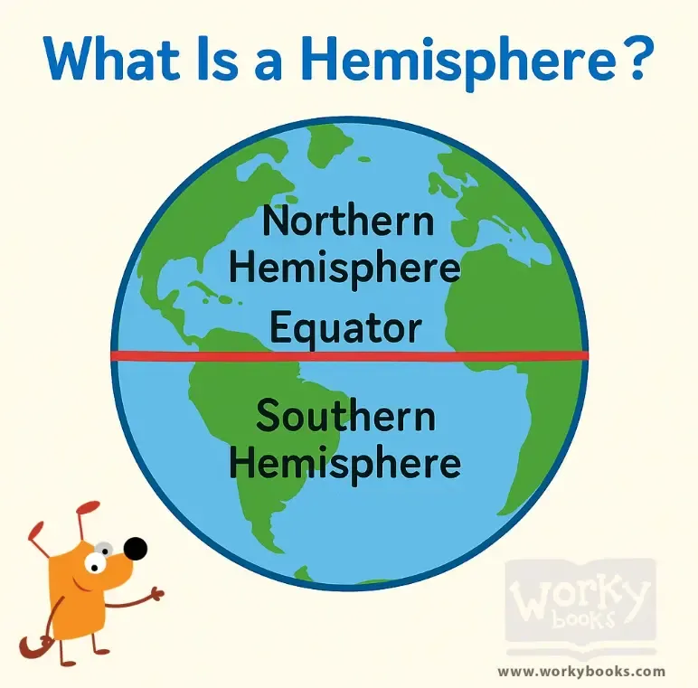
This reading passage introduces students to the *Western Hemisphere*, the half of the Earth located west of the *Prime Meridian*. Aligned with Florida standard FL.SS.2.G.1.1, the passage explores which continents and countries are in the Western Hemisphere, including North and South America. It explains the roles of imaginary lines like the Prime Meridian and the Equator in geography. Young readers will learn about the Amazon Rainforest, landforms, and different cultures found in this hemisphere. With simple explanations and key vocabulary, this passage helps kids build strong geography skills.
CONTENT PREVIEW
Expand content preview
Western Hemisphere
The Western Hemisphere is half of the planet Earth. It covers everything west of the prime meridian, which is the line at 0° longitude running through Greenwich, England. The opposite line on the globe is 180° longitude. From the prime meridian to 180°, you find the Western Hemisphere. The Eastern Hemisphere is the other half.
The Western Hemisphere is home to all of North America, including the United States, Canada, and Mexico. It also contains Central America, South America, the Caribbean islands, Greenland, and even part of western Africa and Europe. Half of Antarctica is also in the Western Hemisphere. On a globe, this area looks like the left half if you split the world down the middle.
This hemisphere has many famous landforms. The Rocky Mountains run through North America, and the Andes Mountains stretch down South America. The Amazon Rainforest is the largest rainforest in the world, and the Amazon River is the biggest river by how much water it carries. The Great Lakes are a group of huge lakes, and the Mississippi River is one of the longest rivers in North America. The Grand Canyon is a giant, colorful canyon in the United States.
About one-third of all the land on Earth is in the Western Hemisphere. It is home to around 1 billion people. When it is daytime in the Western Hemisphere, it is nighttime in the Eastern Hemisphere because of how the Earth spins. This area is called 'Western' because, from Europe, explorers like Christopher Columbus sailed west to reach the Americas in 1492. The word 'western' depends on where the prime meridian was placed, which was in England.
Interesting Fact: The Andes Mountains in South America are the longest mountain range in the world!
What divides Earth into hemispheres?
Prime meridian and 180° longitudeEquator and North PoleAmazon RiverRocky Mountains
Which mountains are in South America?
Andes MountainsRocky MountainsAlpsHimalayas
Which river has the most water?
Amazon RiverMississippi RiverNile RiverYangtze River
Why is it called the 'Western' Hemisphere?
Europeans sailed west to the AmericasIt is warmer than the eastIt has more countriesIt is smaller
What happens when it's day in the Western Hemisphere?
It's night in the Eastern HemisphereIt's also day everywhereIt's winterIt rains everywhere
What is the Grand Canyon?
A large colorful canyonA rainforestA mountain rangeA river
The Andes are the longest mountain range. True or false?
TrueFalse
What does 'longitude' mean?
Lines measuring east and westBig mountainsA type of riverAn explorer
Perfect For:
👩🏫 Teachers
• Reading comprehension practice
• Auto-graded assessments
• Literacy skill development
👨👩👧👦 Parents
• Reading practice at home
• Comprehension improvement
• Educational reading time
🏠 Homeschoolers
• Reading curriculum support
• Independent reading practice
• Progress monitoring
Reading Features:
📖
Reading Passage
Engaging fiction or nonfiction text
❓
Comprehension Quiz
Auto-graded questions
📊
Instant Feedback
Immediate results and scoring
📄
Printable Version
Download for offline reading
🔊
Read Aloud
Voice-over with word highlighting
Reviews & Ratings
No reviews yet. Be the first to share your experience!
Related Content
What Is a Hemisphere?
This passage introduces elementary students to the concept of a *hemisphere*, explaining how Earth can be divided into h...
FL.SS.2.G.1.1SS.2.G.1.1
What Is a Topographic Map?
This passage introduces elementary students to the *topographic map*, a special kind of map that shows *elevation* and *...
FL.SS.2.G.1.1SS.2.G.1.2
Finding Our Way with Cardinal Directions
This engaging passage introduces elementary students to the concept of cardinal directions—north, south, east, and west....
FL.SS.2.G.1.1SS.2.G.1.3
In Between the Main Directions
This short passage teaches students about intermediate directions—northeast, southeast, southwest, and northwest—which f...
FL.SS.2.G.1.1SS.2.G.1.3
What Is a Physical Map?
This passage introduces young students to physical maps and explains how they show Earth's natural features such as moun...
FL.SS.2.G.1.1SS.2.G.1.2
What Is a Population Map?
This passage teaches students about population maps, a kind of thematic map that shows how many people live in different...
FL.SS.2.G.1.1SS.2.G.1.3
What Is a Political Map?
This passage introduces elementary students to political maps, which show how land is divided into countries, states, an...
FL.SS.2.G.1.1SS.2.G.1.3
Which Continents Are in the Western Hemisphere?
This passage teaches elementary students which continents are found in the *Western Hemisphere*, including North America...
FL.SS.2.G.1.1SS.2.G.1.3
The Northern Hemisphere
This passage introduces elementary students to the *Northern Hemisphere*, the half of Earth that lies above the *Equator...
FL.SS.2.G.1.1SS.2.G.1.2
Northern and Southern Hemispheres
This passage explains the difference between the *Northern Hemisphere* and the *Southern Hemisphere*, the two halves of ...
FL.SS.2.G.1.1SS.2.G.1.3
Where Is the Equator?
This passage teaches students about the *Equator*, the imaginary line that divides Earth into the *Northern* and *Southe...
FL.SS.2.G.1.1SS.2.G.1.2
Countries on the Equator
This passage introduces students to countries located on the *Equator*, including Ecuador, Brazil, Kenya, and Indonesia....
FL.SS.2.G.1.1SS.2.G.1.3
Understanding Cardinal Directions
This engaging passage explains the concept of cardinal directions—north, south, east, and west—and their importance in n...
FL.SS.2.G.1.1SS.2.G.1.1
What Is the Prime Meridian?
This passage explains the *Prime Meridian*, the imaginary line that runs from the *North Pole* to the *South Pole* and d...
FL.SS.2.G.1.1SS.2.G.1.3
What Is the Longitude of the Prime Meridian?
This passage explains that the *Prime Meridian* is the line of *0 degrees longitude* that divides the Earth into the *Ea...
FL.SS.2.G.1.1SS.2.G.1.3
Are Directions Capitalized?
This passage teaches students about capitalization rules for direction words such as north, south, east, and west. It ex...
FL.SS.2.G.1.1SS.2.G.1.1
My Room and My House
This passage introduces young learners to the idea of personal space by starting with the room and expanding to the hous...
FL.SS.2.G.1.1SS.2.G.1.3
My Street and My Neighborhood
This reading passage helps students understand the concepts of a street and a neighborhood. It highlights how neighborho...
FL.SS.2.G.1.1SS.2.G.1.3
My Town or City
In this passage, students learn how their towns and cities are structured. It explains the role of neighborhoods, commun...