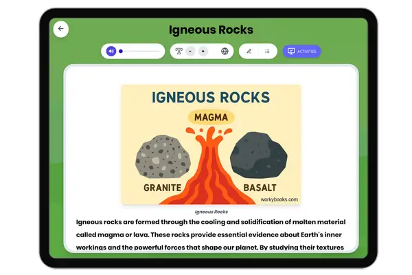
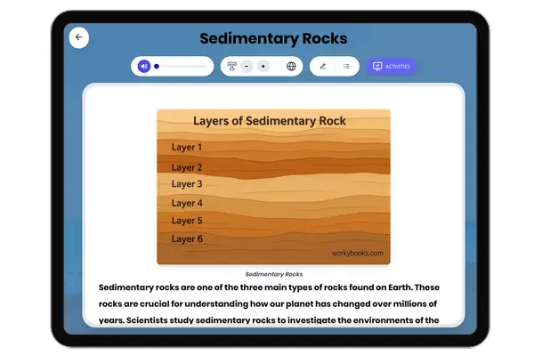
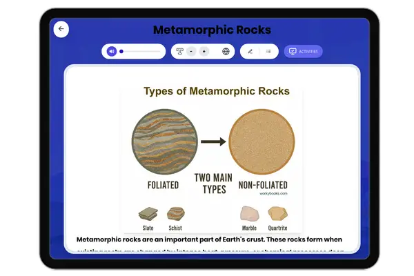
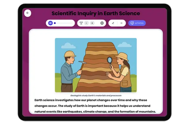
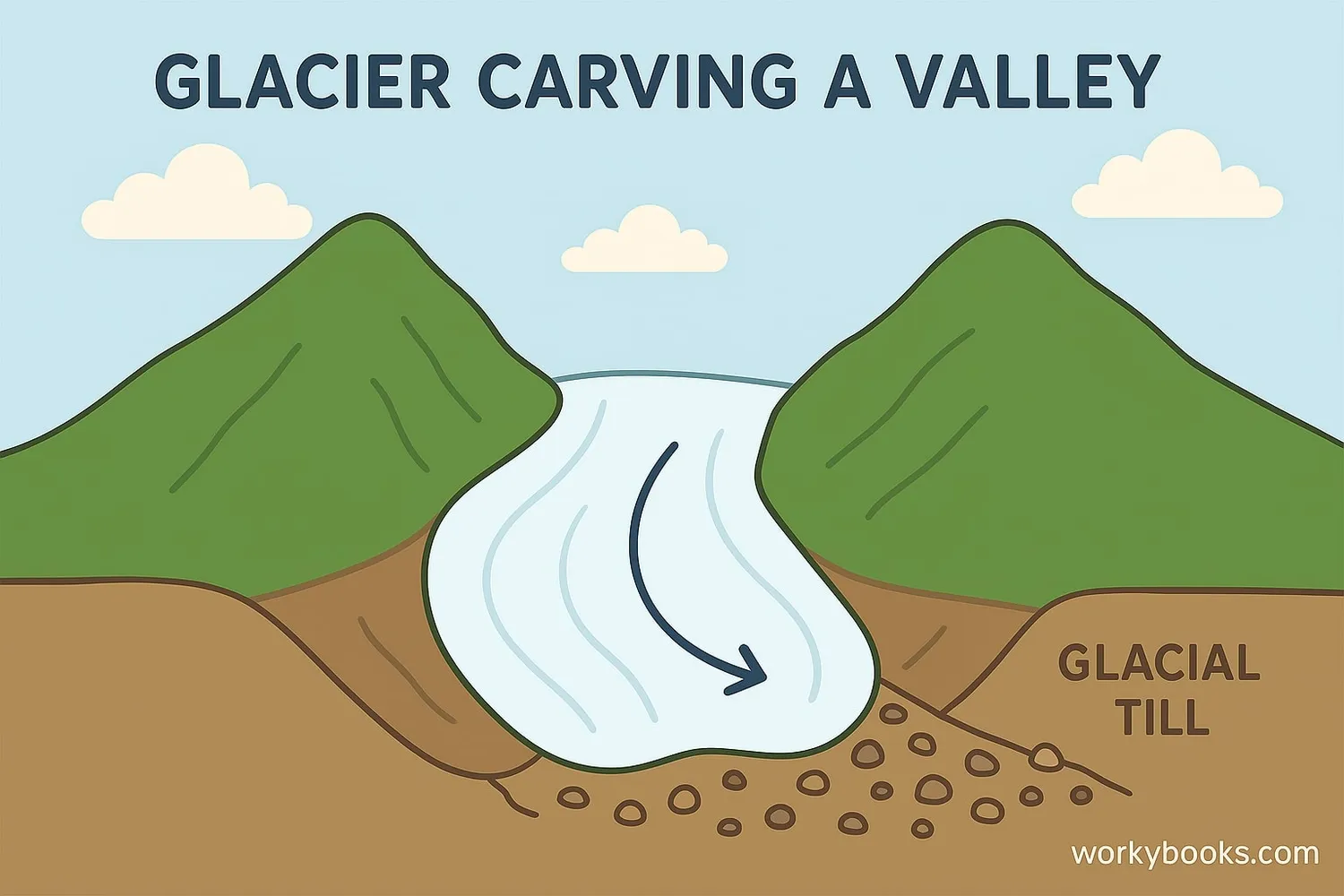
This middle school science passage explores glacial erosion and deposition, focusing on the mechanisms by which glaciers shape Earth's surface. Students will learn how alpine and continental glaciers move, erode rock through processes like plucking and abrasion, and form distinctive landforms such as U-shaped valleys, cirques, arêtes, horns, moraines, drumlins, eskers, and kettle lakes. The passage integrates scientific thinking by explaining the evidence geologists use to reconstruct past glacial activity and discusses the effects of ice ages on landscapes. Aligned to NGSS standard MS-ESS2-1, this resource includes a differentiated version for accessibility, Spanish translations, a glossary, comprehension quiz, writing prompts, and graphic organizers. All content is suitable for grades 6-8 and audio-integrated for diverse learners.
Written by Workybooks TeamPublished by Workybooks
Preview
Sample passage and quiz content
CONTENT PREVIEW
Expand content preview
Glacier shaping the landscape through erosion and deposition
Glaciers are massive, moving bodies of ice that are among the most powerful agents of erosion on Earth. In regions from high mountain valleys to entire continents, glaciers have dramatically shaped the landscape. Scientists study glacial landforms to understand both past and present processes that shape Earth’s surface. Glaciers not only carve valleys and move rocks, but they also deposit sediments, leaving behind features that reveal the incredible force of ice.
How Glaciers Erode the Land
There are two main types of glaciers: alpine glaciers (also called valley glaciers) and continental glaciers (or ice sheets). Alpine glaciers flow down mountain valleys, while continental glaciers cover vast land areas. Glaciers move slowly under their own weight—sometimes only a few centimeters to several meters per day. As a glacier advances, it picks up rocks by plucking, a process where ice freezes to bedrock and pulls pieces away. Another process, abrasion, occurs when rocks frozen in the glacier grind against the ground, scraping and polishing the surface. Over time, these actions create distinctive landforms such as U-shaped valleys, cirques (bowl-shaped depressions), arêtes (sharp ridges), and horns (pointed peaks).
Deposition by Glaciers
Glaciers are not only destructive—they also build up new landscapes through deposition. As glaciers melt, they drop the material they carried, called till. Till is unsorted sediment, made up of everything from fine silt to large boulders. Sometimes, meltwater streams sort and carry away smaller particles, creating outwash plains. Glacial deposition forms unique features including moraines (piles or ridges of till), drumlins (elongated hills), eskers (long winding ridges of sand and gravel), and kettle lakes (small lakes formed by melting ice blocks).
Glaciers and the Ice Ages
Throughout Earth’s history, periods known as ice ages have occurred, when global temperatures dropped and glaciers expanded over continents. During the last ice age, which ended about 12,000 years ago, nearly 30 percent of Earth’s surface was covered by ice. The evidence of these ancient glaciers is seen today in the landforms they left behind. For example, the Great Lakes in North America were formed by glacial erosion and deposition. By studying these features, scientists can reconstruct past climates and better predict how today’s changing climate could affect glacial regions.
Glaciers are powerful, dynamic systems that shape our planet in lasting ways. Their ability to erode, transport, and deposit material illustrates the interconnectedness of Earth’s surface processes. Understanding glacial action helps scientists explain present-day landscapes and anticipate future changes in a warming world.
Interesting Fact: Some glaciers can flow at speeds up to 30 meters per day during surges, but most move much more slowly—only a few centimeters to a few meters each day.
What is the main role of glaciers in shaping Earth's surface?
They erode and deposit materials, creating new landforms.They increase Earth's temperature.They cause earthquakes.They only melt and disappear.
Which type of glacier flows down a mountain valley?
Alpine glacierContinental glacierIce shelfArête
What is plucking?
The process where ice freezes to rock and pulls pieces away.The grinding of rocks in ice.Melting of glaciers.Formation of lakes.
What is till?
Unsorted sediment left by a glacier.A type of mountain.Sorted sand and gravel from rivers.A large ice block.
In the passage, what does 'abrasion' mean?
Grinding and scraping of rock surfaces by rocks in the glacier.Freezing of ice to the ground.Melting of glacier ice.Forming of valleys.
What landform is created by glacial erosion that has a flat bottom and steep sides?
U-shaped valleyMoraineEskerDrumlin
If scientists find a kettle lake, what can they infer?
A glacier once melted there, leaving ice blocks behind.A volcano erupted nearby.The area was always warm.It was formed by river erosion.
How can studying glacial landforms help scientists predict future changes?
By understanding past climates and glacial movement, scientists can predict how glaciers might change with climate.By showing how earthquakes occur.By helping animals adapt to cold.By causing more ice ages.
True or False: All glaciers move at the same speed every day.
TrueFalse
True or False: Moraines are formed by the erosion of rivers.