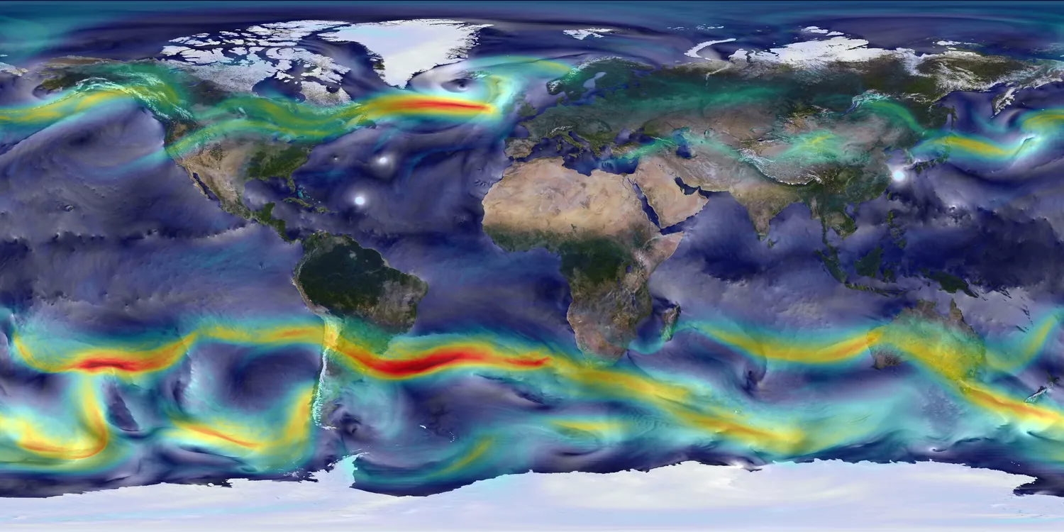
This comprehensive passage introduces middle school students to global wind patterns and atmospheric circulation, aligning with NGSS MS-ESS2-6. Students will explore how uneven heating of Earth’s surface creates convection cells, resulting in major wind belts and influencing weather around the globe. The passage covers the mechanisms of Hadley, Ferrel, and Polar cells, discusses surface winds like the trade winds and westerlies, and introduces jet streams. It promotes scientific thinking by explaining how observations and data have shaped our understanding of global wind systems. The resource includes a glossary, differentiated versions for struggling readers, multiple-choice and writing activities, and graphic organizers to support comprehension. Audio integration enhances accessibility for diverse learners. This passage is ideal for building foundational knowledge of Earth’s atmospheric processes and their impact on climate, ecosystems, and human society.
Written by Workybooks TeamPublished by Workybooks
Preview
Sample passage and quiz content
CONTENT PREVIEW
Expand content preview
High-resolution global atmospheric modeling provides a unique tool to study the role of weather within Earth’s climate system. NASA’s Goddard Earth Observing System Model (GEOS-5) is capable of simulating worldwide weather at resolutions as fine as 3.5 kilometers.This visualization shows global winds from a GEOS-5 simulation using 10-kilometer resolution. Surface winds (0 to 40 meters/second) are shown in white and trace features including Atlantic and Pacific cyclones. Upper-level winds (250 hectopascals) are colored by speed (0 to 175 meters/second), with red indicating faster. NASA Goddard Space Flight Center / Wikimedia Commons (Public domain).
Global wind patterns are a fundamental part of Earth’s climate system, influencing weather, ocean currents, and the distribution of heat and moisture across the planet. Scientists have observed that winds do not move in straight lines from the equator to the poles. Instead, they follow complex paths shaped by several interacting forces. Understanding these patterns helps explain why certain regions are wet, dry, warm, or cold, and why weather can change rapidly.
Uneven Heating and Convection Cells
The driving force behind global wind patterns is the uneven heating of Earth’s surface. The equator receives more direct solar energy than the poles, causing air at the equator to warm, expand, and rise. This rising air creates a low-pressure zone. As the air ascends, it cools and moves toward higher latitudes. Around 30° north and south, the cooled air sinks, forming high-pressure zones. This cycle establishes a convection cell called the Hadley cell, which operates from the equator to about 30° latitude. Between 30° and 60° latitude lies the Ferrel cell, which is driven by the movement of neighboring cells. Near the poles, the Polar cell circulates air from 60° to 90° latitude. Each hemisphere contains these three main convection cells, creating a repeating pattern north and south of the equator.
Surface Wind Belts and the Jet Stream
The movement of air within these cells produces distinct surface wind belts. Near the equator, the doldrums are calm regions with little wind, while between 0° and 30°, steady trade winds blow from east to west. Around 30°, the horse latitudes are again calm. From 30° to 60°, the westerlies blow from west to east, and from 60° to the poles, cold polar easterlies flow from east to west. Above these surface winds, narrow bands of strong wind called jet streams flow in the upper atmosphere. These jet streams, which can reach speeds over 250 kilometers per hour, influence the movement of storms and weather systems.
Interactions and Real-World Impacts
Global wind patterns do more than move air. They transport heat from the equator toward the poles, balancing Earth’s temperature differences. This process affects rainfall, ocean currents, and even the paths of hurricanes. For example, the westerlies are important for carrying weather systems across North America and Europe, while trade winds helped early sailors travel across the Atlantic and Pacific Oceans. Scientists use satellites and weather balloons to study these winds and predict weather changes. Understanding global wind patterns is crucial for forecasting, preparing for extreme weather, and addressing climate change.
In summary, global wind patterns result from the interplay of solar energy, Earth’s rotation, and convection currents. These patterns connect different parts of the atmosphere in a giant system, supporting life by moving air, water, and energy around the globe.
Interesting Fact: The strongest jet streams in Earth’s atmosphere can travel faster than some commercial airplanes, sometimes reaching over 400 kilometers per hour!
What is the main cause of global wind patterns?
Uneven heating of Earth's surface by the sunEarthquake activityThe movement of tectonic platesThe moon's gravity
What is the name of the convection cell that operates from the equator to about 30° latitude?
Hadley cellFerrel cellPolar cellTrade wind cell
Which wind belt is known for being calm and windless near the equator?
DoldrumsWesterliesHorse latitudesPolar easterlies
What is one role of the westerlies mentioned in the passage?
Carrying weather systems across North America and EuropeCreating earthquakesProducing volcanic eruptionsMaking the equator warmer
What does the term 'jet stream' mean as used in the passage?
A narrow band of fast-moving air in the upper atmosphereA river in South AmericaA type of surface wind at the equatorA wind that only happens at the poles
What does 'convection cell' mean in this context?
A circular pattern of air movement caused by warm air rising and cool air sinkingA container used for experimentsA weather balloonA type of cloud
Why do trade winds blow from east to west between the equator and 30° latitude?
Because of the movement of air in the Hadley cell and Earth's rotationDue to the moon's pullBecause of earthquakesBecause of volcanoes
How do global wind patterns help balance Earth's temperature?
By moving heat from the equator toward the polesBy blocking solar energyBy stopping all rainBy creating deserts everywhere
True or False: The Ferrel cell is found between 30° and 60° latitude.
TrueFalse
True or False: Jet streams move slower than all surface winds.
TrueFalse
Who it's for
Perfect for the way you teach
Teachers
Build comprehension skills
Auto-graded quiz
Differentiated reading
Parents
Read together at home
Improve fluency
Quiet reading time
Homeschoolers
Reading curriculum support
Independent practice
Track Lexile growth
Topics
global wind patternsHadley cellFerrel cellPolar cellatmospheric circulationsurface windsjet streammiddle school science
Reviews & Ratings
No reviews yet. Be the first to share your experience!
More reading you might love
19 more
Understanding the Koppen Climate Classification System
MS-ESS2-6MS-LS2-5
$1.50
What Is a Temperate Climate?
MS-ESS2-6
$1.50
What Is the Temperate Zone?
MS-ESS2-6
FREE
Humid Continental Climate Characteristics
MS-ESS2-6
$1.50
Humid Continental Climate Countries
MS-ESS2-6
FREE
How Do Highland Climates Differ from Polar Climates?
MS-ESS2-6
$1.50
Which Factor Controls the Water Cycle?
MS-ESS2-6
$1.50
What Is Condensation in the Water Cycle?
MS-ESS2-6
$1.50
What Are Natural Causes That Lead to Increased CO₂ Levels in the Carbon Cycle?