
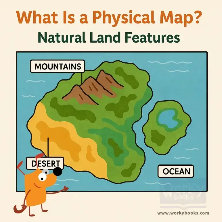
What Is a Physical Map? — Reading Comprehension

Grades
  • 3
  • 4
  • 5
  • 6
  • 7
Standards
  • FL.SS.2.G.1.1
  • SS.2.G.1.2
SHARE

About This Reader

This passage introduces young students to physical maps and explains how they show Earth's natural features such as mountains, rivers, lakes, and deserts. Students learn how different colors on the map represent various land types and elevations. The passage aligns with Florida standard SS.2.G.1.1 by helping students understand how to use maps to locate physical features. With real-life examples, simple vocabulary, and engaging content, this passage builds geography skills, supports map-reading practice, and promotes reading comprehension for grades 2–3.

Perfect For:

👩‍🏫 Teachers
  • • Reading comprehension practice
  • • Auto-graded assessments
  • • Literacy skill development
👨‍👩‍👧‍👦 Parents
  • • Reading practice at home
  • • Comprehension improvement
  • • Educational reading time
🏠 Homeschoolers
  • • Reading curriculum support
  • • Independent reading practice
  • • Progress monitoring

Reading Features:

📖
Reading Passage
Engaging fiction or nonfiction text
Comprehension Quiz
Auto-graded questions
📊
Instant Feedback
Immediate results and scoring
📄
Printable Version
Download for offline reading
🔊
Read Aloud
Voice-over with word highlighting
What Is a Hemisphere? - reading educational content
What Is a Hemisphere?
This passage introduces elementary students to the concept of a *hemisphere*, explaining how Earth can be divided into h...
FL.SS.2.G.1.1SS.2.G.1.1
What Is a Topographic Map? - reading educational content
What Is a Topographic Map?
This passage introduces elementary students to the *topographic map*, a special kind of map that shows *elevation* and *...
FL.SS.2.G.1.1SS.2.G.1.2
Finding Our Way with Cardinal Directions - reading educational content
Finding Our Way with Cardinal Directions
This engaging passage introduces elementary students to the concept of cardinal directions—north, south, east, and west....
FL.SS.2.G.1.1SS.2.G.1.3
In Between the Main Directions - reading educational content
In Between the Main Directions
This short passage teaches students about intermediate directions—northeast, southeast, southwest, and northwest—which f...
FL.SS.2.G.1.1SS.2.G.1.3
What Is a Population Map? - reading educational content
What Is a Population Map?
This passage teaches students about population maps, a kind of thematic map that shows how many people live in different...
FL.SS.2.G.1.1SS.2.G.1.3
What Is a Political Map? - reading educational content
What Is a Political Map?
This passage introduces elementary students to political maps, which show how land is divided into countries, states, an...
FL.SS.2.G.1.1SS.2.G.1.3
The Western Hemisphere - reading educational content
The Western Hemisphere
This reading passage introduces students to the *Western Hemisphere*, the half of the Earth located west of the *Prime M...
FL.SS.2.G.1.1SS.2.G.1.2
Which Continents Are in the Western Hemisphere? - reading educational content
Which Continents Are in the Western Hemisphere?
This passage teaches elementary students which continents are found in the *Western Hemisphere*, including North America...
FL.SS.2.G.1.1SS.2.G.1.3
The Northern Hemisphere - reading educational content
The Northern Hemisphere
This passage introduces elementary students to the *Northern Hemisphere*, the half of Earth that lies above the *Equator...
FL.SS.2.G.1.1SS.2.G.1.2
Northern and Southern Hemispheres - reading educational content
Northern and Southern Hemispheres
This passage explains the difference between the *Northern Hemisphere* and the *Southern Hemisphere*, the two halves of ...
FL.SS.2.G.1.1SS.2.G.1.3
Where Is the Equator? - reading educational content
Where Is the Equator?
This passage teaches students about the *Equator*, the imaginary line that divides Earth into the *Northern* and *Southe...
FL.SS.2.G.1.1SS.2.G.1.2
Countries on the Equator - reading educational content
Countries on the Equator
This passage introduces students to countries located on the *Equator*, including Ecuador, Brazil, Kenya, and Indonesia....
FL.SS.2.G.1.1SS.2.G.1.3
Understanding Cardinal Directions - reading educational content
Understanding Cardinal Directions
This engaging passage explains the concept of cardinal directions—north, south, east, and west—and their importance in n...
FL.SS.2.G.1.1SS.2.G.1.1
What Is the Prime Meridian? - reading educational content
What Is the Prime Meridian?
This passage explains the *Prime Meridian*, the imaginary line that runs from the *North Pole* to the *South Pole* and d...
FL.SS.2.G.1.1SS.2.G.1.3
What Is the Longitude of the Prime Meridian? - reading educational content
What Is the Longitude of the Prime Meridian?
This passage explains that the *Prime Meridian* is the line of *0 degrees longitude* that divides the Earth into the *Ea...
FL.SS.2.G.1.1SS.2.G.1.3
Are Directions Capitalized? - reading educational content
Are Directions Capitalized?
This passage teaches students about capitalization rules for direction words such as north, south, east, and west. It ex...
FL.SS.2.G.1.1SS.2.G.1.1
My Room and My House - reading educational content
My Room and My House
This passage introduces young learners to the idea of personal space by starting with the room and expanding to the hous...
FL.SS.2.G.1.1SS.2.G.1.3
My Street and My Neighborhood - reading educational content
My Street and My Neighborhood
This reading passage helps students understand the concepts of a street and a neighborhood. It highlights how neighborho...
FL.SS.2.G.1.1SS.2.G.1.3
My Town or City - reading educational content
My Town or City
In this passage, students learn how their towns and cities are structured. It explains the role of neighborhoods, commun...
FL.SS.2.G.1.1SS.2.G.1.2
Copyright © 2025 Workybooks. Made with ♥ in California.