Coastal Landforms
Interactive passage with audio narration, comprehension questions, and printable PDF.
What's included
Coastal Landforms preview and details
About this printable Coastal Landforms science reading passage, NGSS-aligned (Grades 5-8)
Sample passage and quiz from Coastal Landforms
Reading passage and comprehension quiz preview
Coastal Landforms
Coastal landforms are the physical features found where land meets the ocean. These environments are always changing because of the powerful forces of waves, currents, and tides. Some coastlines are rugged and rocky, while others are smooth and sandy. Understanding why these differences exist requires examining the processes of erosion and deposition. Scientists observe these changes over years and use data to explain how land and water interact to shape our planet's edge.
Erosional Landforms: The Work of Waves
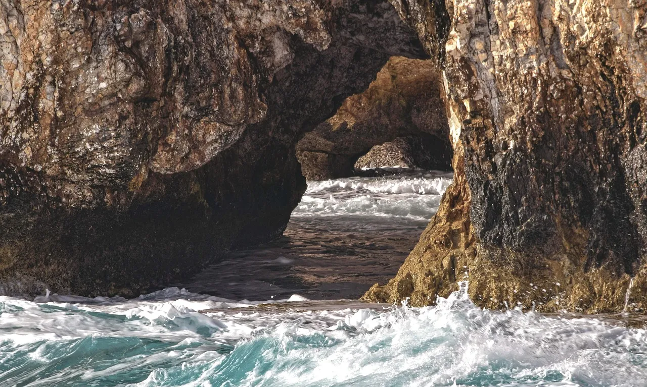
Waves are one of the most important forces that shape coastlines. As waves crash against the shore, they erode, or wear away, the rocks and soil. Over time, this process creates dramatic landforms. For example, sea cliffs form when wave action undercuts the base of a rocky coast, causing the land above to collapse. In places where the rock has weak zones, waves can carve out sea caves. If these caves grow larger and eventually break through a headland, they form sea arches. When a sea arch collapses, it leaves behind an isolated pillar called a sea stack. At the base of retreating cliffs, wave energy flattens the area into a wave-cut platform. These erosional features tell geologists how coastlines have changed over time and provide evidence of the ongoing power of the ocean.
Depositional Landforms: Building Up the Coast
Not all coastal change is destructive. The ocean also builds new land through deposition, which is the process of dropping or adding material to the shore. Beaches are created when waves and currents deposit sand, gravel, or shells along the coast. The size and composition of beach material depend on the energy of the waves and the source of the sediment. Spits are narrow strips of sand or gravel that extend from the coastline into the water, often formed by the longshore current moving material down the shore. Barrier islands are long, narrow islands that run parallel to the mainland, separated by a lagoon or bay. They protect the coast from storms and rising sea levels. Tombolos form when sand or gravel connects an offshore island to the mainland, acting as a natural bridge. These depositional landforms are evidence of how the coast can grow and change shape over time.
Dynamic Systems: Changing Coastlines
Coastlines are dynamic, meaning they are constantly changing. Storms, sea-level rise, and human activities can speed up erosion or deposition. For instance, severe storms may erode a beach overnight, while calm periods allow new sand to accumulate. Scientists measure rates of shoreline change, sometimes seeing cliffs retreat by more than a meter per year or barrier islands shifting position after hurricanes. The type of coast—rocky or sandy—depends on local geology, wave energy, and sediment supply. Understanding these systems helps communities manage risks like flooding and habitat loss. It also connects to larger Earth science principles, such as the cycling of materials and the interaction of Earth's spheres.
Coastal landforms are shaped by a balance between forces that wear away and those that build up the land. By studying these features, scientists gain insight into the dynamic nature of our planet and how human actions can influence Earth's changing edge.
Interesting Fact: Some barrier islands can migrate tens of meters in a single year due to powerful storms and shifting currents!
Comprehension quiz (10 questions)
1. What is the main process that forms sea cliffs?
2. Which landform is created when a sea arch collapses?
3. What is deposition?
4. What does the passage say about barrier islands?
5. What does the word 'dynamic' mean in the passage?
6. In the context of the passage, what is a 'spit'?
7. Why do scientists study coastal landforms?
8. How can human activities affect coastlines?
9. Barrier islands never move. (True/False)
10. Erosion and deposition are both important in shaping coastal landforms. (True/False)
Perfect for the way you teach
- Build comprehension skills
- Auto-graded quiz
- Differentiated reading
- Read together at home
- Improve fluency
- Quiet reading time
- Reading curriculum support
- Independent practice
- Track Lexile growth