Desert and Arid Landforms
Interactive passage with audio narration, comprehension questions, and printable PDF.
What's included
Desert and Arid Landforms preview and details
About this printable Desert and Arid Landforms science reading passage, NGSS-aligned (Grades 5-8)
Sample passage and quiz from Desert and Arid Landforms
Reading passage and comprehension quiz preview
Desert and Arid Landforms
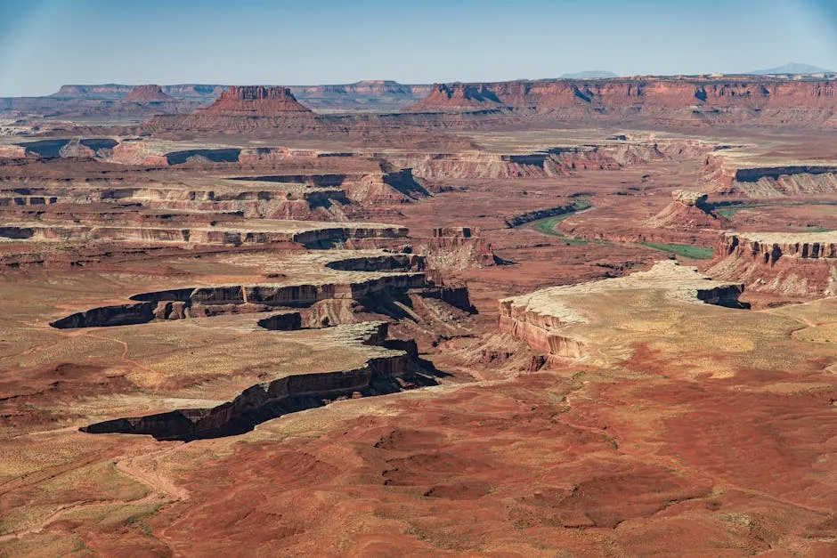
"An aerial view of the rugged canyons in Canyonlands National Park, Utah." by Lacza / Pexels.
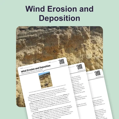
Deserts and arid regions cover about one-third of Earth’s land surface. These dry environments are defined by receiving less than 25 centimeters of rainfall per year. In deserts, vegetation is sparse, water is scarce, and temperatures can vary greatly between day and night. Scientists study deserts to understand how Earth’s surface changes when water is limited and other processes dominate. The landforms found in deserts reveal the powerful interactions between wind, water, and rock.
How Limited Water and Wind Shape the Desert
Deserts are shaped mostly by mechanical weathering, which breaks down rocks into smaller pieces without changing their chemical composition. Because there is little rainfall, chemical weathering is less important than in wetter regions. Flash floods, which are rare but intense storms, can erode deep canyons and rapidly move sediments. However, most of the time, wind is the main force. Wind picks up and carries sand and dust, causing deflation (removal of loose particles) and shaping features like yardangs (streamlined rock ridges) and desert pavement (a surface of closely packed stones left behind as fine particles blow away). Over thousands of years, wind and water together carve out the landscape.
Erosional and Depositional Landforms
Erosional landforms in deserts include canyons, mesas (large flat-topped remnants), buttes (smaller, isolated remnants), and arches (curved rock structures formed by weathering of weaker layers). At the base of mountains, flash floods create alluvial fans, which are cone-shaped deposits of gravel and sand. When several alluvial fans merge, they form a bajada. In the lowest areas, temporary lakes called playas may form after rain, leaving behind dry, cracked beds. Wind also builds sand dunes of various shapes depending on wind strength and direction. The black coating on some desert rocks, called desert varnish, forms slowly from minerals and bacteria.
Interactions and Scientific Understanding
Desert landscapes show how rocks, water, and wind interact over time. For example, more than 80% of sediment movement in some deserts is caused by wind, but a single flash flood can move more material in hours than wind does in a year. Scientists use satellite images, field measurements, and experiments to study these processes. Understanding desert landforms helps predict soil erosion, manage water resources, and even search for ancient climates on Earth and Mars. These findings have implications for agriculture, city planning, and conservation in dry areas.
Deserts demonstrate the power of physical processes when water is limited. By studying these regions, scientists learn about Earth’s dynamic surface and the delicate balance between erosion and deposition.
Interesting Fact:
Some desert varnish takes thousands of years to form just a thin layer—about as long as some ancient civilizations have existed!
Comprehension quiz (10 questions)
1. What is the main force that shapes most desert landforms?
2. How much rainfall do deserts typically receive each year?
3. What is a mesa?
4. What causes yardangs to form in deserts?
5. Which feature is created when several alluvial fans merge?
6. What does the term 'deflation' mean in the context of deserts?
7. What is the black coating found on some desert rocks called?
8. True or False: Flash floods are unimportant in shaping desert landscapes.
9. True or False: A single flash flood can move more sediment than wind does in a year.
10. Why do scientists study desert landforms?
Perfect for the way you teach
- Build comprehension skills
- Auto-graded quiz
- Differentiated reading
- Read together at home
- Improve fluency
- Quiet reading time
- Reading curriculum support
- Independent practice
- Track Lexile growth