How Do Scientists Survey Earth's Surface — Reading Comprehension
Rate this
Premium Resource
Present
Present in classroom. No work saved
Assign
Classroom with student accounts, Track progress
Quick Play
No student accounts, assign with a link
Grades
6
7
8
Standards
MS-ESS2-1
PRINT+DIGITAL RESOURCE
This learning resource is available in interactive and printable formats. The interactive worksheet can be played online and assigned to students. The Printable PDF version can be downloaded and printed for completion by hand.
This comprehensive 650-word science reading passage for grades 6-8 introduces students to the fascinating world of land surveying and mapmaking. Aligned with NGSS standard MS-ESS2-1, the passage describes both traditional surveying methods—such as using theodolites, measuring chains, and triangulation—and modern GPS technology that relies on satellite signals. Students explore how surveyors establish benchmarks, measure distances and angles, and create accurate representations of Earth's surface. The passage includes real-world applications, from construction projects to scientific research. Audio-integrated features support diverse learners, while differentiated versions ensure accessibility for English Language Learners and struggling readers. Activities include comprehension questions, writing prompts, and graphic organizers that reinforce understanding of surveying techniques, their evolution, and their importance in understanding our planet's geography and geology.
CONTENT PREVIEW
Expand content preview
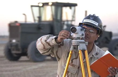
"Us land survey officer" by Brien Aho / Wikimedia Commons
Land surveying is the science of measuring and mapping Earth's surface to determine exact locations, distances, and elevations. Surveyors use specialized tools and techniques to create accurate maps that show the shape and features of the land. These maps are essential for construction projects, property boundaries, scientific research, and understanding how Earth's surface changes over time.
Traditional surveying methods have been used for thousands of years. Ancient Egyptian surveyors used ropes and simple measuring tools to rebuild property boundaries after the Nile River flooded. Modern traditional surveying relies on instruments like the theodolite, a telescope mounted on a rotating base that measures horizontal and vertical angles with great precision. Surveyors also use measuring chains or electronic distance meters to determine the space between two points. By combining angle measurements with distance measurements, surveyors can calculate exact positions on Earth's surface.
A key technique in traditional surveying is triangulation, which uses the properties of triangles to determine locations. Surveyors establish a baseline, a carefully measured line between two known points. From each end of this baseline, they measure angles to a third point. Using these angles and the baseline length, they can calculate the exact position of the third point. This process can be repeated to map large areas, with each new point serving as the corner of additional triangles.
Surveyors establish permanent reference points called benchmarks throughout a region. These are fixed markers with precisely known elevations and locations. Benchmarks serve as starting points for new surveys and help ensure consistency across different mapping projects. Many benchmarks are metal disks set in concrete or bedrock, marked with their exact elevation above sea level.
Modern surveying has been revolutionized by the Global Positioning System (GPS), a network of satellites orbiting Earth. GPS receivers on the ground pick up signals from multiple satellites simultaneously. Each satellite transmits its exact location and the precise time the signal was sent. By measuring how long signals take to arrive from different satellites, a GPS receiver can calculate its position on Earth's surface to within a few centimeters. This technology allows surveyors to determine locations much faster than traditional methods, without needing direct line of sight between measurement points.
GPS surveying uses a technique called differential GPS to achieve extremely high accuracy. One GPS receiver is placed at a benchmark with a known location, while another receiver measures the unknown location. By comparing the signals received at both locations, surveyors can correct for errors caused by atmospheric conditions and satellite positioning. This method can determine positions accurate to within one centimeter, making it suitable for scientific research, earthquake monitoring, and precision construction projects.
Both traditional and GPS surveying methods remain important today. Traditional techniques work well in areas where satellite signals are blocked by buildings, dense forests, or deep valleys. GPS excels at covering large areas quickly and measuring positions in remote locations. Many modern surveyors combine both approaches, using GPS for initial measurements and traditional methods to fill in details or verify accuracy. Together, these techniques help scientists understand Earth's surface, track how land moves during earthquakes, monitor coastal erosion, and create the detailed maps we use every day.
Interesting Fact: The GPS satellites orbit Earth at an altitude of about 20,200 kilometers and travel at speeds of roughly 14,000 kilometers per hour, completing two full orbits around our planet each day.
What is land surveying?
The science of measuring and mapping Earth's surface to determine exact locations, distances, and elevationsThe study of how rivers flood and change the landscape over timeThe process of building roads and bridges across difficult terrainThe art of drawing pictures of mountains and valleys
What tool do modern traditional surveyors use to measure horizontal and vertical angles?
A measuring chainA GPS receiverA theodoliteA rope
What is the purpose of a baseline in triangulation?
It marks the lowest point in an area being surveyedIt is a carefully measured line between two known points used to calculate the position of a third pointIt shows where surveyors should place benchmarksIt indicates the direction north on a map
According to the passage, benchmarks are permanent markers with precisely known elevations and locations.
TrueFalse
How does a GPS receiver calculate its position on Earth's surface?
By taking photographs of the land from spaceBy measuring how long signals take to arrive from different satellitesBy using a theodolite to measure angles to nearby mountainsBy comparing its elevation to sea level
What does the term 'differential GPS' refer to in the passage?
Using GPS only during daytime hoursA technique that uses two GPS receivers to compare signals and correct for errorsThe difference in elevation between two pointsA method of surveying that doesn't use satellites
Why do surveyors still use traditional methods even though GPS technology exists?
Traditional methods are always more accurate than GPSGPS is too expensive for most surveying projectsTraditional techniques work well where satellite signals are blocked by buildings, forests, or valleysTraditional methods are faster than GPS in all situations
GPS satellites complete two full orbits around Earth each day.
TrueFalse
Based on the passage, which statement best describes the relationship between traditional and GPS surveying methods?
GPS has completely replaced traditional methods in all situationsTraditional methods are outdated and no longer used by professional surveyorsBoth methods remain important and are often combined for the best resultsTraditional methods are only used when GPS equipment is broken
What can scientists learn by using surveying techniques to study Earth's surface?
How to predict the weather more accuratelyHow land moves during earthquakes and how coastal erosion occursWhere to find underground water sourcesHow to grow crops more efficiently
Perfect For:
👩🏫 Teachers
• Reading comprehension practice
• Auto-graded assessments
• Literacy skill development
👨👩👧👦 Parents
• Reading practice at home
• Comprehension improvement
• Educational reading time
🏠 Homeschoolers
• Reading curriculum support
• Independent reading practice
• Progress monitoring
Reading Features:
📖
Reading Passage
Engaging fiction or nonfiction text
❓
Comprehension Quiz
Auto-graded questions
📊
Instant Feedback
Immediate results and scoring
📄
Printable Version
Download for offline reading
🔊
Read Aloud
Voice-over with word highlighting
Reviews & Ratings
No reviews yet. Be the first to share your experience!
Related Content
Talus Slopes: Formation and Features
This earth science passage explains talus slope formation through mechanical weathering processes, aligning with NGSS MS...
MS-ESS2-1MS-ESS2-2RST.6-8.4
Biological Weathering: Types and Examples
This passage details biological weathering processes, connecting to NGSS MS-ESS2-1 (Earth's systems) and LS2.B (ecosyste...
MS-ESS2-1MS-PS1-2RST.6-8.3
Frost Wedging: How Ice Splits Rock
This passage explains frost wedging as a mechanical weathering process. Aligned with NGSS MS-ESS2-1 (Earth’s systems) a...
MS-ESS2-1MS-ESS2-2RST.6-8.3
Chemical Weathering: The Breakdown of Rocks Through Chemical Reactions
This passage explains chemical weathering processes, aligned with NGSS MS-ESS2-1 (Earth’s systems) and ESS2-2 (surface ...
MS-ESS2-1MS-ESS2-2RST.6-8.4
Limestone Caves: Nature’s Underground Wonders
This passage explains limestone cave formation through carbonation, aligned with NGSS MS-ESS2-1 (Earth’s systems) and L...
MS-ESS2-1LS2.CRST.6-8.7
The Coldest City in the World: Yakutsk
This NGSS-aligned science passage introduces middle school readers to Yakutsk, the coldest city on Earth. Students will ...
MS-ESS2-1
Igneous Rocks
This comprehensive passage introduces middle school students to igneous rocks, focusing on how these rocks form from mol...
MS-ESS2-1MS-ESS3-1
Sedimentary Rocks
This comprehensive middle school science passage introduces students to sedimentary rocks, detailing their step-by-step ...
MS-ESS2-1MS-ESS2-3MS-ESS3-1
Metamorphic Rocks
This engaging middle school science passage introduces students to the fascinating world of metamorphic rocks. Aligned w...
MS-ESS2-1MS-ESS3-1
Scientific Inquiry in Earth Science
This passage explores scientific inquiry in Earth science for grades 6-8, aligned with NGSS standards MS-ESS1-4, MS-ESS2...
MS-ESS1-4MS-ESS2-1MS-ESS3-5SEP
Contour Lines and Elevation
This passage, designed for grades 6-8 and aligned with NGSS standards MS-ESS2-2 and MS-ESS2-1, introduces students to th...
MS-ESS2-2MS-ESS2-1SEP.4SEP.8
Weathering
This comprehensive science reading passage for grades 6-8 focuses on the concept of weathering, aligning with NGSS stand...
MS-ESS2-1
Erosion
This comprehensive middle school science passage explains erosion—the process that transports weathered rock and soil fr...
MS-ESS2-1
Stream Erosion and Deposition
This middle school science passage, aligned to NGSS MS-ESS2-1, introduces students to the dynamic processes of stream er...
MS-ESS2-1
Wind Erosion and Deposition
This comprehensive science reading passage for grades 6-8 explores the processes of wind erosion and deposition, alignin...
MS-ESS2-1
Glacial Erosion and Deposition
This middle school science passage explores glacial erosion and deposition, focusing on the mechanisms by which glaciers...
MS-ESS2-1
Mass Movements
This NGSS-aligned passage introduces middle school students to the science of mass movements—gravity-driven motions of r...
MS-ESS2-1MS-ESS3-2
Soil Formation and Composition
This comprehensive middle school science passage explores soil formation and composition, perfectly aligned to NGSS stan...
MS-ESS2-1
Constructive and Destructive Forces
This middle school science passage explores how Earth's surface is constantly shaped by the interplay of constructive an...
MS-ESS2-1
Mountains and Mountain Building
This NGSS-aligned passage for grades 6-8 covers the fascinating processes that create Earth's highest landforms—mountain...