How Remote Sensing Collects Data About Earth — Reading Comprehension
Rate this
Premium Resource
Present
Present in classroom. No work saved
Assign
Classroom with student accounts, Track progress
Quick Play
No student accounts, assign with a link
Grades
6
7
8
Standards
MS-ESS2-1
PRINT+DIGITAL RESOURCE
This learning resource is available in interactive and printable formats. The interactive worksheet can be played online and assigned to students. The Printable PDF version can be downloaded and printed for completion by hand.
This 650-word informational science passage introduces middle school students (grades 6-8) to remote sensing technology and how it collects data about Earth's surface and atmosphere. Aligned with NGSS standard MS-ESS2-1, the passage explains how remote sensing works without direct contact using radar, infrared, and multispectral imaging from aircraft and satellites. Students learn how different types of electromagnetic radiation reveal features invisible to the naked eye, from underground water to forest health. The passage includes real-world applications like weather forecasting, wildfire detection, and environmental monitoring. Audio-integrated reading support helps students engage with scientific vocabulary including electromagnetic radiation, wavelength, spectral signature, and resolution. Activities include comprehension questions, writing prompts, and graphic organizers that help students understand how remote sensing technology benefits society and advances our understanding of Earth systems.
CONTENT PREVIEW
Expand content preview
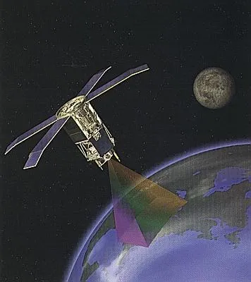
"SeaStar satellite orbit" by NASA / Wikimedia Commons.
Remote sensing is the collection of data about Earth's surface and atmosphere without making direct physical contact. Scientists use instruments on satellites and aircraft to gather information from a distance. These instruments detect different types of electromagnetic radiation that objects on Earth naturally emit or reflect. By analyzing this radiation, scientists can learn about features and conditions on our planet that would be impossible to see with the naked eye.
Remote sensing works because different materials on Earth interact with electromagnetic radiation in unique ways. When sunlight hits a forest, water body, or city, each surface absorbs some wavelengths of light and reflects others. Remote sensing instruments detect these reflected wavelengths and create images or data sets. For example, healthy plants reflect more infrared radiation than visible light, while water absorbs most infrared radiation. Scientists use these patterns, called spectral signatures, to identify what they are observing from space or aircraft.
Three main types of remote sensing technology help scientists study Earth. Radar systems send out radio waves and measure how long they take to bounce back from Earth's surface. Radar can penetrate clouds and darkness, making it useful for mapping terrain and detecting changes in land elevation. Infrared sensors detect heat energy, which helps scientists monitor forest fires, volcanic activity, and temperature differences in oceans. Multispectral imaging captures data across many different wavelengths simultaneously, allowing scientists to analyze vegetation health, water quality, and urban development patterns.
Remote sensing reveals features that human eyes cannot detect. Underground water sources create subtle temperature and moisture differences at the surface that infrared sensors can identify. Stressed or diseased trees reflect different wavelengths than healthy trees, allowing scientists to monitor forest health across vast areas. Scientists can even detect archaeological sites buried beneath soil because ancient structures affect how water and heat move through the ground. The resolution of remote sensing instruments determines how much detail they can capture, with some satellites able to detect objects as small as 30 centimeters across.
This technology provides critical information for understanding and protecting Earth's systems. Weather satellites use remote sensing to track storms and predict severe weather days in advance. Environmental scientists monitor deforestation, glacier melting, and ocean pollution using satellite data collected over time. Farmers use multispectral images to identify which parts of their fields need more water or fertilizer. During natural disasters, remote sensing helps emergency responders locate people who need help and assess damage to infrastructure.
Remote sensing has transformed how scientists collect data about Earth. Instead of visiting thousands of locations to measure conditions, researchers can analyze entire continents from space. Satellites orbit Earth continuously, providing updated information every few hours or days. This consistent monitoring allows scientists to detect changes over time and understand how Earth's systems interact. Remote sensing instruments gather objective data that helps society make informed decisions about resource management, disaster response, and environmental protection.
Interesting Fact: The Landsat satellite program has been continuously photographing Earth since 1972, creating the longest record of our planet's surface changes. Scientists can compare images from five decades to see exactly how cities, forests, and coastlines have transformed over time.
What is remote sensing?
Collecting data about Earth by making direct physical contact with surfacesCollecting data about Earth's surface and atmosphere without direct physical contactA method of traveling to distant planetsA way to communicate with satellites in space
How does remote sensing work?
By sending scientists to every location on EarthBy collecting soil samples from aircraftBy detecting electromagnetic radiation that objects emit or reflectBy measuring air pressure at ground level
What is a spectral signature?
A pattern of wavelengths that materials reflect or absorbA type of satellite orbitThe speed at which light travels through spaceA method of signing documents electronically
Which type of remote sensing can penetrate clouds and darkness?
Why can remote sensing detect underground water sources?
Water makes loud sounds undergroundWater creates visible bubbles at the surfaceWater creates subtle temperature and moisture differences at the surfaceWater changes the color of soil to bright blue
How do farmers use remote sensing technology?
To predict the weather for the next yearTo identify which parts of fields need more water or fertilizerTo communicate with other farmersTo control tractors from space
What advantage does satellite remote sensing provide compared to ground visits?
Satellites can collect soil samples more easilySatellites cost less money than walkingScientists can analyze entire continents instead of visiting thousands of locationsSatellites provide less accurate data
Remote sensing can only work during daytime when the sun is shining.
TrueFalse
The Landsat satellite program has been photographing Earth continuously since 1972.
TrueFalse
Perfect For:
👩🏫 Teachers
• Reading comprehension practice
• Auto-graded assessments
• Literacy skill development
👨👩👧👦 Parents
• Reading practice at home
• Comprehension improvement
• Educational reading time
🏠 Homeschoolers
• Reading curriculum support
• Independent reading practice
• Progress monitoring
Reading Features:
📖
Reading Passage
Engaging fiction or nonfiction text
❓
Comprehension Quiz
Auto-graded questions
📊
Instant Feedback
Immediate results and scoring
📄
Printable Version
Download for offline reading
🔊
Read Aloud
Voice-over with word highlighting
Reviews & Ratings
No reviews yet. Be the first to share your experience!
Related Content
Talus Slopes: Formation and Features
This earth science passage explains talus slope formation through mechanical weathering processes, aligning with NGSS MS...
MS-ESS2-1MS-ESS2-2RST.6-8.4
Biological Weathering: Types and Examples
This passage details biological weathering processes, connecting to NGSS MS-ESS2-1 (Earth's systems) and LS2.B (ecosyste...
MS-ESS2-1MS-PS1-2RST.6-8.3
Frost Wedging: How Ice Splits Rock
This passage explains frost wedging as a mechanical weathering process. Aligned with NGSS MS-ESS2-1 (Earth’s systems) a...
MS-ESS2-1MS-ESS2-2RST.6-8.3
Chemical Weathering: The Breakdown of Rocks Through Chemical Reactions
This passage explains chemical weathering processes, aligned with NGSS MS-ESS2-1 (Earth’s systems) and ESS2-2 (surface ...
MS-ESS2-1MS-ESS2-2RST.6-8.4
Limestone Caves: Nature’s Underground Wonders
This passage explains limestone cave formation through carbonation, aligned with NGSS MS-ESS2-1 (Earth’s systems) and L...
MS-ESS2-1LS2.CRST.6-8.7
The Coldest City in the World: Yakutsk
This NGSS-aligned science passage introduces middle school readers to Yakutsk, the coldest city on Earth. Students will ...
MS-ESS2-1
Igneous Rocks
This comprehensive passage introduces middle school students to igneous rocks, focusing on how these rocks form from mol...
MS-ESS2-1MS-ESS3-1
Sedimentary Rocks
This comprehensive middle school science passage introduces students to sedimentary rocks, detailing their step-by-step ...
MS-ESS2-1MS-ESS2-3MS-ESS3-1
Metamorphic Rocks
This engaging middle school science passage introduces students to the fascinating world of metamorphic rocks. Aligned w...
MS-ESS2-1MS-ESS3-1
Scientific Inquiry in Earth Science
This passage explores scientific inquiry in Earth science for grades 6-8, aligned with NGSS standards MS-ESS1-4, MS-ESS2...
MS-ESS1-4MS-ESS2-1MS-ESS3-5SEP
Contour Lines and Elevation
This passage, designed for grades 6-8 and aligned with NGSS standards MS-ESS2-2 and MS-ESS2-1, introduces students to th...
MS-ESS2-2MS-ESS2-1SEP.4SEP.8
Weathering
This comprehensive science reading passage for grades 6-8 focuses on the concept of weathering, aligning with NGSS stand...
MS-ESS2-1
Erosion
This comprehensive middle school science passage explains erosion—the process that transports weathered rock and soil fr...
MS-ESS2-1
Stream Erosion and Deposition
This middle school science passage, aligned to NGSS MS-ESS2-1, introduces students to the dynamic processes of stream er...
MS-ESS2-1
Wind Erosion and Deposition
This comprehensive science reading passage for grades 6-8 explores the processes of wind erosion and deposition, alignin...
MS-ESS2-1
Glacial Erosion and Deposition
This middle school science passage explores glacial erosion and deposition, focusing on the mechanisms by which glaciers...
MS-ESS2-1
Mass Movements
This NGSS-aligned passage introduces middle school students to the science of mass movements—gravity-driven motions of r...
MS-ESS2-1MS-ESS3-2
Soil Formation and Composition
This comprehensive middle school science passage explores soil formation and composition, perfectly aligned to NGSS stan...
MS-ESS2-1
Constructive and Destructive Forces
This middle school science passage explores how Earth's surface is constantly shaped by the interplay of constructive an...
MS-ESS2-1
Mountains and Mountain Building
This NGSS-aligned passage for grades 6-8 covers the fascinating processes that create Earth's highest landforms—mountain...