How Satellites Help Scientists Study Earth From Space — Reading Comprehension
Rate this
Premium Resource
Present
Present in classroom. No work saved
Assign
Classroom with student accounts, Track progress
Quick Play
No student accounts, assign with a link
Grades
6
7
8
Standards
MS-ESS2-1
PRINT+DIGITAL RESOURCE
This learning resource is available in interactive and printable formats. The interactive worksheet can be played online and assigned to students. The Printable PDF version can be downloaded and printed for completion by hand.
This comprehensive 650-word reading passage aligned with NGSS standard MS-ESS2-1 explains how Earth-orbiting satellites help scientists study our planet from space. Students will learn how satellites collect data on temperature, vegetation, ice cover, ocean color, and atmospheric gases across the entire planet. The passage describes how satellite data provides scientists with a global view of Earth's systems that ground-based instruments alone cannot provide. Audio-integrated content includes a grade-level passage, simplified differentiated version for struggling readers, Spanish translations, glossary of key scientific terms, multiple-choice comprehension questions, writing activities, and graphic organizers. Students explore real-world applications of satellite technology and understand how remote sensing enables comprehensive monitoring of Earth's interconnected systems.
CONTENT PREVIEW
Expand content preview
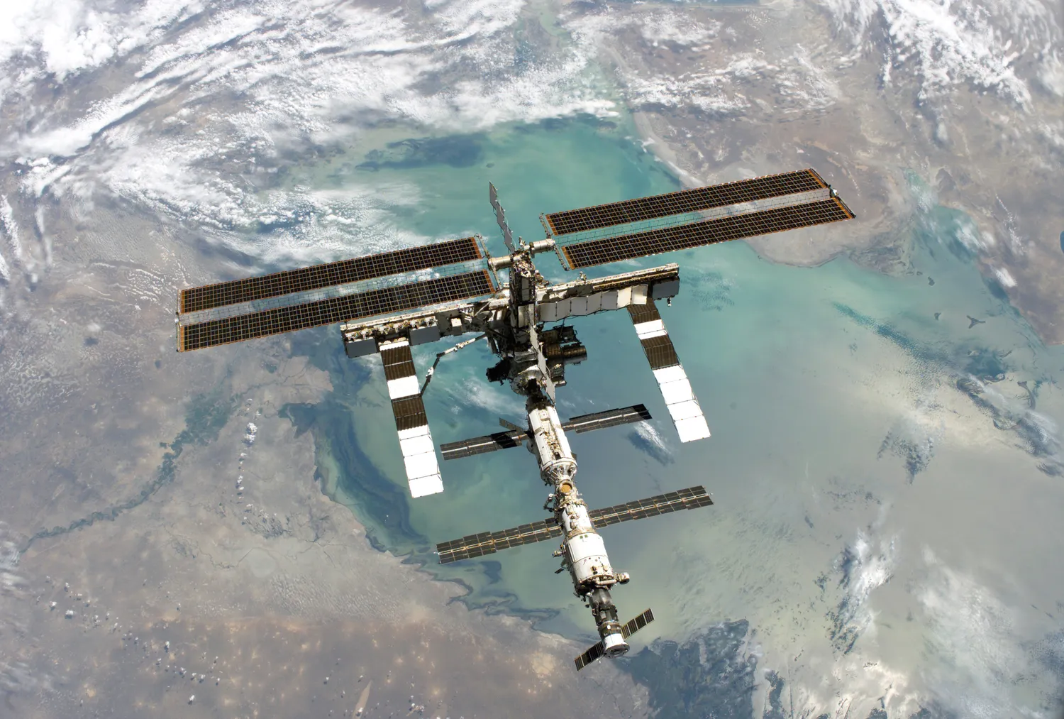
Scientists use satellites to study Earth from space. ISS Aug2005" by NASA / Wikimedia Commons
Scientists use satellites to study Earth from space. A satellite is an object that orbits around a planet. Earth-orbiting satellites carry special instruments that collect data about our planet's systems. These satellites provide a global view that ground-based instruments cannot match.
Satellites measure Earth's temperature using thermal sensors. Thermal sensors detect heat energy, called infrared radiation, that Earth's surface releases. Different surfaces release different amounts of heat. Warm ocean currents, for example, show up as bright areas on thermal images, while cooler water appears darker. Scientists use this temperature data to track weather patterns, monitor climate change, and study ocean currents around the entire planet. A single satellite can measure temperatures across thousands of miles in just one day.
Vegetation coverage is another important measurement satellites provide. Healthy plants absorb red light and reflect near-infrared light during photosynthesis. Satellites equipped with special cameras detect these light patterns. Scientists analyze the data to create maps showing where plants are growing, how healthy they are, and how vegetation changes over time. This information helps researchers track deforestation, monitor crop health, and understand how ecosystems respond to climate variations.
Satellites also monitor Earth's ice cover in polar regions and mountain ranges. Using radar technology, satellites can measure ice thickness and track changes in glaciers and ice sheets. Radar works by sending radio waves toward Earth's surface and measuring how long they take to bounce back. Some satellites use altimeters, which measure the height of ice surfaces with great precision. Scientists compare measurements taken over many years to understand how ice cover is changing. This data is critical for understanding sea level rise and global climate patterns.
Ocean color measurements reveal important information about marine ecosystems. Satellites detect the color of ocean water, which changes based on what is in it. Water containing phytoplankton—tiny plant-like organisms—appears greenish because these organisms contain chlorophyll. Clear ocean water looks deep blue. Scientists use ocean color data to track phytoplankton populations, which form the base of marine food webs and produce much of Earth's oxygen. They can also detect harmful algae blooms and monitor ocean health.
Atmospheric gases are measured by satellites using spectrometers. These instruments analyze sunlight passing through Earth's atmosphere. Different gases absorb specific wavelengths of light, creating unique patterns that scientists can identify. Satellites measure carbon dioxide, methane, ozone, and other gases that affect climate and air quality. This global atmospheric data helps scientists understand how gases move through the atmosphere and how human activities impact air composition.
The advantage of satellite observations is their ability to collect data continuously over large areas. Ground-based weather stations provide detailed local information, but they are limited to specific locations. A satellite orbiting Earth can observe entire continents and oceans repeatedly. Scientists combine satellite data with ground measurements to create comprehensive models of Earth's interconnected systems. This global perspective is essential for understanding complex environmental changes that affect the entire planet.
Interesting Fact: The Landsat program, which began in 1972, has created the longest continuous record of Earth's surface from space. Scientists can compare images from 50 years ago with current images to see exactly how our planet has changed.
What is a satellite?
An object that orbits around a planetA type of telescope on EarthA weather station in the oceanA camera used by scientists
How do thermal sensors help scientists study Earth?
They measure the weight of cloudsThey detect heat energy released from Earth's surfaceThey count the number of plantsThey measure the depth of oceans
What does the term 'infrared radiation' mean in the passage?
Visible light from the sunRadio waves from satellitesHeat energy released from surfacesHarmful radiation from space
Why do healthy plants appear differently on satellite images?
They are taller than other plantsThey absorb red light and reflect near-infrared light during photosynthesisThey produce more oxygen than unhealthy plantsThey grow faster in warm climates
How does radar technology help satellites measure ice cover?
It takes photographs of ice from aboveIt measures the temperature of ice surfacesIt sends radio waves and measures how long they take to bounce backIt counts the number of glaciers
What does ocean color reveal about marine ecosystems?
The depth of the ocean floorThe presence and health of phytoplankton populationsThe number of fish in the oceanThe temperature of ocean currents
How do spectrometers identify atmospheric gases?
By measuring air pressureBy analyzing how different gases absorb specific wavelengths of lightBy counting gas molecules in the airBy measuring wind speed
What is the main advantage of satellite observations compared to ground-based instruments?
Satellites are cheaper to operateSatellites can collect data continuously over large areasSatellites provide more detailed local informationSatellites never need maintenance
True or False: Ground-based weather stations can observe entire continents and oceans like satellites can.
TrueFalse
True or False: The Landsat program has been collecting images of Earth's surface for over 50 years.
TrueFalse
Perfect For:
👩🏫 Teachers
• Reading comprehension practice
• Auto-graded assessments
• Literacy skill development
👨👩👧👦 Parents
• Reading practice at home
• Comprehension improvement
• Educational reading time
🏠 Homeschoolers
• Reading curriculum support
• Independent reading practice
• Progress monitoring
Reading Features:
📖
Reading Passage
Engaging fiction or nonfiction text
❓
Comprehension Quiz
Auto-graded questions
📊
Instant Feedback
Immediate results and scoring
📄
Printable Version
Download for offline reading
🔊
Read Aloud
Voice-over with word highlighting
Reviews & Ratings
No reviews yet. Be the first to share your experience!
Related Content
Talus Slopes: Formation and Features
This earth science passage explains talus slope formation through mechanical weathering processes, aligning with NGSS MS...
MS-ESS2-1MS-ESS2-2RST.6-8.4
Biological Weathering: Types and Examples
This passage details biological weathering processes, connecting to NGSS MS-ESS2-1 (Earth's systems) and LS2.B (ecosyste...
MS-ESS2-1MS-PS1-2RST.6-8.3
Frost Wedging: How Ice Splits Rock
This passage explains frost wedging as a mechanical weathering process. Aligned with NGSS MS-ESS2-1 (Earth’s systems) a...
MS-ESS2-1MS-ESS2-2RST.6-8.3
Chemical Weathering: The Breakdown of Rocks Through Chemical Reactions
This passage explains chemical weathering processes, aligned with NGSS MS-ESS2-1 (Earth’s systems) and ESS2-2 (surface ...
MS-ESS2-1MS-ESS2-2RST.6-8.4
Limestone Caves: Nature’s Underground Wonders
This passage explains limestone cave formation through carbonation, aligned with NGSS MS-ESS2-1 (Earth’s systems) and L...
MS-ESS2-1LS2.CRST.6-8.7
The Coldest City in the World: Yakutsk
This NGSS-aligned science passage introduces middle school readers to Yakutsk, the coldest city on Earth. Students will ...
MS-ESS2-1
Igneous Rocks
This comprehensive passage introduces middle school students to igneous rocks, focusing on how these rocks form from mol...
MS-ESS2-1MS-ESS3-1
Sedimentary Rocks
This comprehensive middle school science passage introduces students to sedimentary rocks, detailing their step-by-step ...
MS-ESS2-1MS-ESS2-3MS-ESS3-1
Metamorphic Rocks
This engaging middle school science passage introduces students to the fascinating world of metamorphic rocks. Aligned w...
MS-ESS2-1MS-ESS3-1
Scientific Inquiry in Earth Science
This passage explores scientific inquiry in Earth science for grades 6-8, aligned with NGSS standards MS-ESS1-4, MS-ESS2...
MS-ESS1-4MS-ESS2-1MS-ESS3-5SEP
Contour Lines and Elevation
This passage, designed for grades 6-8 and aligned with NGSS standards MS-ESS2-2 and MS-ESS2-1, introduces students to th...
MS-ESS2-2MS-ESS2-1SEP.4SEP.8
Weathering
This comprehensive science reading passage for grades 6-8 focuses on the concept of weathering, aligning with NGSS stand...
MS-ESS2-1
Erosion
This comprehensive middle school science passage explains erosion—the process that transports weathered rock and soil fr...
MS-ESS2-1
Stream Erosion and Deposition
This middle school science passage, aligned to NGSS MS-ESS2-1, introduces students to the dynamic processes of stream er...
MS-ESS2-1
Wind Erosion and Deposition
This comprehensive science reading passage for grades 6-8 explores the processes of wind erosion and deposition, alignin...
MS-ESS2-1
Glacial Erosion and Deposition
This middle school science passage explores glacial erosion and deposition, focusing on the mechanisms by which glaciers...
MS-ESS2-1
Mass Movements
This NGSS-aligned passage introduces middle school students to the science of mass movements—gravity-driven motions of r...
MS-ESS2-1MS-ESS3-2
Soil Formation and Composition
This comprehensive middle school science passage explores soil formation and composition, perfectly aligned to NGSS stan...
MS-ESS2-1
Constructive and Destructive Forces
This middle school science passage explores how Earth's surface is constantly shaped by the interplay of constructive an...
MS-ESS2-1
Mountains and Mountain Building
This NGSS-aligned passage for grades 6-8 covers the fascinating processes that create Earth's highest landforms—mountain...