How Scientists Use Physical Models to Study Earth — Reading Comprehension
Rate this
Premium Resource
Present
Present in classroom. No work saved
Assign
Classroom with student accounts, Track progress
Quick Play
No student accounts, assign with a link
Grades
6
7
8
Standards
MS-ESS2-1
PRINT+DIGITAL RESOURCE
This learning resource is available in interactive and printable formats. The interactive worksheet can be played online and assigned to students. The Printable PDF version can be downloaded and printed for completion by hand.
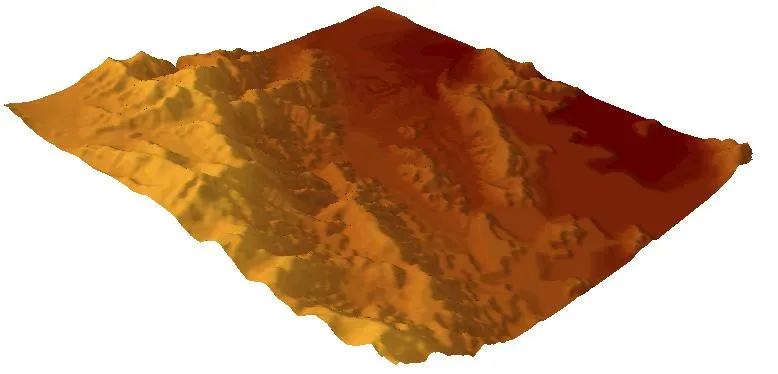
This comprehensive middle school science passage explores how scientists and engineers model landforms using both physical and digital methods. Students learn about physical models like sand tables and clay representations, as well as digital elevation models (DEMs) that use computer technology. The passage covers key concepts including scale, topography, contour lines, and elevation data. Aligned with NGSS standard MS-ESS2-1, this audio-integrated reading helps students understand how models represent Earth's surface features and support decision-making in urban planning, environmental management, and disaster preparedness. The content includes real-world applications and connects to Science and Engineering Practices of developing and using models. Students explore how both types of models have advantages and limitations, preparing them for deeper understanding of Earth systems and scientific modeling practices.
CONTENT PREVIEW
Expand content preview
Digital elevation models, or DEMs, are computer-based representations of terrain..Tolomosa River and Dam - digital elevation model by Didiervberghe / Wikimedia Commons
Scientists and engineers need ways to study Earth's surface without traveling to every location. A model is a representation of something real that helps us understand it better. Landforms are natural features of Earth's surface, such as mountains, valleys, plains, and hills. By creating models of landforms, scientists can study terrain, test ideas, and plan projects more effectively.
Physical models are three-dimensional objects that represent real landforms. One common type is a sand table, which uses sand, dirt, or other materials to build miniature versions of terrain features. Scientists might create a sand table model of a watershed to study how water flows across the land during rainfall. Clay models work similarly, allowing researchers to shape valleys, ridges, and slopes by hand. These physical models use scale, which means they maintain accurate proportions between the model and the real landform. For example, a model might use a scale where one inch represents one mile. Physical models help students and scientists visualize terrain in ways that maps alone cannot show.
Digital elevation models, or DEMs, are computer-based representations of terrain. Instead of using physical materials, DEMs store elevation data as numbers in a computer. Each point on the model has a specific height value above sea level. Scientists collect this data using satellites, aircraft with special sensors, or ground surveys. Computer programs then use this data to create visual representations of the land. DEMs can show topography, which is the arrangement of natural and artificial features on Earth's surface, including their heights and shapes.
Both physical and digital models serve important purposes in science and planning. Urban planners use DEMs to determine where to build roads and buildings by identifying flat areas and steep slopes. Environmental scientists use physical models to demonstrate how erosion affects coastlines or how landslides might occur on hillsides. Emergency managers use digital models to predict flood zones and plan evacuation routes. Engineers studying dam construction might create both types of models—a physical model to test water flow and a digital model to calculate volumes and costs.
Each type of model has advantages and limitations. Physical models are excellent for hands-on learning and can be easily modified by adding or removing material. However, they require space, materials, and time to build. Digital models can represent huge areas, store precise measurements, and be easily shared with people anywhere in the world. They also allow scientists to run simulations and test "what if" scenarios quickly. The limitation is that digital models require specialized equipment, software, and technical skills to create and interpret.
Creating accurate models requires understanding contour lines, which are lines on a map connecting points of equal elevation. When contour lines are close together, they indicate steep terrain. When they are far apart, the land is relatively flat. Both physical and digital modelers use contour line data to ensure their representations match real-world terrain. This connection between different types of models shows how scientists use multiple tools to understand the same features from different perspectives.
Interesting Fact: The most detailed digital elevation model of Earth was created by NASA's Shuttle Radar Topography Mission in 2000, which mapped about 80% of Earth's land surface with accuracy within 16 meters.
What is a model?
A representation of something real that helps us understand it betterA type of computer program used only by scientistsA physical object that must be made from sand or clayA map that shows only elevation data
Which material is commonly used to create physical models of landforms?
Plastic and metalSand and clayPaper and cardboardWood and stone
What does scale mean in the context of physical models?
The weight of the model materialsThe color scheme used in the modelThe proportion between the model and the real landform it representsThe amount of time needed to build the model
How do scientists collect elevation data for digital elevation models?
By drawing pictures of mountainsBy using satellites, aircraft with sensors, or ground surveysBy interviewing people who live in the areaBy measuring rainfall amounts
What do contour lines that are close together indicate?
Flat terrainAreas with no elevationSteep terrainWater features
Why might an engineer use both physical and digital models when studying dam construction?
To test water flow with a physical model and calculate volumes and costs with a digital modelBecause only one type of model is not accurate enoughTo make the project take longerBecause computers cannot show water movement
What is one advantage of digital elevation models compared to physical models?
They are easier for young children to understandThey can represent huge areas and be easily shared with people anywhereThey do not require any data collectionThey are always more accurate than physical models
How do emergency managers use digital models?
To predict weather patterns onlyTo design new buildingsTo predict flood zones and plan evacuation routesTo create tourist maps
Physical models require space, materials, and time to build.
TrueFalse
Digital elevation models can only represent small areas of land.
TrueFalse
Perfect For:
👩🏫 Teachers
• Reading comprehension practice
• Auto-graded assessments
• Literacy skill development
👨👩👧👦 Parents
• Reading practice at home
• Comprehension improvement
• Educational reading time
🏠 Homeschoolers
• Reading curriculum support
• Independent reading practice
• Progress monitoring
Reading Features:
📖
Reading Passage
Engaging fiction or nonfiction text
❓
Comprehension Quiz
Auto-graded questions
📊
Instant Feedback
Immediate results and scoring
📄
Printable Version
Download for offline reading
🔊
Read Aloud
Voice-over with word highlighting
Reviews & Ratings
No reviews yet. Be the first to share your experience!
Related Content
Frost Wedging: How Ice Splits Rock
This passage explains frost wedging as a mechanical weathering process. Aligned with NGSS MS-ESS2-1 (Earth’s systems) a...
MS-ESS2-1MS-ESS2-2RST.6-8.3
Limestone Caves: Nature’s Underground Wonders
This passage explains limestone cave formation through carbonation, aligned with NGSS MS-ESS2-1 (Earth’s systems) and L...
MS-ESS2-1LS2.CRST.6-8.7
Chemical Weathering: The Breakdown of Rocks Through Chemical Reactions
This passage explains chemical weathering processes, aligned with NGSS MS-ESS2-1 (Earth’s systems) and ESS2-2 (surface ...
MS-ESS2-1MS-ESS2-2RST.6-8.4
Talus Slopes: Formation and Features
This earth science passage explains talus slope formation through mechanical weathering processes, aligning with NGSS MS...
MS-ESS2-1MS-ESS2-2RST.6-8.4
Biological Weathering: Types and Examples
This passage details biological weathering processes, connecting to NGSS MS-ESS2-1 (Earth's systems) and LS2.B (ecosyste...
MS-ESS2-1MS-PS1-2RST.6-8.3
The Coldest City in the World: Yakutsk
This NGSS-aligned science passage introduces middle school readers to Yakutsk, the coldest city on Earth. Students will ...
MS-ESS2-1
Igneous Rocks
This comprehensive passage introduces middle school students to igneous rocks, focusing on how these rocks form from mol...
MS-ESS2-1MS-ESS3-1
Sedimentary Rocks
This comprehensive middle school science passage introduces students to sedimentary rocks, detailing their step-by-step ...
MS-ESS2-1MS-ESS2-3MS-ESS3-1
Metamorphic Rocks
This engaging middle school science passage introduces students to the fascinating world of metamorphic rocks. Aligned w...
MS-ESS2-1MS-ESS3-1
Scientific Inquiry in Earth Science
This passage explores scientific inquiry in Earth science for grades 6-8, aligned with NGSS standards MS-ESS1-4, MS-ESS2...
MS-ESS1-4MS-ESS2-1MS-ESS3-5SEP
Contour Lines and Elevation
This passage, designed for grades 6-8 and aligned with NGSS standards MS-ESS2-2 and MS-ESS2-1, introduces students to th...
MS-ESS2-2MS-ESS2-1SEP.4SEP.8
Weathering
This comprehensive science reading passage for grades 6-8 focuses on the concept of weathering, aligning with NGSS stand...
MS-ESS2-1
Erosion
This comprehensive middle school science passage explains erosion—the process that transports weathered rock and soil fr...
MS-ESS2-1
Stream Erosion and Deposition
This middle school science passage, aligned to NGSS MS-ESS2-1, introduces students to the dynamic processes of stream er...
MS-ESS2-1
Wind Erosion and Deposition
This comprehensive science reading passage for grades 6-8 explores the processes of wind erosion and deposition, alignin...
MS-ESS2-1
Glacial Erosion and Deposition
This middle school science passage explores glacial erosion and deposition, focusing on the mechanisms by which glaciers...
MS-ESS2-1
Mass Movements
This NGSS-aligned passage introduces middle school students to the science of mass movements—gravity-driven motions of r...
MS-ESS2-1MS-ESS3-2
Soil Formation and Composition
This comprehensive middle school science passage explores soil formation and composition, perfectly aligned to NGSS stan...
MS-ESS2-1
Constructive and Destructive Forces
This middle school science passage explores how Earth's surface is constantly shaped by the interplay of constructive an...
MS-ESS2-1
Mountains and Mountain Building
This NGSS-aligned passage for grades 6-8 covers the fascinating processes that create Earth's highest landforms—mountain...