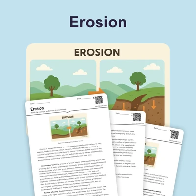
How to Read Topographic Maps — Reading Comprehension
Rate this
Premium Resource
Present
Present in classroom. No work saved
Assign
Classroom with student accounts, Track progress
Quick Play
No student accounts, assign with a link
Grades
6
7
8
Standards
MS-ESS2-1
PRINT+DIGITAL RESOURCE
This learning resource is available in interactive and printable formats. The interactive worksheet can be played online and assigned to students. The Printable PDF version can be downloaded and printed for completion by hand.
This comprehensive 600-word reading passage teaches middle school students how to read and interpret topographic maps. Students explore how contour lines represent elevation changes, slope steepness, and the three-dimensional shape of landforms on a two-dimensional surface. The passage explains key concepts including contour intervals, index contours, and how line spacing indicates terrain steepness. Real-world applications demonstrate how hikers, engineers, and scientists use these maps. Aligned with NGSS standard MS-ESS2-1, this passage develops students' ability to construct explanations based on evidence from rock formations and Earth's surface features. The content includes audio integration, Spanish translations, differentiated versions for English Language Learners, glossary terms, comprehension questions, writing activities, and graphic organizers to support diverse learners in mastering this essential earth science skill.
CONTENT PREVIEW
Expand content preview
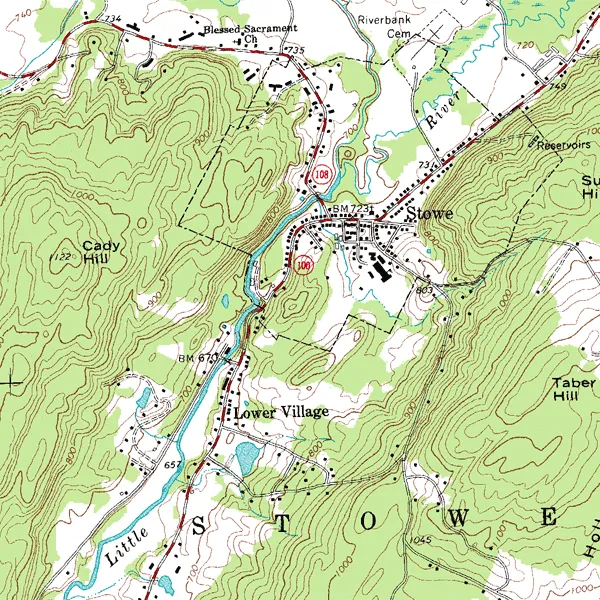
"Topographic map example" by USGS / Wikimedia Commons
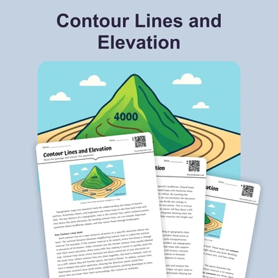
A topographic map is a special type of map that shows the shape and elevation of Earth's surface. Unlike regular maps that only show flat features like roads and buildings, topographic maps use curved lines called contour lines to represent hills, valleys, and mountains. Each contour line connects points that are at the same elevation above sea level. By learning to read these lines, you can visualize the three-dimensional landscape on a flat piece of paper.
The most important feature of a topographic map is the contour line. Every point along a single contour line has exactly the same elevation, which is the height above or below sea level. When you see contour lines close together, this indicates a steep slope. When contour lines are far apart, the slope is gentle. Think of climbing stairs: closely spaced steps make a steep staircase, while widely spaced steps create a gradual climb. The same principle applies to reading elevation changes on topographic maps.
To help map readers determine exact elevations, topographic maps include numbered lines called index contours. These are usually darker or bolder than regular contour lines and appear at regular intervals. Between index contours, you will find several lighter contour lines. The vertical distance between any two adjacent contour lines is called the contour interval. For example, if a map has a contour interval of 20 feet, each line represents an elevation change of 20 feet from the line next to it. This information is always provided in the map's legend.
Different landforms create distinctive patterns on topographic maps. A hill appears as a series of closed circles or ovals, with the smallest circle at the top representing the summit. A valley shows contour lines that form V-shapes pointing uphill, toward higher elevations. A ridge creates contour lines that form V-shapes pointing downhill. A depression, which is a low area or hollow in the ground, is shown with special contour lines that have small tick marks pointing inward toward the lowest point.
Understanding topographic maps has many practical applications. Hikers use these maps to plan routes and estimate how difficult a trail will be based on elevation changes. Engineers rely on topographic maps when designing roads, bridges, and buildings to understand the terrain they will work with. Scientists studying erosion, water flow, and geological processes use topographic maps to analyze how Earth's surface changes over time. Emergency responders use these maps to navigate unfamiliar terrain during rescue operations.
Reading topographic maps is a skill that improves with practice. Start by locating the contour interval in the map legend. Then identify index contours to establish reference elevations. Follow contour lines with your finger to trace the shape of landforms. Pay attention to line spacing to determine where slopes are steep or gentle. With experience, you will be able to visualize the three-dimensional terrain just by looking at the two-dimensional map.
Interesting Fact: The most detailed topographic maps produced by the United States Geological Survey can show elevation changes as small as 10 feet, allowing mapmakers to represent features like small hills, stream beds, and even large buildings.
What is the main purpose of contour lines on a topographic map?
To show roads and highwaysTo connect points at the same elevationTo mark state boundariesTo indicate population density
When contour lines are close together on a map, what does this indicate about the terrain?
The slope is gentle and flatThe area has many buildingsThe slope is steepThe elevation is below sea level
What is a contour interval?
The distance between two cities on a mapThe vertical distance in elevation between adjacent contour linesThe time it takes to climb a mountainThe width of a contour line
How does a hill appear on a topographic map?
As V-shapes pointing uphillAs straight parallel linesAs a series of closed circles with the smallest at the topAs dotted lines with tick marks
Which professionals use topographic maps to design roads and bridges?
TeachersEngineersArtistsMusicians
What are index contours?
Lines that show rivers and streamsDarker, numbered contour lines that help identify specific elevationsLines that mark the edge of the mapLines that show underground features
Why would a hiker use a topographic map?
To find the nearest restaurantTo plan routes and estimate trail difficulty based on elevation changesTo check the weather forecastTo locate shopping centers
If a map has widely spaced contour lines, what can you infer about the slope?
The slope is very steep and difficult to climbThe slope is gentle or gradualThere is no slope at allThe area is underwater
Topographic maps only show flat features like roads and buildings.
TrueFalse
Every point along a single contour line has exactly the same elevation.
TrueFalse
Perfect For:
👩🏫 Teachers
• Reading comprehension practice
• Auto-graded assessments
• Literacy skill development
👨👩👧👦 Parents
• Reading practice at home
• Comprehension improvement
• Educational reading time
🏠 Homeschoolers
• Reading curriculum support
• Independent reading practice
• Progress monitoring
Reading Features:
📖
Reading Passage
Engaging fiction or nonfiction text
❓
Comprehension Quiz
Auto-graded questions
📊
Instant Feedback
Immediate results and scoring
📄
Printable Version
Download for offline reading
🔊
Read Aloud
Voice-over with word highlighting
Reviews & Ratings
No reviews yet. Be the first to share your experience!
Related Content
Frost Wedging: How Ice Splits Rock
This passage explains frost wedging as a mechanical weathering process. Aligned with NGSS MS-ESS2-1 (Earth’s systems) a...
MS-ESS2-1MS-ESS2-2RST.6-8.3
Limestone Caves: Nature’s Underground Wonders
This passage explains limestone cave formation through carbonation, aligned with NGSS MS-ESS2-1 (Earth’s systems) and L...
MS-ESS2-1LS2.CRST.6-8.7
Chemical Weathering: The Breakdown of Rocks Through Chemical Reactions
This passage explains chemical weathering processes, aligned with NGSS MS-ESS2-1 (Earth’s systems) and ESS2-2 (surface ...
MS-ESS2-1MS-ESS2-2RST.6-8.4
Talus Slopes: Formation and Features
This earth science passage explains talus slope formation through mechanical weathering processes, aligning with NGSS MS...
MS-ESS2-1MS-ESS2-2RST.6-8.4
Biological Weathering: Types and Examples
This passage details biological weathering processes, connecting to NGSS MS-ESS2-1 (Earth's systems) and LS2.B (ecosyste...
MS-ESS2-1MS-PS1-2RST.6-8.3
The Coldest City in the World: Yakutsk
This NGSS-aligned science passage introduces middle school readers to Yakutsk, the coldest city on Earth. Students will ...
MS-ESS2-1
Igneous Rocks
This comprehensive passage introduces middle school students to igneous rocks, focusing on how these rocks form from mol...
MS-ESS2-1MS-ESS3-1
Sedimentary Rocks
This comprehensive middle school science passage introduces students to sedimentary rocks, detailing their step-by-step ...
MS-ESS2-1MS-ESS2-3MS-ESS3-1
Metamorphic Rocks
This engaging middle school science passage introduces students to the fascinating world of metamorphic rocks. Aligned w...
MS-ESS2-1MS-ESS3-1
Scientific Inquiry in Earth Science
This passage explores scientific inquiry in Earth science for grades 6-8, aligned with NGSS standards MS-ESS1-4, MS-ESS2...
MS-ESS1-4MS-ESS2-1MS-ESS3-5SEP
Contour Lines and Elevation
This passage, designed for grades 6-8 and aligned with NGSS standards MS-ESS2-2 and MS-ESS2-1, introduces students to th...
MS-ESS2-2MS-ESS2-1SEP.4SEP.8
Weathering
This comprehensive science reading passage for grades 6-8 focuses on the concept of weathering, aligning with NGSS stand...
MS-ESS2-1
Erosion
This comprehensive middle school science passage explains erosion—the process that transports weathered rock and soil fr...
MS-ESS2-1
Stream Erosion and Deposition
This middle school science passage, aligned to NGSS MS-ESS2-1, introduces students to the dynamic processes of stream er...
MS-ESS2-1
Wind Erosion and Deposition
This comprehensive science reading passage for grades 6-8 explores the processes of wind erosion and deposition, alignin...
MS-ESS2-1
Glacial Erosion and Deposition
This middle school science passage explores glacial erosion and deposition, focusing on the mechanisms by which glaciers...
MS-ESS2-1
Mass Movements
This NGSS-aligned passage introduces middle school students to the science of mass movements—gravity-driven motions of r...
MS-ESS2-1MS-ESS3-2
Soil Formation and Composition
This comprehensive middle school science passage explores soil formation and composition, perfectly aligned to NGSS stan...
MS-ESS2-1
Constructive and Destructive Forces
This middle school science passage explores how Earth's surface is constantly shaped by the interplay of constructive an...
MS-ESS2-1
Mountains and Mountain Building
This NGSS-aligned passage for grades 6-8 covers the fascinating processes that create Earth's highest landforms—mountain...