This learning resource is available in interactive and printable formats. The interactive worksheet can be played online and assigned to students. The Printable PDF version can be downloaded and printed for completion by hand.
This reading passage teaches elementary students about *Latitude*, one of the basic tools of geography. Students learn that lines of latitude run horizontally and measure how far a place is from the Equator. The passage explains how latitude affects climate and is used in maps and GPS tools today. It introduces key terms like *Equator*, *degrees*, and *coordinate system* in a fun and easy-to-read way. Designed for grades 2–5 and aligned with Florida standard FL.SS.2.G.1.1, this passage builds strong geography foundations and helps students understand how to find places and describe them using latitude.
CONTENT PREVIEW
Expand content preview
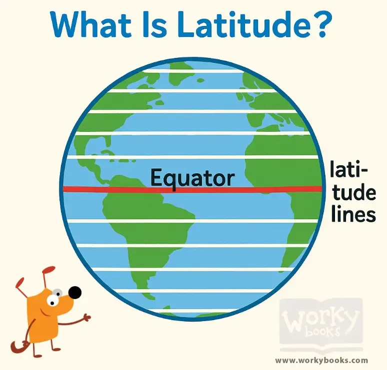
Latitude is a way to tell how far north or south a place is from the Equator. The Equator is an imaginary line that goes around the middle of the Earth, like a belt. Lines of latitude run side to side, or horizontally, across the globe. These lines help geographers and map readers find exact locations.
Each line of latitude is measured in degrees. The Equator is at 0° latitude. If you go north of the Equator, the numbers go up to 90° at the North Pole. If you go south, they go up to 90° at the South Pole. For example, Miami, Florida, is about 25° north of the Equator.
Latitude is important because it helps us understand the Earth’s climate. Places near the Equator are usually hot and tropical. Places near the poles are colder. Latitude is also used in GPS systems and maps to help people travel and learn about the world.
Today, pilots, ship captains, and even weather forecasters use latitude to do their jobs. It’s one part of a coordinate system that helps locate any spot on Earth.
Fun Fact: The word “latitude” comes from a Latin word that means “breadth” or “width” — just like the wide lines going across a map!
What is latitude used to measure?
Time zonesHow far east or west a place isHow far north or south a place isHow high a place is above sea level
What is the name of the 0° latitude line?
Prime MeridianTropic of CapricornArctic CircleEquator
How many degrees of latitude are there from the Equator to the North Pole?
25°50°90°180°
Which direction do lines of latitude run?
Up and downDiagonallyHorizontallyIn circles
Why are places near the Equator usually warm?
They are high in the mountainsThey are closer to the sunThey get more sunlight all yearThey are surrounded by deserts
What is the main idea of this passage?
The Equator is the only important line on EarthLatitude only helps pilotsLatitude tells us how tall mountains areLatitude helps us find places and understand climate
Perfect For:
👩🏫 Teachers
• Reading comprehension practice
• Auto-graded assessments
• Literacy skill development
👨👩👧👦 Parents
• Reading practice at home
• Comprehension improvement
• Educational reading time
🏠 Homeschoolers
• Reading curriculum support
• Independent reading practice
• Progress monitoring
Reading Features:
📖
Reading Passage
Engaging fiction or nonfiction text
❓
Comprehension Quiz
Auto-graded questions
📊
Instant Feedback
Immediate results and scoring
📄
Printable Version
Download for offline reading
🔊
Read Aloud
Voice-over with word highlighting
Reviews & Ratings
No reviews yet. Be the first to share your experience!
Related Content
What Is a Hemisphere?
This passage introduces elementary students to the concept of a *hemisphere*, explaining how Earth can be divided into h...
FL.SS.2.G.1.1SS.2.G.1.1
What Is a Topographic Map?
This passage introduces elementary students to the *topographic map*, a special kind of map that shows *elevation* and *...
FL.SS.2.G.1.1SS.2.G.1.2
Finding Our Way with Cardinal Directions
This engaging passage introduces elementary students to the concept of cardinal directions—north, south, east, and west....
FL.SS.2.G.1.1SS.2.G.1.3
In Between the Main Directions
This short passage teaches students about intermediate directions—northeast, southeast, southwest, and northwest—which f...
FL.SS.2.G.1.1SS.2.G.1.3
What Is a Population Map?
This passage teaches students about population maps, a kind of thematic map that shows how many people live in different...
FL.SS.2.G.1.1SS.2.G.1.3
What Is a Political Map?
This passage introduces elementary students to political maps, which show how land is divided into countries, states, an...
FL.SS.2.G.1.1SS.2.G.1.3
The Western Hemisphere
This reading passage introduces students to the *Western Hemisphere*, the half of the Earth located west of the *Prime M...
FL.SS.2.G.1.1SS.2.G.1.2
Which Continents Are in the Western Hemisphere?
This passage teaches elementary students which continents are found in the *Western Hemisphere*, including North America...
FL.SS.2.G.1.1SS.2.G.1.3
The Northern Hemisphere
This passage introduces elementary students to the *Northern Hemisphere*, the half of Earth that lies above the *Equator...
FL.SS.2.G.1.1SS.2.G.1.2
Northern and Southern Hemispheres
This passage explains the difference between the *Northern Hemisphere* and the *Southern Hemisphere*, the two halves of ...
FL.SS.2.G.1.1SS.2.G.1.3
Where Is the Equator?
This passage teaches students about the *Equator*, the imaginary line that divides Earth into the *Northern* and *Southe...
FL.SS.2.G.1.1SS.2.G.1.2
Countries on the Equator
This passage introduces students to countries located on the *Equator*, including Ecuador, Brazil, Kenya, and Indonesia....
FL.SS.2.G.1.1SS.2.G.1.3
Understanding Cardinal Directions
This engaging passage explains the concept of cardinal directions—north, south, east, and west—and their importance in n...
FL.SS.2.G.1.1SS.2.G.1.1
What Is the Prime Meridian?
This passage explains the *Prime Meridian*, the imaginary line that runs from the *North Pole* to the *South Pole* and d...
FL.SS.2.G.1.1SS.2.G.1.3
What Is the Longitude of the Prime Meridian?
This passage explains that the *Prime Meridian* is the line of *0 degrees longitude* that divides the Earth into the *Ea...
FL.SS.2.G.1.1SS.2.G.1.3
Are Directions Capitalized?
This passage teaches students about capitalization rules for direction words such as north, south, east, and west. It ex...
FL.SS.2.G.1.1SS.2.G.1.1
My Room and My House
This passage introduces young learners to the idea of personal space by starting with the room and expanding to the hous...
FL.SS.2.G.1.1SS.2.G.1.3
My Street and My Neighborhood
This reading passage helps students understand the concepts of a street and a neighborhood. It highlights how neighborho...
FL.SS.2.G.1.1SS.2.G.1.3
My Town or City
In this passage, students learn how their towns and cities are structured. It explains the role of neighborhoods, commun...
FL.SS.2.G.1.1SS.2.G.1.2
My State or Province
This geography passage teaches students about states or provinces as larger political areas made up of many towns and ci...