Monitoring and Predicting Volcanic Eruptions — Reading Comprehension
Rate this
Premium Resource
Present
Present in classroom. No work saved
Assign
Classroom with student accounts, Track progress
Quick Play
No student accounts, assign with a link
Grades
5
6
7
8
Standards
MS-ESS3-2
PRINT+DIGITAL RESOURCE
This learning resource is available in interactive and printable formats. The interactive worksheet can be played online and assigned to students. The Printable PDF version can be downloaded and printed for completion by hand.
This middle school science passage, aligned with NGSS MS-ESS3-2, explains how scientists monitor and predict volcanic eruptions using advanced technology and data analysis. Students will learn about key warning signs—such as increased earthquake activity, ground deformation, gas emissions, and temperature changes—and the sophisticated tools used to detect them, including seismographs, GPS, and satellite imagery. The passage highlights real-world case studies, like the successful evacuation before Mount Pinatubo's 1991 eruption, and discusses the challenges faced in regions with limited monitoring resources. It connects these concepts to larger scientific principles about Earth's systems and human safety. The passage is designed for grades 6-8 and features integrated audio, vocabulary support, and activities to build scientific literacy. Keywords: volcano, eruption, monitoring, prediction, seismograph, gas emissions, MS-ESS3-2.
CONTENT PREVIEW
Expand content preview
Pāhoa, Hawaii, May 19, 2018 – U.S. Geological Survey (USGS) volunteer Allan Lerner uses hydrogen sulfide (H2S) and sulfur dioxide (SO2) sensors to test the air quality after the Kīlauea volcanic eruption.Image by Grace Simoneau/FEMA / Wikimedia Commons (Public domain).
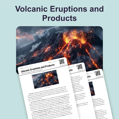
Volcanic eruptions are powerful natural events that can reshape landscapes and affect thousands of lives. Understanding how to monitor and predict these eruptions is essential for protecting people in nearby communities. Scientists use a combination of advanced technology, careful observation, and data analysis to detect the signs that a volcano may erupt. This process involves monitoring the Earth's surface and atmosphere for signals that magma is moving upward, increasing the risk of an eruption.
Warning Signs and Monitoring Tools
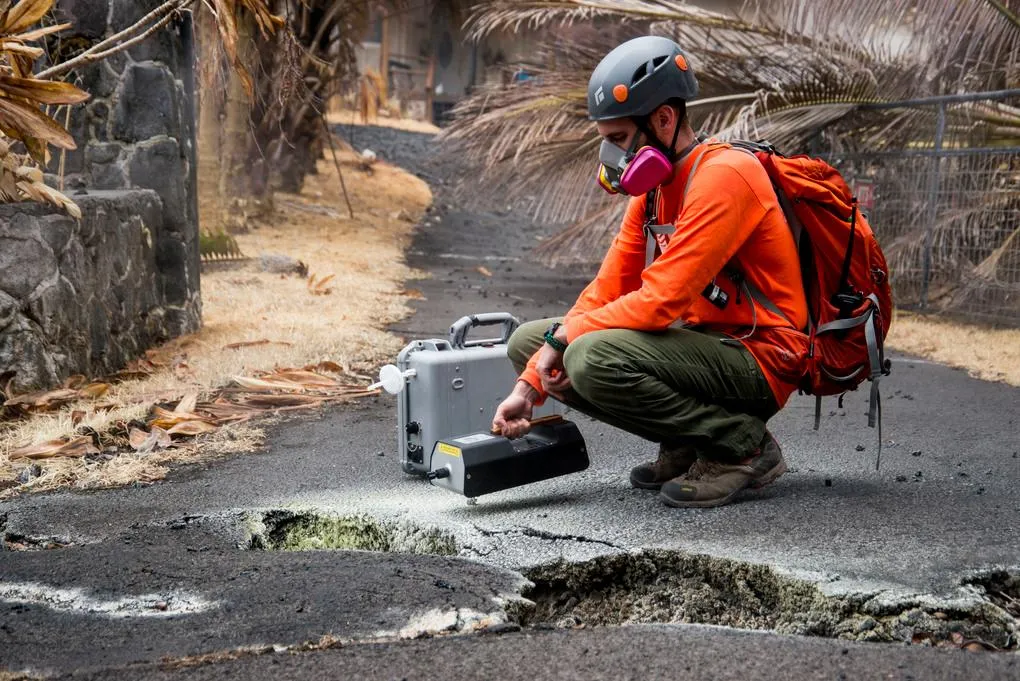
Scientists look for several warning signs that a volcano might erupt. One key sign is increased earthquake activity, which often means magma is moving beneath the surface. Instruments called seismographs record these small earthquakes. Another signal is ground deformation, where the land swells or tilts as magma accumulates. Scientists measure this with GPS units and tiltmeters. Changes in gas emissions, like a rise in sulfur dioxide, can also indicate that magma is nearing the surface. Gas analyzers collect and measure volcanic gases. Additionally, scientists use thermal imaging cameras and satellite observations to detect temperature changes and monitor large areas.
Case Studies and Real-World Applications
Accurate monitoring has saved many lives. For example, in 1991, the eruption of Mount Pinatubo in the Philippines was predicted thanks to close monitoring of seismic activity, ground swelling, and gas emissions. Over 75,000 people were evacuated, preventing thousands of deaths. However, not all countries have the resources for such monitoring. In areas without volcano observatories or modern equipment, predicting eruptions is much more difficult, which increases the risk for people living nearby.
Challenges in Prediction and Future Directions
Despite advances in technology, scientists cannot predict the exact time or size of an eruption. Volcanoes are complex systems, and similar warning signs can sometimes lead to different outcomes. To improve accuracy, scientists are developing better models that combine data from multiple sources. Volcano observatories play a crucial role by continually analyzing data and issuing alert levels that help authorities plan evacuations and reduce harm. The ongoing challenge is to make this technology and expertise available around the world.
Monitoring volcanic eruptions demonstrates how understanding Earth systems can help communities prepare for natural hazards. It also shows the importance of scientific research and international cooperation in keeping people safe.
Interesting Fact: The largest volcanic eruption of the 20th century, Mount Pinatubo in 1991, cooled the entire planet by about 0.6°C for several years due to the ash and gases released into the atmosphere.
What is one main reason scientists monitor volcanoes?
To protect people by predicting eruptionsTo find new places to build homesTo increase earthquake activityTo cool the planet
Which tool is used to measure earthquakes near volcanoes?
SeismographGas analyzerThermal cameraSatellite
What does ground deformation usually indicate at a volcano?
Magma is moving and building up under the surfaceThe volcano is shrinkingThere are fewer gases being releasedThe temperature is dropping
What is one warning sign that a volcano may erupt soon?
Sudden drop in temperatureIncrease in gas emissions like sulfur dioxideDecrease in rainfallAnimals leaving the area
What happened before the 1991 eruption of Mount Pinatubo?
Scientists detected warning signs and many people were evacuatedNo signs were detected and no one was evacuatedThe volcano was not monitored at allThe eruption cooled only the local area
What is a volcano observatory's main job?
To monitor volcanoes and issue alertsTo build houses on volcanoesTo collect plant samplesTo predict the weather
Which of the following is NOT a tool used to monitor volcanoes?
Gas analyzerTiltmeterGPSOven
Why is exact prediction of volcanic eruptions still difficult?
Volcanoes are complex and signs can lead to different outcomesScientists do not use technologyThere are no warning signs at allVolcanoes erupt on a fixed schedule
True or False: Increased earthquake activity is a warning sign that magma may be moving under a volcano.
TrueFalse
True or False: All countries have equal resources to monitor volcanoes.
TrueFalse
Perfect For:
👩🏫 Teachers
• Reading comprehension practice
• Auto-graded assessments
• Literacy skill development
👨👩👧👦 Parents
• Reading practice at home
• Comprehension improvement
• Educational reading time
🏠 Homeschoolers
• Reading curriculum support
• Independent reading practice
• Progress monitoring
Reading Features:
📖
Reading Passage
Engaging fiction or nonfiction text
❓
Comprehension Quiz
Auto-graded questions
📊
Instant Feedback
Immediate results and scoring
📄
Printable Version
Download for offline reading
🔊
Read Aloud
Voice-over with word highlighting
Reviews & Ratings
No reviews yet. Be the first to share your experience!
Related Content
Natural Disaster: Earthquake
Earthquakes occur when tectonic plates move, causing the ground to shake. Understanding earthquakes helps us prepare and...
RI.3.1RI.4.4RI.4.2RI.5.2
Volcanic Eruptions: Causes, Types, and Key Features
This science passage explains volcanic eruptions, aligned with NGSS MS-ESS3-2 (natural hazards) and ESS2-2 (Earth’s syst...
MS-ESS3-2MS-ESS2-2RST.6-8.3
Obsidian: The Natural Glass Rock
This science reading passage explores obsidian, a volcanic glass that forms when lava cools so rapidly that crystals can...
MS-ESS2-3MS-ESS3-2RST.6-8.4
Kīlauea Volcano: Hawaii’s Ever-Changing Landscape
This passage details Kīlauea's volcanic history and status, aligned with NGSS MS-ESS3-2 (natural hazards) and ESS2-3 (Ea...
MS-ESS3-2MS-ESS2-3RST.6-8.2
All About Seismometers
This informational science passage explores seismometers and their role in measuring earthquakes, designed specifically ...
MS-ESS3-2MS-ESS2-3RST.6-8.2
What Is the Difference Between Magma and Lava?
This educational reading passage explains the critical difference between magma and molten rock beneath Earth's surface ...
MS-ESS2-3MS-ESS3-2RST.6-8.4
Measuring Hurricane Intensity – The Saffir-Simpson Hurricane Wind Scale
This NGSS-aligned science reading passage explains how the Saffir-Simpson Hurricane Wind Scale is used to measure the in...
MS-ESS3-2
Tools and Technology in Earth Science
This middle school science reading passage explores the wide range of tools and technologies used in Earth science, from...
MS-ESS2-2MS-ESS3-2MS-ETS1-1MS-PS4-3
Types of Maps
This engaging science passage for grades 6-8 introduces students to the various types of maps and their uses, supporting...
MS-ESS2-2MS-ESS3-2MS-ETS1-1MS-ETS1-4
Mass Movements
This NGSS-aligned passage introduces middle school students to the science of mass movements—gravity-driven motions of r...
MS-ESS2-1MS-ESS3-2
What Causes Earthquakes?
This middle school science passage explains what causes earthquakes, focusing on the interactions between tectonic plate...
MS-ESS2-2MS-ESS3-2
Floods: Causes and Types
This middle school science passage provides a comprehensive look at floods, their causes, types, and impacts, addressing...
MS-ESS3-2
Hurricanes and Tropical Cyclones
This in-depth passage for grades 6-8 covers hurricanes and tropical cyclones, aligning with NGSS standards MS-ESS3-2 and...
MS-ESS3-2MS-ESS2-5
Hurricane Preparedness and Safety
This passage explores the science and practical strategies of hurricane preparedness and safety, designed for middle sch...
MS-ESS3-2MS-ETS1-1
Tornadoes
This informational science passage for grades 6-8 explores the science of tornadoes, aligning with NGSS standards MS-ESS...
MS-ESS3-2MS-ESS2-5
Tsunamis
This middle school science passage explores tsunamis, focusing on their causes, characteristics, and impacts. Students w...
MS-ESS3-2
Tsunami Warning and Safety
This comprehensive middle school science passage examines the systems and science behind tsunami warning and safety. Ali...
MS-ESS3-2
Earthquake Hazards and Damage
This middle school science reading passage examines the hazards and damage caused by earthquakes, aligned with NGSS MS-E...
MS-ESS3-2
Earthquake Zones and Patterns
This informational science passage introduces middle school students to the global distribution of earthquakes, focusing...
MS-ESS2-2MS-ESS3-2
Seismic Waves
This comprehensive middle school passage introduces students to seismic waves, the energy released during earthquakes. A...