Plateaus, Plains, and Basins — Reading Comprehension
Rate this
Premium Resource
Present
Present in classroom. No work saved
Assign
Classroom with student accounts, Track progress
Quick Play
No student accounts, assign with a link
Grades
5
6
7
8
Standards
MS-ESS2-1
PRINT+DIGITAL RESOURCE
This learning resource is available in interactive and printable formats. The interactive worksheet can be played online and assigned to students. The Printable PDF version can be downloaded and printed for completion by hand.
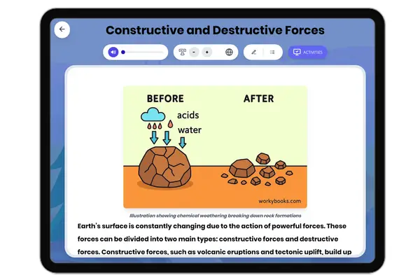
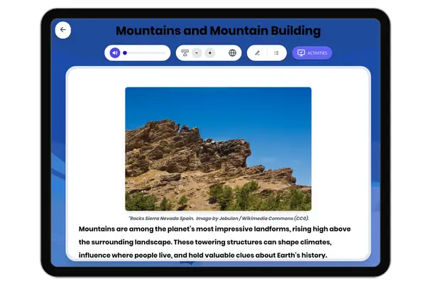
This comprehensive science reading passage for grades 6-8 introduces students to plateaus, plains, and basins—three major types of large, flat landforms found on Earth's surface. The passage meets NGSS standard MS-ESS2-1, covering the mechanisms of formation, including volcanic activity, tectonic uplift, sediment deposition, and erosion. Real-world examples such as the Columbia Plateau, Great Plains, and Great Basin illustrate these processes. Students will explore the interconnectedness of Earth's systems, analyze cause-and-effect relationships in geology, and develop vocabulary with an embedded glossary. Activities include multiple-choice questions, writing prompts, and graphic organizers, supporting both comprehension and critical thinking. The passage is available in both standard and differentiated versions, with Spanish translations to support diverse learners. Audio integration enhances accessibility, making this resource ideal for use in classroom instruction, homework, or independent study.
CONTENT PREVIEW
Expand content preview
"ISS-34 Colorado Plateau" by NASA / Wikimedia Commons (Public domain).
Plateaus, plains, and basins are some of the largest flat landforms on Earth. These features shape continents, influence ecosystems, and affect human activities. Understanding how these landforms form helps scientists explain Earth's surface changes and predict how landscapes may evolve in the future.
Formation of Plateaus Plateaus are elevated, flat regions that rise sharply above the surrounding land. Two main processes create plateaus: volcanic activity and tectonic uplift. Volcanic plateaus, such as the Columbia Plateau in the United States, form when thick layers of lava flow over large areas and cool into rock. The Columbia Plateau covers over 160,000 square kilometers, created by repeated lava floods nearly 17 million years ago. In contrast, tectonic plateaus like the Colorado Plateau or the Tibetan Plateau form when forces inside the Earth push large sections of the crust upward. These plateaus often have steep edges and may be cut by deep canyons, such as the Grand Canyon, which rivers carve over millions of years. Scientists use geological evidence and rock dating to understand these processes.
Plains: Flat, Low-Lying Areas Plains are broad, flat areas that usually lie at low elevations. There are several types: coastal plains (formed from former seafloors that have risen above sea level), interior plains (created by sediment deposited over ancient rocks), and lake plains (the floors of dried-up lakes). The Great Plains of North America stretch for over 1,800 miles and are filled with thick sediment washed down from the Rocky Mountains. These sediments can be hundreds of meters thick. Plains are important for agriculture because their soils are often rich and deep, supporting crops and grasslands. Scientists study sediments and fossils in plains to reconstruct ancient environments.
Basins: Low Areas Surrounded by Higher Land Basins are low-lying regions often surrounded by hills or mountains. Basins can form by the downwarping of the Earth's crust, the spreading apart of land (called rifting), or the erosion of soft rock layers. For example, the Great Basin in the western United States formed through crustal stretching and contains hundreds of smaller valleys and salt flats. Basins act as natural collectors for water and sediment. Some, like the Sahara Desert basins, are mostly dry but may fill with water during rare heavy rains, forming temporary lakes called playas. Researchers use satellite imagery to track basin changes and sediment buildup.
These landforms interact with Earth's water cycle, climate, and living organisms. Plateaus can affect weather patterns by blocking winds, while plains support major farming regions. Basins often become sites for lakes or deserts, depending on rainfall and drainage. Studying these features provides insight into Earth's dynamic systems and helps predict future landscape changes.
Interesting Fact: The Tibetan Plateau is sometimes called the "Roof of the World" because it averages over 4,500 meters (14,800 feet) above sea level—higher than most mountain peaks!
Which process forms the Columbia Plateau?
Volcanic activityErosion of soft rockSediment depositionRifting
What is the main characteristic of a plain?
It is elevated and flatIt is low and flatIt is surrounded by mountainsIt has many volcanoes
Which landform is described as a low area surrounded by higher land?
PlateauPlainBasinMountain
What causes tectonic plateaus to form?
Forces inside Earth push up the crustLava flows across the surfaceRivers deposit sedimentWind erosion
What does the word 'playa' mean in the context of the passage?
A high mountain peakA temporary lake in a basinA type of plateauA deep canyon
Based on the passage, why are plains important for agriculture?
They are always near volcanoesTheir soils are often rich and deepThey have many steep edgesThey are surrounded by mountains
How do basins form according to the passage?
Tectonic uplift onlyErosion, downwarping, or riftingOnly by volcanic activitySediment deposition
If a scientist finds thick layers of lava rock, what type of landform might they be studying?
Coastal plainVolcanic plateauLake plainBasin
True or False: The Great Basin is mostly formed by volcanic lava flows.
TrueFalse
True or False: Plateaus can have canyons cut into them by rivers over millions of years.
TrueFalse
Perfect For:
👩🏫 Teachers
• Reading comprehension practice
• Auto-graded assessments
• Literacy skill development
👨👩👧👦 Parents
• Reading practice at home
• Comprehension improvement
• Educational reading time
🏠 Homeschoolers
• Reading curriculum support
• Independent reading practice
• Progress monitoring
Reading Features:
📖
Reading Passage
Engaging fiction or nonfiction text
❓
Comprehension Quiz
Auto-graded questions
📊
Instant Feedback
Immediate results and scoring
📄
Printable Version
Download for offline reading
🔊
Read Aloud
Voice-over with word highlighting
Reviews & Ratings
No reviews yet. Be the first to share your experience!
Related Content
Frost Wedging: How Ice Splits Rock
This passage explains frost wedging as a mechanical weathering process. Aligned with NGSS MS-ESS2-1 (Earth’s systems) a...
MS-ESS2-1MS-ESS2-2RST.6-8.3
Limestone Caves: Nature’s Underground Wonders
This passage explains limestone cave formation through carbonation, aligned with NGSS MS-ESS2-1 (Earth’s systems) and L...
MS-ESS2-1LS2.CRST.6-8.7
Chemical Weathering: The Breakdown of Rocks Through Chemical Reactions
This passage explains chemical weathering processes, aligned with NGSS MS-ESS2-1 (Earth’s systems) and ESS2-2 (surface ...
MS-ESS2-1MS-ESS2-2RST.6-8.4
Talus Slopes: Formation and Features
This earth science passage explains talus slope formation through mechanical weathering processes, aligning with NGSS MS...
MS-ESS2-1MS-ESS2-2RST.6-8.4
Biological Weathering: Types and Examples
This passage details biological weathering processes, connecting to NGSS MS-ESS2-1 (Earth's systems) and LS2.B (ecosyste...
MS-ESS2-1MS-PS1-2RST.6-8.3
The Coldest City in the World: Yakutsk
This NGSS-aligned science passage introduces middle school readers to Yakutsk, the coldest city on Earth. Students will ...
MS-ESS2-1
Igneous Rocks
This comprehensive passage introduces middle school students to igneous rocks, focusing on how these rocks form from mol...
MS-ESS2-1MS-ESS3-1
Sedimentary Rocks
This comprehensive middle school science passage introduces students to sedimentary rocks, detailing their step-by-step ...
MS-ESS2-1MS-ESS2-3MS-ESS3-1
Metamorphic Rocks
This engaging middle school science passage introduces students to the fascinating world of metamorphic rocks. Aligned w...
MS-ESS2-1MS-ESS3-1
Scientific Inquiry in Earth Science
This passage explores scientific inquiry in Earth science for grades 6-8, aligned with NGSS standards MS-ESS1-4, MS-ESS2...
MS-ESS1-4MS-ESS2-1MS-ESS3-5SEP
Contour Lines and Elevation
This passage, designed for grades 6-8 and aligned with NGSS standards MS-ESS2-2 and MS-ESS2-1, introduces students to th...
MS-ESS2-2MS-ESS2-1SEP.4SEP.8
Weathering
This comprehensive science reading passage for grades 6-8 focuses on the concept of weathering, aligning with NGSS stand...
MS-ESS2-1
Erosion
This comprehensive middle school science passage explains erosion—the process that transports weathered rock and soil fr...
MS-ESS2-1
Stream Erosion and Deposition
This middle school science passage, aligned to NGSS MS-ESS2-1, introduces students to the dynamic processes of stream er...
MS-ESS2-1
Wind Erosion and Deposition
This comprehensive science reading passage for grades 6-8 explores the processes of wind erosion and deposition, alignin...
MS-ESS2-1
Glacial Erosion and Deposition
This middle school science passage explores glacial erosion and deposition, focusing on the mechanisms by which glaciers...
MS-ESS2-1
Mass Movements
This NGSS-aligned passage introduces middle school students to the science of mass movements—gravity-driven motions of r...
MS-ESS2-1MS-ESS3-2
Soil Formation and Composition
This comprehensive middle school science passage explores soil formation and composition, perfectly aligned to NGSS stan...
MS-ESS2-1
Constructive and Destructive Forces
This middle school science passage explores how Earth's surface is constantly shaped by the interplay of constructive an...
MS-ESS2-1
Mountains and Mountain Building
This NGSS-aligned passage for grades 6-8 covers the fascinating processes that create Earth's highest landforms—mountain...