This learning resource is available in interactive and printable formats. The interactive worksheet can be played online and assigned to students. The Printable PDF version can be downloaded and printed for completion by hand.
This comprehensive passage introduces middle school students to river landforms, focusing on how flowing water creates and shapes features such as valleys, canyons, meanders, oxbow lakes, floodplains, and deltas. The reading explains the mechanisms of erosion and deposition, supported by examples like the Grand Canyon and the Mississippi Delta. It connects these processes to the underlying geology and drainage patterns, emphasizing the importance of river systems in Earth's dynamic surface changes. The passage aligns with NGSS standard MS-ESS2-1 and is designed for grades 6-8, with a Lexile range of 750-850. Audio integration supports diverse learners. Included are a glossary, Spanish translation, differentiated version, comprehension and writing activities, and graphic organizers, making it ideal for classroom or independent study. Keywords include river landforms, erosion, deposition, delta, meander, and drainage. This resource encourages scientific thinking and real-world application, helping students connect observations to larger Earth science systems.
CONTENT PREVIEW
Expand content preview
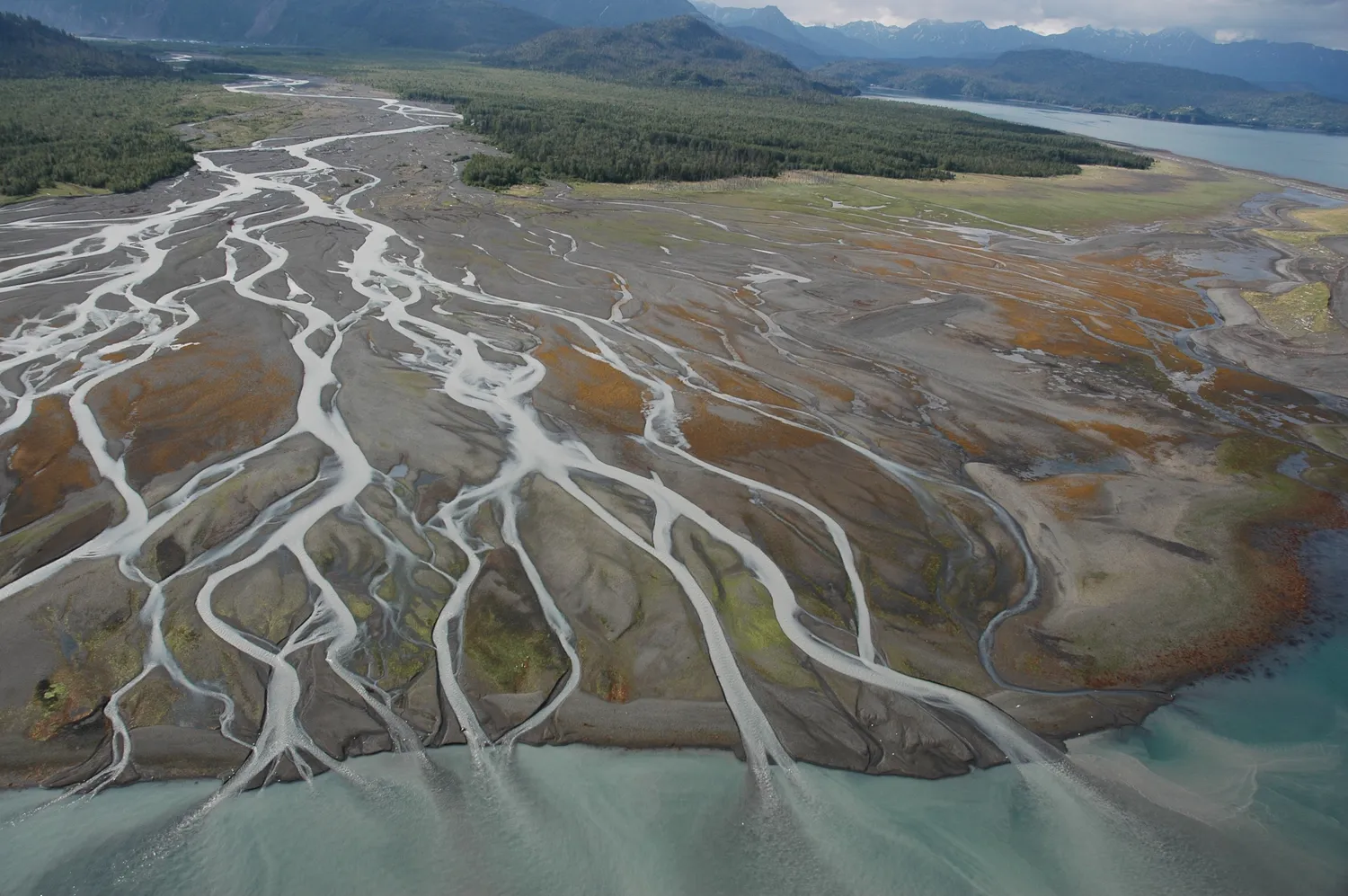
NOAA Photo Library" by Alaska ShoreZone Program NOAA/NMFS/AKFSC; Courtesy of Mandy Lindeberg, NOAA/NMFS/AKFSC. / Wikimedia Commons (Public domain).
Rivers are powerful forces that shape landscapes around the world. Flowing water carves valleys, builds up land, and constantly changes the surface of the Earth. The variety of landforms created by rivers is the result of two major processes: erosion and deposition. Scientists study these features to understand how Earth’s surface evolves and how river systems interact with their surroundings.
Erosional Landforms: Carving the Land
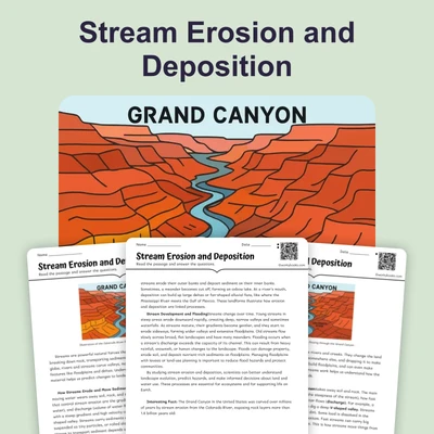
Erosion occurs when moving water picks up and carries away soil and rock. Over time, this process creates distinctive features. A V-shaped valley forms when a river rapidly cuts down into the land, creating steep sides shaped like a 'V.' In dry regions, rivers can form canyons and gorges, which are deeper and narrower than valleys. The Grand Canyon, for example, was formed over millions of years as the Colorado River eroded layers of rock at a rate of about 0.15 millimeters per year. Waterfalls and rapids often develop where hard, resistant rock layers slow erosion, causing the water to drop suddenly or flow turbulently. These features reveal information about the river's energy and the geology of the area.
Depositional Landforms: Building New Land
As the speed of a river decreases, it loses the energy needed to carry sediment. This leads to deposition—the process of dropping sediment. Floodplains form when rivers overflow their banks, spreading sediment across wide, flat areas. Levees are natural ridges along riverbanks, created as heavier sediments are deposited first. Rivers often curve back and forth, forming meanders. When a meander gets cut off from the main channel, an oxbow lake is formed. Near their mouth, rivers slow down and deposit large amounts of sediment, building deltas with different shapes: bird-foot (like the Mississippi), arcuate (fan-shaped, like the Nile), or cuspate (pointed, like the Tiber). In mountainous areas, rivers can create alluvial fans where the land flattens out suddenly.
Patterns and Systems: How Geology Shapes Rivers
The pattern a river system forms is called its drainage pattern. Dendritic patterns look like tree branches and develop in uniform rock. Trellis patterns appear where there are alternating bands of hard and soft rock. Radial patterns occur around volcanoes, while rectangular patterns form in areas with many faults or joints. The drainage divide is the boundary between different river systems, determining where water flows. These patterns provide clues about the Earth's history and the types of rocks beneath the surface.
Understanding river landforms helps us predict flooding, manage water resources, and protect habitats. Rivers interact with climate, plants, animals, and human activities, creating dynamic systems. By studying the cause-and-effect chains of erosion and deposition, scientists can forecast changes and design solutions for sustainable land use.
Interesting Fact: The Mississippi River Delta grows and shrinks as much as 40 square miles (about 100 square kilometers) each year due to changing rates of deposition and erosion!
Which two main processes shape river landforms?
Erosion and depositionEvaporation and condensationPhotosynthesis and respirationMelting and freezing
What is a V-shaped valley?
A valley with steep sides created by river downcuttingA flat area next to a riverA wide area at a river’s mouthA deep hole formed by a glacier
What is the main cause of a river forming a delta?
Deposition of sediment at the river’s mouthDowncutting by fast-moving waterMelting of ice near the riverWind erosion shaping the land
What happens when a meander is cut off from a river?
An oxbow lake is formedA canyon is createdA delta appearsA levee builds up
Which term best describes a broad, looping bend in a river?
MeanderDeltaFloodplainGorge
What does the word "erosion" mean as used in the passage?
The wearing away of soil and rock by waterThe process of plants growing by riversThe movement of air in valleysThe creation of new mountains
Why do waterfalls and rapids often form where there are hard rock layers?
Hard rock slows erosion, causing drops or turbulenceHard rock attracts more rainfallSoft rock makes the river flow straightWater cannot flow over hard rock
If a river slows down, what is most likely to happen?
It deposits more sedimentIt erodes more landIt forms more canyonsIt creates more rapids
True or False: A drainage divide is the area where two rivers join together.
TrueFalse
True or False: Alluvial fans only form at the river’s mouth where it meets the sea.
TrueFalse
Perfect For:
👩🏫 Teachers
• Reading comprehension practice
• Auto-graded assessments
• Literacy skill development
👨👩👧👦 Parents
• Reading practice at home
• Comprehension improvement
• Educational reading time
🏠 Homeschoolers
• Reading curriculum support
• Independent reading practice
• Progress monitoring
Reading Features:
📖
Reading Passage
Engaging fiction or nonfiction text
❓
Comprehension Quiz
Auto-graded questions
📊
Instant Feedback
Immediate results and scoring
📄
Printable Version
Download for offline reading
🔊
Read Aloud
Voice-over with word highlighting
Reviews & Ratings
No reviews yet. Be the first to share your experience!
Related Content
Talus Slopes: Formation and Features
This earth science passage explains talus slope formation through mechanical weathering processes, aligning with NGSS MS...
MS-ESS2-1MS-ESS2-2RST.6-8.4
Biological Weathering: Types and Examples
This passage details biological weathering processes, connecting to NGSS MS-ESS2-1 (Earth's systems) and LS2.B (ecosyste...
MS-ESS2-1MS-PS1-2RST.6-8.3
Frost Wedging: How Ice Splits Rock
This passage explains frost wedging as a mechanical weathering process. Aligned with NGSS MS-ESS2-1 (Earth’s systems) a...
MS-ESS2-1MS-ESS2-2RST.6-8.3
Chemical Weathering: The Breakdown of Rocks Through Chemical Reactions
This passage explains chemical weathering processes, aligned with NGSS MS-ESS2-1 (Earth’s systems) and ESS2-2 (surface ...
MS-ESS2-1MS-ESS2-2RST.6-8.4
Limestone Caves: Nature’s Underground Wonders
This passage explains limestone cave formation through carbonation, aligned with NGSS MS-ESS2-1 (Earth’s systems) and L...
MS-ESS2-1LS2.CRST.6-8.7
The Coldest City in the World: Yakutsk
This NGSS-aligned science passage introduces middle school readers to Yakutsk, the coldest city on Earth. Students will ...
MS-ESS2-1
Igneous Rocks
This comprehensive passage introduces middle school students to igneous rocks, focusing on how these rocks form from mol...
MS-ESS2-1MS-ESS3-1
Sedimentary Rocks
This comprehensive middle school science passage introduces students to sedimentary rocks, detailing their step-by-step ...
MS-ESS2-1MS-ESS2-3MS-ESS3-1
Metamorphic Rocks
This engaging middle school science passage introduces students to the fascinating world of metamorphic rocks. Aligned w...
MS-ESS2-1MS-ESS3-1
Scientific Inquiry in Earth Science
This passage explores scientific inquiry in Earth science for grades 6-8, aligned with NGSS standards MS-ESS1-4, MS-ESS2...
MS-ESS1-4MS-ESS2-1MS-ESS3-5SEP
Contour Lines and Elevation
This passage, designed for grades 6-8 and aligned with NGSS standards MS-ESS2-2 and MS-ESS2-1, introduces students to th...
MS-ESS2-2MS-ESS2-1SEP.4SEP.8
Weathering
This comprehensive science reading passage for grades 6-8 focuses on the concept of weathering, aligning with NGSS stand...
MS-ESS2-1
Erosion
This comprehensive middle school science passage explains erosion—the process that transports weathered rock and soil fr...
MS-ESS2-1
Stream Erosion and Deposition
This middle school science passage, aligned to NGSS MS-ESS2-1, introduces students to the dynamic processes of stream er...
MS-ESS2-1
Wind Erosion and Deposition
This comprehensive science reading passage for grades 6-8 explores the processes of wind erosion and deposition, alignin...
MS-ESS2-1
Glacial Erosion and Deposition
This middle school science passage explores glacial erosion and deposition, focusing on the mechanisms by which glaciers...
MS-ESS2-1
Mass Movements
This NGSS-aligned passage introduces middle school students to the science of mass movements—gravity-driven motions of r...
MS-ESS2-1MS-ESS3-2
Soil Formation and Composition
This comprehensive middle school science passage explores soil formation and composition, perfectly aligned to NGSS stan...
MS-ESS2-1
Constructive and Destructive Forces
This middle school science passage explores how Earth's surface is constantly shaped by the interplay of constructive an...
MS-ESS2-1
Mountains and Mountain Building
This NGSS-aligned passage for grades 6-8 covers the fascinating processes that create Earth's highest landforms—mountain...