This learning resource is available in interactive and printable formats. The interactive worksheet can be played online and assigned to students. The Printable PDF version can be downloaded and printed for completion by hand.
This comprehensive 650-word reading passage introduces middle school students to the concept of topography and how scientists describe Earth's surface features. Aligned with NGSS standard MS-ESS2-1, the passage explains three key measurements: elevation (height above sea level), slope (steepness of terrain), and relief (difference between highest and lowest points). Students learn how topographic maps use contour lines to represent three-dimensional landscapes on flat surfaces. Real-world applications include urban planning, hiking safety, and understanding natural hazards. The passage includes audio integration for enhanced accessibility, a simplified version for struggling readers, Spanish translations, glossary terms, multiple-choice questions, writing activities, and graphic organizers. Students develop skills in analyzing and interpreting data about Earth's systems while building vocabulary essential for geoscience studies.
CONTENT PREVIEW
Expand content preview
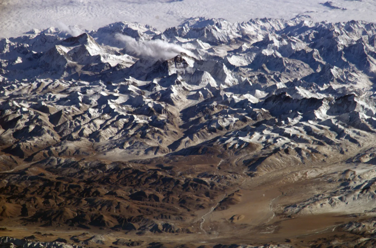
The highest point on Earth is Mount Everest at 8,849 meters above sea level,. Himalayas" by NASA / Wikimedia Commons
Topography is the study and description of the physical features and shape of Earth's surface. Scientists use topography to understand how land varies from place to place, including mountains, valleys, plains, and coastlines. By measuring and mapping these features, we can better understand Earth's systems and how they affect human activities.
Three main measurements help scientists describe topography: elevation, slope, and relief. Elevation refers to the height of a location above sea level. Sea level is the average height of the ocean's surface and serves as the zero point for measuring elevation. A mountain peak might have an elevation of 3,000 meters above sea level, while Death Valley in California has an elevation of 86 meters below sea level. Elevation affects temperature, air pressure, and the types of plants and animals that can survive in an area.
Slope describes how steep or gradual the land surface is between two points. Scientists calculate slope by measuring the change in elevation over a specific horizontal distance. A steep mountain slope changes elevation quickly over a short distance, while a gentle prairie slope changes elevation slowly over a long distance. Slope influences water drainage, soil erosion, and where people can safely build structures. Farmers consider slope when planting crops, and engineers analyze slope before constructing roads or buildings.
Relief measures the difference in elevation between the highest and lowest points in a specific area. An area with high relief has dramatic changes in elevation, like the Rocky Mountains where peaks tower thousands of meters above nearby valleys. An area with low relief has minimal elevation changes, like the flat plains of Kansas. Relief helps scientists classify landforms and understand the geological processes that shaped them.
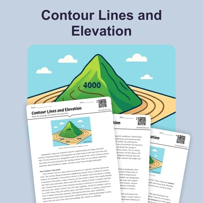
Scientists represent topography using topographic maps, which show three-dimensional land features on a flat surface. These maps use contour lines—curved lines connecting points of equal elevation. When contour lines are close together, they indicate steep slopes. When contour lines are far apart, they show gentle slopes. Reading topographic maps requires practice, but these tools provide essential information for hikers, urban planners, and emergency responders.
Understanding topography has practical applications in everyday life. City planners use topographic information to determine where to build neighborhoods and roads. Weather forecasters consider topography because mountains affect precipitation patterns and temperature. Geologists study topography to identify areas prone to landslides or flooding. Even smartphone GPS systems rely on topographic data to calculate distances and provide accurate directions.
Topography constantly changes through natural processes. Weathering breaks down rocks, erosion moves sediment from one place to another, and tectonic forces push mountains upward. These processes work over thousands or millions of years, gradually reshaping Earth's surface. By studying topography, scientists can reconstruct how landscapes looked in the past and predict how they might change in the future.
Interesting Fact: The highest point on Earth is Mount Everest at 8,849 meters above sea level, while the lowest point on land is the Dead Sea shore at 430 meters below sea level, giving Earth's land surface a relief of more than 9,200 meters.
What is topography?
The study and description of Earth's surface features and shapeThe study of ocean depths onlyThe measurement of air temperatureThe process of making paper maps
What does elevation measure?
The steepness of a hillThe height of a location above or below sea levelThe distance between two mountainsThe amount of rainfall in an area
When contour lines on a topographic map are close together, what do they indicate?
A flat areaA body of waterA steep slopeA gentle slope
What is the term for the difference between the highest and lowest points in an area?
ElevationSlopeReliefContour
Which of the following would have HIGH relief?
The flat plains of KansasA gently rolling prairieThe Rocky Mountains with peaks and valleysA coastal beach
How do scientists calculate slope?
By measuring only the highest pointBy measuring the change in elevation over a horizontal distanceBy counting contour linesBy measuring the temperature difference
Which natural process moves sediment from one place to another?
WeatheringElevationErosionRelief
Why is understanding topography important for city planners?
To predict the weather accuratelyTo determine where to build neighborhoods and roadsTo measure ocean temperaturesTo study plant growth
True or False: Sea level serves as the zero point for measuring elevation.
TrueFalse
True or False: Topography never changes once it is formed.
TrueFalse
Perfect For:
👩🏫 Teachers
• Reading comprehension practice
• Auto-graded assessments
• Literacy skill development
👨👩👧👦 Parents
• Reading practice at home
• Comprehension improvement
• Educational reading time
🏠 Homeschoolers
• Reading curriculum support
• Independent reading practice
• Progress monitoring
Reading Features:
📖
Reading Passage
Engaging fiction or nonfiction text
❓
Comprehension Quiz
Auto-graded questions
📊
Instant Feedback
Immediate results and scoring
📄
Printable Version
Download for offline reading
🔊
Read Aloud
Voice-over with word highlighting
Reviews & Ratings
No reviews yet. Be the first to share your experience!
Related Content
Frost Wedging: How Ice Splits Rock
This passage explains frost wedging as a mechanical weathering process. Aligned with NGSS MS-ESS2-1 (Earth’s systems) a...
MS-ESS2-1MS-ESS2-2RST.6-8.3
Limestone Caves: Nature’s Underground Wonders
This passage explains limestone cave formation through carbonation, aligned with NGSS MS-ESS2-1 (Earth’s systems) and L...
MS-ESS2-1LS2.CRST.6-8.7
Chemical Weathering: The Breakdown of Rocks Through Chemical Reactions
This passage explains chemical weathering processes, aligned with NGSS MS-ESS2-1 (Earth’s systems) and ESS2-2 (surface ...
MS-ESS2-1MS-ESS2-2RST.6-8.4
Talus Slopes: Formation and Features
This earth science passage explains talus slope formation through mechanical weathering processes, aligning with NGSS MS...
MS-ESS2-1MS-ESS2-2RST.6-8.4
Biological Weathering: Types and Examples
This passage details biological weathering processes, connecting to NGSS MS-ESS2-1 (Earth's systems) and LS2.B (ecosyste...
MS-ESS2-1MS-PS1-2RST.6-8.3
The Coldest City in the World: Yakutsk
This NGSS-aligned science passage introduces middle school readers to Yakutsk, the coldest city on Earth. Students will ...
MS-ESS2-1
Igneous Rocks
This comprehensive passage introduces middle school students to igneous rocks, focusing on how these rocks form from mol...
MS-ESS2-1MS-ESS3-1
Sedimentary Rocks
This comprehensive middle school science passage introduces students to sedimentary rocks, detailing their step-by-step ...
MS-ESS2-1MS-ESS2-3MS-ESS3-1
Metamorphic Rocks
This engaging middle school science passage introduces students to the fascinating world of metamorphic rocks. Aligned w...
MS-ESS2-1MS-ESS3-1
Scientific Inquiry in Earth Science
This passage explores scientific inquiry in Earth science for grades 6-8, aligned with NGSS standards MS-ESS1-4, MS-ESS2...
MS-ESS1-4MS-ESS2-1MS-ESS3-5SEP
Contour Lines and Elevation
This passage, designed for grades 6-8 and aligned with NGSS standards MS-ESS2-2 and MS-ESS2-1, introduces students to th...
MS-ESS2-2MS-ESS2-1SEP.4SEP.8
Weathering
This comprehensive science reading passage for grades 6-8 focuses on the concept of weathering, aligning with NGSS stand...
MS-ESS2-1
Erosion
This comprehensive middle school science passage explains erosion—the process that transports weathered rock and soil fr...
MS-ESS2-1
Stream Erosion and Deposition
This middle school science passage, aligned to NGSS MS-ESS2-1, introduces students to the dynamic processes of stream er...
MS-ESS2-1
Wind Erosion and Deposition
This comprehensive science reading passage for grades 6-8 explores the processes of wind erosion and deposition, alignin...
MS-ESS2-1
Glacial Erosion and Deposition
This middle school science passage explores glacial erosion and deposition, focusing on the mechanisms by which glaciers...
MS-ESS2-1
Mass Movements
This NGSS-aligned passage introduces middle school students to the science of mass movements—gravity-driven motions of r...
MS-ESS2-1MS-ESS3-2
Soil Formation and Composition
This comprehensive middle school science passage explores soil formation and composition, perfectly aligned to NGSS stan...
MS-ESS2-1
Constructive and Destructive Forces
This middle school science passage explores how Earth's surface is constantly shaped by the interplay of constructive an...
MS-ESS2-1
Mountains and Mountain Building
This NGSS-aligned passage for grades 6-8 covers the fascinating processes that create Earth's highest landforms—mountain...