Reading PassagePremium

Azimuth and Navigation Basics

Interactive passage with audio narration, comprehension questions, and printable PDF.

No ratings yet
Grade 6ScienceEnglish · SpanishInteractive · Printable
Just this resource
$1.50
One-time purchase
Best value
Unlock everything
$49.99$24.99/yr
50% off until Sept 15 — 10,000+ resources
Renews at $49.99/year.
Unlock above to use these actions

What's included

Reading passage
Audio narration
Comprehension quiz
Writing activity
Glossary & flashcards
Differentiated version
Spanish translation

Azimuth and Navigation Basics preview and details

About this printable Azimuth and Navigation Basics science reading passage, NGSS-aligned (Grade 6)

This educational resource, Azimuth and Navigation Basics, provides an engaging reading passage and activities for Grade 6 students. The passage, aligned with NGSS MS-ESS1-1, introduces core concepts of navigation, including azimuth, cardinal directions, and the use of a compass. Students will learn about the difference between true north and magnetic north and how Earth's movements influence direction. The activities include multiple-choice questions, a glossary, and short answer questions to reinforce learning and assess comprehension. Designed for a science class, this content helps students understand how we find our way and connects to broader ideas about Earth's systems. All components are audio integrated for enhanced accessibility and learning.
Written by Workybooks TeamPublished by Workybooks
Preview

Sample passage and quiz from Azimuth and Navigation Basics

Reading passage and comprehension quiz preview

Azimuth and Navigation Basics
Azimuth and Navigation
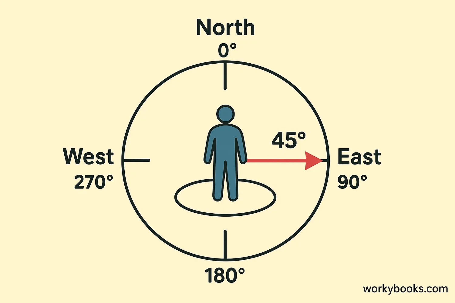
Azimuth shown with compass directions and a 45° angle

Have you ever wondered how people find their way in the wilderness or on the open ocean? It's all thanks to navigation! Navigation is the skill of planning and following a route. A key part of navigation is understanding azimuth. Azimuth is the horizontal angle or direction of a celestial body or a point on the horizon, measured clockwise from a true north baseline. Imagine standing in a circle: north is 0 degrees, east is 90 degrees, south is 180 degrees, and west is 270 degrees. Azimuth helps us give very precise directions.

To understand azimuth better, let's talk about basic directions. The four main directions are called cardinal directions: North, East, South, and West. You might use a compass to find these. A compass is a tool with a magnetic needle that always points towards the Earth's magnetic north pole. It's a very old and reliable navigation tool.

It's important to know the difference between true north and magnetic north. True north is the direction towards the geographic North Pole, which is the top of the Earth's axis of rotation. This is what maps are based on. Magnetic north, however, is where your compass needle points. The Earth's magnetic north pole is not exactly at the same place as the true North Pole, and it actually moves over time! The difference between true north and magnetic north is called magnetic declination. Navigators need to adjust for this difference to get accurate directions.


Besides a compass, ancient navigators also used the Sun and stars. For example, in the Northern Hemisphere, the North Star (Polaris) always stays in the same place in the sky, pointing almost exactly to true north. By observing the Sun's position throughout the day, people could estimate direction and time. 

The Sun rises in the east and sets in the west because of Earth's rotation, which is the spinning of Earth on its axis. This movement creates the appearance of the Sun moving across the sky, which helps with finding azimuth and direction.

Understanding azimuth and these basic navigation principles is crucial for anyone exploring or trying to understand their place on Earth. From hikers to sailors, knowing how to find your way is a vital skill for safe journeys and scientific observation.

Interesting Fact: Birds like pigeons and monarch butterflies use the Earth's magnetic field and the Sun's position to navigate during their long migrations!

Comprehension quiz (10 questions)

1. What is the degree for South?

0 degrees
90 degrees
180 degrees
270 degrees

2. What is the North Star also called?

Sirius
Polaris
Vega
Rigel

3. What does a compass needle point to?

True north
Magnetic south
Magnetic north
East

4. Why does the Sun appear to move?

Moon's orbit
Earth's rotation
Sun's movement
Magnetic declination

5. Which skill involves planning a route?

Rotation
Declination
Navigation
Azimuth

6. True north is the same as magnetic north.

True
False

7. How would Azimuth help a sailor?

Predict weather
Find precise direction
Measure ocean depth
Identify fish types

8. Why is magnetic declination important?

For star gazing
To charge compass
For accurate directions
To find true south

9. You want to hike east. Which azimuth angle should you aim for?

0 degrees
90 degrees
180 degrees
270 degrees

10. If your compass points to 30 degrees, what does that indicate?

Southwest
Northeast
Southeast
Northwest
Who it's for

Perfect for the way you teach

Teachers
  • Build comprehension skills
  • Auto-graded quiz
  • Differentiated reading
Parents
  • Read together at home
  • Improve fluency
  • Quiet reading time
Homeschoolers
  • Reading curriculum support
  • Independent practice
  • Track Lexile growth
Topics

Reviews & Ratings

No reviews yet. Be the first to share your experience!

More reading you might love

20 more
Passage
Topographic Maps - reading educational content

Topographic Maps

Reading Passage · MS-ESS2-2

$1.50
Passage
Maps and Mapping - reading educational content

Maps and Mapping

Reading Passage · MS-ESS2-2

$1.50
Passage
What Are Topographic Maps - reading educational content

What Are Topographic Maps

Reading Passage · NGSS 4-ESS2-2

$1.50
Passage
How to Read Topographic Maps - reading educational content

How to Read Topographic Maps

Reading Passage · MS-ESS2-1

$1.50
Passage
What Is Topography - reading educational content

What Is Topography

Reading Passage · MS-ESS2-1

$1.50
Passage
What Is a Topographic Map? - reading educational content

What Is a Topographic Map?

Reading Passage · FL.SS.2.G.1.1

Free
Passage
Maps and Their Uses - reading educational content

Maps and Their Uses

Reading Passage · MS-ESS2-2

$1.50
Passage
Contour Lines and Elevation - reading educational content

Contour Lines and Elevation

Reading Passage · MS-ESS2-2

$1.50
Passage
Maps Show Patterns - reading educational content

Maps Show Patterns

Reading Passage · NGSS 4-ESS2-2

$1.50
Passage
How GPS Technology Map Earth's Surface - reading educational content

How GPS Technology Map Earth's Surface

Reading Passage · MS-ESS2-1

$1.50
Passage
Map Symbols - reading educational content

Map Symbols

Reading Passage · NGSS 4-ESS2-2

$1.50
Passage
What Is a Physical Map? - reading educational content

What Is a Physical Map?

Reading Passage · 5-ESS2-1

Free
Passage
How to Read Data from Maps - reading educational content

How to Read Data from Maps

Reading Passage · NGSS 4-ESS2-2

$1.50
Passage
How Do Scientists Survey Earth's Surface - reading educational content

How Do Scientists Survey Earth's Surface

Reading Passage · MS-ESS2-1

$1.50
Passage
What Are Maps - reading educational content

What Are Maps

Reading Passage · NGSS 4-ESS2-2

$1.50
Passage
What Are Ocean Floor Maps - reading educational content

What Are Ocean Floor Maps

Reading Passage · NGSS 4-ESS2-2

$1.50
Passage
Tools and Technology in Earth Science - reading educational content

Tools and Technology in Earth Science

Reading Passage · MS-ESS2-2

$1.50
Passage
How Scientists Use Physical Models to Study Earth - reading educational content

How Scientists Use Physical Models to Study Earth

Reading Passage · MS-ESS2-1

$1.50
Passage
What Is Space Weather and How Does It Affect the Earth? - reading educational content

What Is Space Weather and How Does It Affect the Earth?

Reading Passage · MS-ESS2-2

$1.50
Passage
My Planet Earth - reading educational content

My Planet Earth

Reading Passage · FL.SS.2.G.1.1

Free
Copyright © 2026 Workybooks. Made with ♥ in California.