Reading PassagePremium

Earthquake Patterns on Earth

Interactive passage with audio narration, comprehension questions, and printable PDF.

No ratings yet
Grades 3–5ScienceElaReadingEnglish · SpanishInteractive · Printable
Aligned toNGSS 4-ESS2-2
Just this resource
$1.50
One-time purchase
Best value
Unlock everything
$49.99$29.99/yr
40% off until Aug 1 — 10,000+ resources
Renews at $49.99/year.
Unlock above to use these actions

What's included

Reading passage
Audio narration
Comprehension quiz
Writing activity
Glossary & flashcards
Differentiated version
Spanish translation

Earthquake Patterns on Earth preview and details

About this printable Earthquake Patterns on Earth science reading passage, NGSS-aligned (Grades 3-5)

This engaging 250-word reading passage introduces fourth-grade students to earthquake patterns on Earth, aligned with NGSS standard 4-ESS2-2. Students learn that earthquakes are sudden shakings of the ground that occur in specific zones rather than randomly across the planet. The passage explains how earthquakes concentrate around the edges of the Pacific Ocean and along mountain ranges, and how these patterns overlap with volcanic activity. By comparing earthquake maps and volcano maps, students discover evidence that the same underground forces cause both phenomena. The passage uses age-appropriate language and concrete examples to help students understand this foundational earth science concept. Audio-integrated features support diverse learners, while the simplified differentiated version ensures accessibility for all reading levels. Included activities feature multiple-choice questions testing recall and comprehension, writing prompts requiring students to explain earthquake patterns and apply their knowledge, and graphic organizers for comparing earthquakes and volcanoes. Spanish translations of both passage versions support English language learners. This comprehensive resource builds the background knowledge students need for hands-on investigations and class discussions about Earth's dynamic processes and geological patterns.
Written by Workybooks TeamPublished by Workybooks
Preview

Sample passage and quiz from Earthquake Patterns on Earth

Reading passage and comprehension quiz preview

Earthquake Patterns on Earth
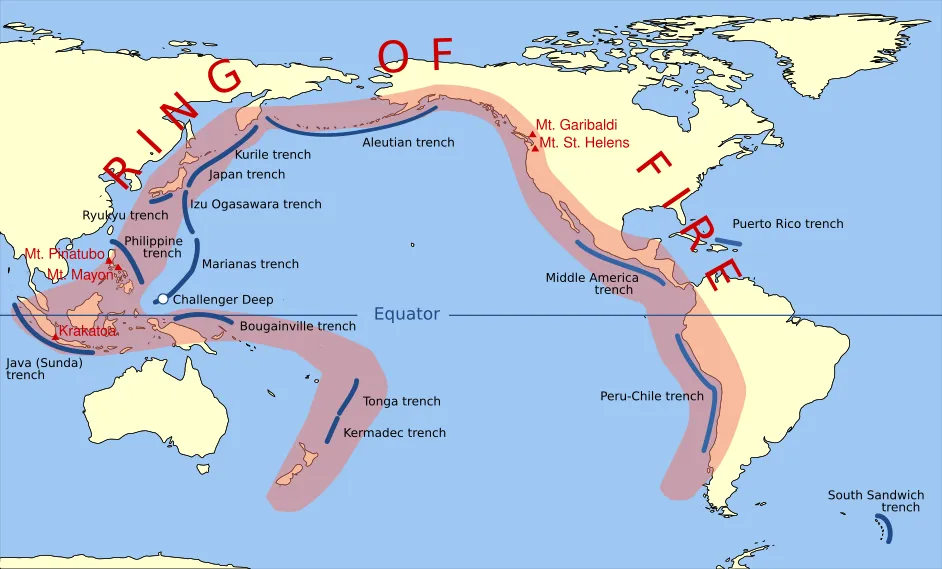
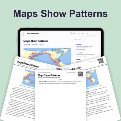
Pacific Ring of Fire

"Pacific Ring of Fire" by Gringer 23:52, 10 February 2009 (UTC) / Wikimedia Commons.

An earthquake is a sudden shaking of the ground. Earthquakes happen when pieces of Earth's surface move quickly. Understanding where earthquakes occur helps scientists predict where future earthquakes might happen and helps communities prepare to stay safe.

Earthquakes do not happen everywhere on Earth equally. Scientists have studied thousands of earthquakes and discovered clear patterns. Most earthquakes happen in specific zones, which are areas where something occurs more often. Many earthquakes occur around the edges of the Pacific Ocean. This area is sometimes called the Ring of Fire because it has many volcanoes too. Earthquakes also happen frequently along mountain ranges.

When scientists compare maps showing earthquake locations with maps showing volcano locations, they notice something important. The patterns overlap, like tracing paper placed on top of each other. Earthquakes and volcanoes occur in the same zones. This evidence, or proof, tells scientists that the same underground forces cause both earthquakes and volcanoes.

Deep beneath Earth's surface, huge pieces of rock are slowly moving. These movements create pressure, like pushing your hands together hard. When the pressure becomes too great, the ground shakes suddenly—that's an earthquake. In the same zones, hot melted rock can burst through the surface, creating volcanoes.

Interesting Fact: The largest earthquake ever recorded happened in Chile in 1960. It was so powerful that it created waves that traveled all the way across the Pacific Ocean to Japan!

Comprehension quiz (8 questions)

1. What is an earthquake?

A sudden shaking of the ground
A type of mountain range
Hot melted rock underground
A map showing volcano locations

2. Where do most earthquakes happen?

Everywhere on Earth equally
Only in the United States
In specific zones and patterns
Only under the ocean

3. What is the Ring of Fire?

A zone of forest fires
Area around Pacific Ocean edges
The center of Earth
A type of earthquake

4. Why do scientists compare earthquake and volcano maps?

To make colorful pictures
To count how many exist
To see if patterns overlap
To measure mountain heights

5. What causes earthquakes and volcanoes?

Different underground forces for each
The same underground forces
Ocean waves and wind
Scientists studying the Earth

6. What happens when underground pressure gets too great?

Mountains grow taller slowly
The ground shakes suddenly
Oceans become deeper
Volcanoes disappear completely

7. Earthquakes and volcanoes happen in completely different zones.

True
False

8. What does the word 'zone' mean?

A type of earthquake
An area where something happens often
Hot melted rock
A scientific map
Who it's for

Perfect for the way you teach

Teachers
  • Build comprehension skills
  • Auto-graded quiz
  • Differentiated reading
Parents
  • Read together at home
  • Improve fluency
  • Quiet reading time
Homeschoolers
  • Reading curriculum support
  • Independent practice
  • Track Lexile growth
Topics

Reviews & Ratings

No reviews yet. Be the first to share your experience!

More reading you might love

16 more
Passage
Map Symbols - reading educational content
Grades 3–5

Map Symbols

earth and space science · NGSS 4-ESS2-2

$1.50
Passage
Compass Rose and Scale - reading educational content
Grades 3–5

Compass Rose and Scale

earth and space science · NGSS 4-ESS2-2

$1.50
Passage
What Are Maps - reading educational content
Grades 3–5

What Are Maps

earth and space science · NGSS 4-ESS2-2

$1.50
Passage
Canyons and Valleys - reading educational content
Grades 3–5

Canyons and Valleys

earth and space science · NGSS 4-ESS2-2

$1.50
Passage
What Are Topographic Maps - reading educational content
Grades 3–5

What Are Topographic Maps

earth and space science · NGSS 4-ESS2-2

$1.50
Passage
What Are Ocean Floor Maps - reading educational content
Grades 3–5

What Are Ocean Floor Maps

earth and space science · NGSS 4-ESS2-2

$1.50
Passage
How to Read Data from Maps - reading educational content
Grades 3–5

How to Read Data from Maps

earth and space science · NGSS 4-ESS2-2

$1.50
Passage
Maps Show Patterns - reading educational content
Grades 3–5

Maps Show Patterns

earth and space science · NGSS 4-ESS2-2

$1.50
Passage
Earth's Land and Water - reading educational content
Grades 3–5

Earth's Land and Water

earth and space science · NGSS 4-ESS2-2

$1.50
Passage
What Are Mountains - reading educational content
Grades 3–5

What Are Mountains

earth and space science · NGSS 4-ESS2-2

Free
Passage
Mountain Patterns on Earth - reading educational content
Grades 3–5

Mountain Patterns on Earth

earth and space science · NGSS 4-ESS2-2

$1.50
Passage
Plains and Plateaus - reading educational content
Grades 3–5

Plains and Plateaus

earth and space science · NGSS 4-ESS2-2

$1.50
Passage
Rivers and Water Features - reading educational content
Grades 3–5

Rivers and Water Features

earth and space science · NGSS 4-ESS2-2

$1.50
Passage
Volcano Patterns on Earth - reading educational content
Grades 3–5

Volcano Patterns on Earth

earth and space science · NGSS 4-ESS2-2

Free
Passage
Ocean Trenches - reading educational content
Grades 3–5

Ocean Trenches

earth and space science · NGSS 4-ESS2-2

$1.50
Passage
How Earth's Features Connect - reading educational content
Grades 3–6

How Earth's Features Connect

earth and space science · NGSS 4-ESS2-2

$1.50
Copyright © 2026 Workybooks. Made with ♥ in California.