This learning resource is available in interactive and printable formats. The interactive worksheet can be played online and assigned to students. The Printable PDF version can be downloaded and printed for completion by hand.
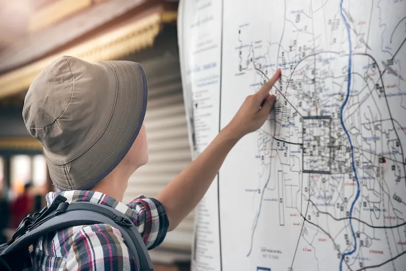
This engaging 350-word science passage introduces Grade 4-5 students to the concept of maps as flat drawings that represent places from above. Aligned with NGSS standard 4-ESS2-2, the passage explains how maps provide a bird's eye view of locations and help people navigate from one place to another. Students learn about key mapping concepts including location, directions, and spatial representation through relatable examples like zoo maps and amusement park guides. The passage uses age-appropriate analogies and clear explanations to build understanding of how maps work as tools for navigation. Audio-integrated features support diverse learners, while the conversational yet authoritative tone maintains student engagement. The content connects abstract mapping concepts to real-world applications students encounter in their daily lives, making the learning relevant and practical. Supplementary activities include comprehension questions, writing prompts, and graphic organizers that reinforce understanding of mapping concepts and their importance in helping us understand and navigate our world.
CONTENT PREVIEW
Expand content preview
Maps are flat drawings that show what places look like from above. When you look at a map, you see the world the way a bird flying high in the sky would see it. This view from above is called a bird's eye view. A bird's eye view means looking straight down at something from high up in the air. Maps help us understand where things are and how to get from one place to another.
Every map shows location, which means the position or place where something is found. Location tells you exactly where something sits in relation to other things around it. Think about your desk in your classroom. You might describe its location by saying it's near the window or in the front row. Maps work the same way, showing where buildings, streets, parks, and other places are positioned. A symbol is a small picture or shape on a map that stands for something real. For example, a small tree symbol might show where a park is located, or a tiny airplane might mark an airport.
Maps also help us find directions, which are instructions that tell us which way to go to reach a place. Most maps include a compass rose showing the four main directions: north, south, east, and west. North usually points toward the top of the map. If you want to walk from the entrance of a zoo to the elephant exhibit, the map shows you which direction to walk and which paths to follow. It's like following a recipe—each step takes you closer to your goal.
Reading a map takes practice, but it's a useful skill. You need to match what you see on the flat paper to the real three-dimensional world around you. Imagine looking down at your school from a helicopter. The buildings, playground, and parking lot would all look different from above than they do when you're standing on the ground. Maps capture that overhead view and put it on paper so you can carry it with you.
People use maps every day for many purposes. Families use maps at amusement parks to find rides and restaurants. Hikers use trail maps to explore forests safely. Even drivers use maps on their phones to navigate to new places. Scientists use maps to study Earth's surface, including mountains, rivers, and coastlines. Maps help us understand our world and explore new places with confidence.
Interesting Fact: The oldest known map was made over 4,000 years ago in ancient Babylon and was carved into a clay tablet!
What is a bird's eye view?
Looking down from high upLooking at birds in treesDrawing pictures of birdsFlying like a bird
What does location mean on a map?
The color of placesWhere something is foundHow big something isWhat time it is
What do symbols on maps represent?
Real places or thingsDecorations onlyMap makers' namesWeather conditions
Why do maps help people navigate?
They show pretty picturesThey tell interesting storiesThey show directions and locationsThey predict the future
How are maps similar to recipes?
Both are used for cookingBoth give step-by-step instructionsBoth show pictures of foodBoth are written in books
What would happen without maps at parks?
Parks would close downPeople might get lost easilyRides would stop workingAnimals would escape
Maps are flat drawings. True or false?
TrueFalse
What does navigate mean?
To draw picturesTo find your wayTo fly in the skyTo build roads
Perfect For:
👩🏫 Teachers
• Reading comprehension practice
• Auto-graded assessments
• Literacy skill development
👨👩👧👦 Parents
• Reading practice at home
• Comprehension improvement
• Educational reading time
🏠 Homeschoolers
• Reading curriculum support
• Independent reading practice
• Progress monitoring
Reading Features:
📖
Reading Passage
Engaging fiction or nonfiction text
❓
Comprehension Quiz
Auto-graded questions
📊
Instant Feedback
Immediate results and scoring
📄
Printable Version
Download for offline reading
🔊
Read Aloud
Voice-over with word highlighting
Reviews & Ratings
No reviews yet. Be the first to share your experience!
Related Content
Map Symbols
This engaging 350-word science passage introduces Grade 4-5 students to the concept of map symbols and their importance ...
NGSS 4-ESS2-2
Compass Rose
This engaging 350-word science passage introduces Grade 4-5 students to the compass rose, a fundamental map-reading tool...
NGSS 4-ESS2-2
Canyons and Valleys
This engaging 350-word science passage helps Grade 4-5 students understand how canyons and valleys form through the proc...