Premium
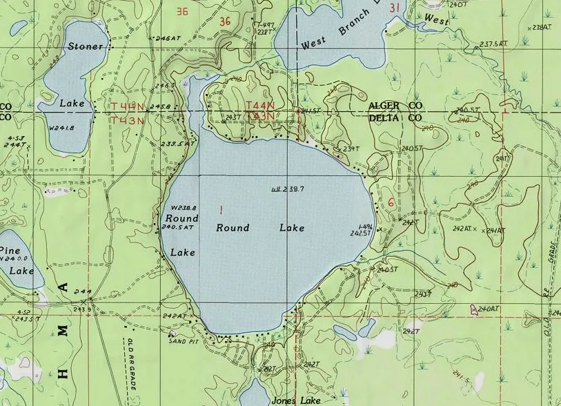
Map Symbols
Interactive passage with audio narration, comprehension questions, and printable PDF.
Just this resource
$1.50
One-time purchase
Best value
Unlock everything
$49.99$29.99/yr
40% off until Aug 1 — 6,000+ resources
Unlock above to use these actions
- Format
- Interactive (Online), Printable (PDF)
- Grades
- 345
- Subjects
- scienceela
- Standards
- NGSS 4-ESS2-2
- Languages
- English, Spanish
What's included
Reading passage
Reading comprehension
Audio narration
With word word highlighting
Comprehension quiz
Auto-graded
Writing activity
Open-ended response
Glossary & flashcards
Vocabulary practice
Differentiated version
Adapted for varied levels
Spanish translation
Bilingual support
About this reader
This engaging 350-word science passage introduces Grade 4-5 students to the concept of map symbols and their importance in map reading. Aligned with NGSS standard 4-ESS2-2, students learn how symbols are small pictures or shapes that represent real things like trees, buildings, and water. The passage explains why using symbols makes maps easier to read and less cluttered than attempting to show everything in detail. Students discover how symbols work like a secret code that helps them understand what maps are showing. The content includes real-world applications of map symbols in everyday life, from hiking trails to city planning. Audio-integrated features support diverse learners, while the passage uses concrete analogies and age-appropriate language to make abstract concepts accessible. Students explore how different types of symbols represent natural and human-made features, and learn about the map legend as a decoder for understanding these symbols. The material encourages critical thinking about how we represent three-dimensional spaces on two-dimensional surfaces.
Written by Workybooks TeamPublished by Workybooks
Preview
Sample passage and quiz content
Who it's for
Perfect for the way you teach
Teachers
- Build comprehension skills
- Auto-graded quiz
- Differentiated reading
Parents
- Read together at home
- Improve fluency
- Quiet reading time
Homeschoolers
- Reading curriculum support
- Independent practice
- Track Lexile growth
Topics
map symbolsmap readingcartographysymbols representmap legendmap keyreading mapsgeography skillsearth scienceNGSS 4-ESS2-2