How Navigation Uses Earth's Magnetic Field
Interactive passage with audio narration, comprehension questions, and printable PDF.
By completing this purchase you agree to our Terms of Use and Privacy Policy. Your subscription renews automatically until you cancel. You can cancel anytime from your account settings. All sales are final and non-refundable. Digital content is available for download in your account immediately upon purchase.
What's included
How Navigation Uses Earth's Magnetic Field preview and details
About this printable How Navigation Uses Earth's Magnetic Field science reading passage, NGSS-aligned (Grades 5-8)
Sample passage and quiz from How Navigation Uses Earth's Magnetic Field
Reading passage and comprehension quiz preview
How Navigation Uses Earth's Magnetic Field
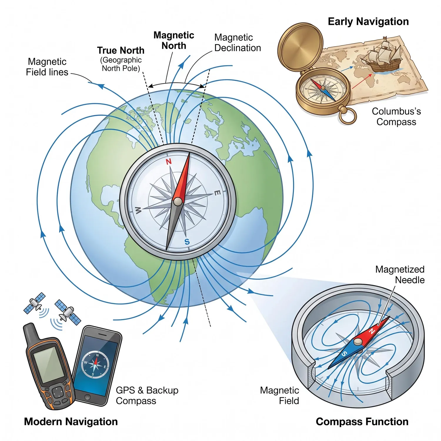
For thousands of years, people have relied on Earth's magnetic field to find their way across oceans and continents. This invisible force surrounds our planet and points in a steady direction almost everywhere on Earth. Because of this reliability, it gave sailors, explorers, and travelers a dependable method to determine their heading long before modern technology existed.
A compass is a simple tool that uses Earth's magnetic field for navigation. The compass needle is a small magnet that can spin freely. Earth's magnetic field causes the needle to align with the field lines. The needle points toward magnetic north, which is located near the North Pole. Scientists explain that this happens because opposite magnetic poles attract each other. The north-seeking end of the compass needle is drawn toward Earth's magnetic north pole.
However, navigators face an important challenge. Magnetic north is not the same location as true north, which is the geographic North Pole where all longitude lines meet. The difference between these two directions is called magnetic declination. Evidence shows that declination varies depending on where you are on Earth. In some places, the difference can be more than 20 degrees. Navigators must correct for this difference to avoid drifting off course during long journeys.
In 1492, Christopher Columbus used a magnetic compass to cross the Atlantic Ocean. His crew noticed that the compass needle's direction changed slightly as they sailed west. This observation was one of the earliest recorded examples of magnetic declination affecting navigation. Today, pilots and ship captains still use declination charts to adjust their compass readings and plot accurate courses.
Modern technology has transformed navigation through GPS satellites that provide precise location data. These satellites orbit Earth and send signals to receivers on the ground. However, compasses remain essential backup tools for hikers, sailors, and pilots. When batteries die or satellite signals vanish in remote areas, a simple magnetic compass can still guide people to safety. The invisible planetary force that has directed human exploration for ages continues to serve us well.
Interesting Fact: Earth's magnetic poles actually move slowly over time, shifting about 10 to 40 kilometers per year. Scientists track these changes to update navigation charts and ensure accurate compass readings worldwide.
Comprehension quiz (10 questions)
1. What causes a compass needle to point toward magnetic north?
2. According to the passage, why did people use Earth's magnetic field for navigation?
3. What does the term 'magnetic declination' mean in the passage?
4. What did Christopher Columbus's crew observe during their 1492 voyage?
5. Why do navigators need to correct for magnetic declination?
6. According to the passage, in some places on Earth, magnetic declination can be:
7. Why do compasses remain important even though GPS technology exists?
8. How do GPS satellites provide location information?
9. True or False: Magnetic north and true north are located at exactly the same place.
10. True or False: Earth's magnetic poles move slowly over time, shifting about 10 to 40 kilometers per year.
Perfect for the way you teach
- Build comprehension skills
- Auto-graded quiz
- Differentiated reading
- Read together at home
- Improve fluency
- Quiet reading time
- Reading curriculum support
- Independent practice
- Track Lexile growth