Latitude and Longitude
Interactive passage with audio narration, comprehension questions, and printable PDF.
What's included
Latitude and Longitude preview and details
About this printable Latitude and Longitude science reading passage, NGSS-aligned (Grades 5-8)
Sample passage and quiz from Latitude and Longitude
Reading passage and comprehension quiz preview
Latitude and Longitude
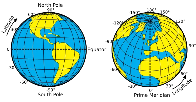
"Latitude and Longitude of the Earth" / Wikimedia Commons (CC0)
Latitude and longitude are the basic tools scientists, navigators, and mapmakers use to describe locations on Earth. Every point on our planet can be identified using these two numbers, which work like an invisible grid system. The need for a precise way to locate places became clear when explorers and scientists saw how hard it was to describe exact positions using only landmarks or directions. Today, latitude and longitude help us find everything from major cities to tiny islands and even your own house using GPS.
Earth’s Shape and the Coordinate System
Earth is not a perfect sphere. Scientists describe its shape as an oblate spheroid, meaning it is slightly flattened at the poles and bulges at the equator. This shape affects how we measure locations. Latitude measures the angular distance north or south of the equator, ranging from 0° at the equator to 90° at the poles. Important latitude lines include the equator (0°), the Tropic of Cancer (23.5°N), the Tropic of Capricorn (23.5°S), the Arctic Circle (66.5°N), the Antarctic Circle (66.5°S), and the poles (90°N and 90°S). These lines mark important climate and daylight zones. The angular distance is measured in degrees, minutes, and seconds, or in decimal degrees for more precision.
Longitude, Time, and Global Connections
Longitude measures the angular distance east or west of the Prime Meridian, which is set at 0° and runs through Greenwich, England. Longitude values go up to 180° east or west. The International Date Line, located around 180°, is where each new day begins. Longitude is crucial for measuring time zones and for navigation across oceans. For example, if you travel east or west across the world, you cross different time zones because Earth rotates 360° every 24 hours, so each 15° of longitude equals one hour of time difference. This system allows people around the world to coordinate activities despite being in different places.
Real-World Use: Locating Places and Modern Technology
By combining latitude and longitude, we can pinpoint any location on Earth. For instance, the coordinates 34°N, 118°W identify Los Angeles, California. Modern GPS (Global Positioning System) technology uses satellites to determine your exact position by calculating the time it takes for signals to reach you from at least four satellites. GPS makes it possible for smartphones, airplanes, ships, and even rescue teams to navigate accurately. This technology depends on our understanding of Earth's coordinate system and demonstrates how scientific discoveries lead to technological advances that improve our daily lives.
Understanding latitude and longitude helps us see the world as an interconnected system, where precise measurements and global cooperation are necessary for navigation, communication, and science.
Interesting Fact: The Prime Meridian was officially established at Greenwich, England, during an international conference in 1884, making it the starting point for measuring longitude worldwide.
Comprehension quiz (10 questions)
1. What is the main purpose of latitude and longitude?
2. Which line is set at 0° latitude?
3. Why is the shape of Earth described as an oblate spheroid?
4. What does longitude measure?
5. What is the main function of the International Date Line?
6. What does GPS stand for?
7. Which of these is NOT a special latitude line?
8. True or False: Longitude is measured from the equator.
9. True or False: The Prime Meridian runs through Greenwich, England.
10. If you travel 15° of longitude, how many hours of time difference does that usually make?
Perfect for the way you teach
- Build comprehension skills
- Auto-graded quiz
- Differentiated reading
- Read together at home
- Improve fluency
- Quiet reading time
- Reading curriculum support
- Independent practice
- Track Lexile growth