Reading PassagePremium

Volcanic Landforms and Features

Interactive passage with audio narration, comprehension questions, and printable PDF.

No ratings yet
Grades 5–8ScienceElaEnglish · SpanishInteractive · Printable
Aligned toMS-ESS2-2
Just this resource
$1.50
One-time purchase
Best value
Unlock everything
$49.99/yr
10,000+ resources, AI tools
Unlock above to use these actions

What's included

Reading passage
Audio narration
Comprehension quiz
Writing activity
Glossary & flashcards
Differentiated version
Spanish translation

Volcanic Landforms and Features preview and details

About this printable Volcanic Landforms and Features science reading passage, NGSS-aligned (Grades 5-8)

This engaging science passage for grades 6-8 explores the fascinating world of volcanic landforms and features, aligned with NGSS standard MS-ESS2-2. Students will discover how volcanic activity creates structures such as volcanic mountains, calderas, lava plateaus, volcanic islands, and more. The passage explains the underlying mechanisms—such as repeated eruptions, massive collapses, and lava flows—that give rise to these unique landforms. Key vocabulary terms are highlighted and defined to build science literacy, and the content is designed to emphasize systems thinking and cause-and-effect relationships. Real-world applications, such as the creation of fertile soils and geothermal features like geysers, are included. Multiple-choice questions, writing prompts, and graphic organizers support comprehension and critical thinking. Audio integration ensures accessibility for diverse learners. Ideal for middle school classrooms focused on Earth science and geology.
Written by Workybooks TeamPublished by Workybooks
Preview

Sample passage and quiz from Volcanic Landforms and Features

Reading passage and comprehension quiz preview

Volcanic Landforms and Features
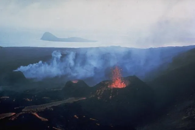
Surtsey in 1966

Lava flows issue from three small cinder cones on the newly formed island of Surtsey on August 27, 1966. Surtsey began erupting in November 1963 and soon formed a new island. 
Surtsey in 1966" by Photo by Richie Williams, 1966 (U.S. Geological Survey). / Wikimedia Commons (Public domain).

Volcanic activity is a powerful force that constantly shapes Earth's surface. Around the world, landforms created by volcanoes can be seen from towering mountains to wide, flat plateaus. These structures are evidence of how internal energy from Earth's mantle reaches the surface and interacts with the atmosphere and hydrosphere. By studying volcanic landforms, scientists learn about Earth's dynamic processes, hazards, and resources.

How Volcanic Landforms Form

Most volcanic landforms result from the movement of molten rock, called magma, from beneath the surface to above ground. When magma erupts, it is called lava. Repeated eruptions of lava and ash can build up volcanic mountains, such as Mt. Fuji in Japan. At the summit, a bowl-shaped crater often forms where eruptions occur. In rare cases, a massive eruption empties the magma chamber below, causing the ground to collapse and form a huge depression called a caldera. For example, Crater Lake in Oregon fills a caldera nearly 10 kilometers wide. Some eruptions produce lava plateaus, which are broad, flat regions created when extremely fluid lava flows over large areas, like the Columbia Plateau in the United States. Over time, volcanic activity can build entire islands in the ocean, such as the Hawaiian Islands or Iceland, as lava accumulates above sea level.

Other Volcanic Features and Interactions

Not all volcanic features are above ground. As magma cools beneath the surface, it can form plutonic features, such as batholiths, dikes, and sills. Over millions of years, erosion may expose these structures at the surface. Volcanic necks, like Ship Rock in New Mexico, are the hard remnants of magma that solidified inside a volcano and were left standing after softer rock eroded away. Volcanic activity also interacts with groundwater. In places like Yellowstone National Park, groundwater heated by magma creates hot springs and geysers—Old Faithful erupts water over 30 meters into the air every 90 minutes. Volcanic soils, formed from mineral-rich ash and lava, are extremely fertile and support agriculture in many regions.

Importance and Broader Implications

Volcanic landforms demonstrate how Earth’s internal energy drives surface changes. These features can create hazards, such as eruptions and landslides, but also provide benefits. Fertile volcanic soils support crops for millions of people. Geothermal energy from volcanic regions is harnessed for electricity and heating in countries like Iceland. Studying volcanic landforms helps scientists understand the past and predict future changes, connecting to the broader principles of Earth system science and plate tectonics.

Interesting Fact: The island of Surtsey off the coast of Iceland was formed in 1963 by an underwater eruption, allowing scientists to watch an entire island develop from scratch.

Comprehension quiz (10 questions)

1. What is the primary process that creates volcanic landforms?

Movement of magma from beneath Earth's surface
Erosion by wind and water
Freezing and melting of glaciers
Growth of plant roots
Formation of clouds

2. Which landform is created when a massive volcanic eruption causes the ground to collapse?

Crater
Caldera
Volcanic mountain
Lava plateau

3. According to the passage, what do volcanic soils provide for people?

Hazards for travelers
Fertile land for growing crops
Areas for building cities
Sources of drinking water

4. What is a volcanic neck, as described in the passage?

A bowl-shaped depression at the volcano's summit
A flat area formed by lava flows
A hard plug of magma left after softer rock erodes away
An island formed from volcanic eruptions

5. Which term best describes magma after it erupts onto the surface?

Plutonic feature
Lava
Geyser
Crater

6. In the passage, what is a caldera?

A hard plug of old magma
A large depression from ground collapse after a massive eruption
A flat-topped mountain
A volcanic soil type

7. Why do volcanic islands form in the ocean?

Because of underwater earthquakes
Because lava builds up above sea level after repeated eruptions
Because wind carries soil to the sea
Because glaciers melt rapidly

8. How are geysers related to volcanic activity?

They are formed by wind blowing over mountains
They are created when groundwater is heated by magma underground
They are a type of volcanic island
They are formed from lava flows

9. True or False: Lava plateaus are formed from repeated layers of lava spreading over a large area.

True
False

10. True or False: All volcanic landforms create dangerous environments for humans.

True
False
Who it's for

Perfect for the way you teach

Teachers
  • Build comprehension skills
  • Auto-graded quiz
  • Differentiated reading
Parents
  • Read together at home
  • Improve fluency
  • Quiet reading time
Homeschoolers
  • Reading curriculum support
  • Independent practice
  • Track Lexile growth
Topics

Reviews & Ratings

No reviews yet. Be the first to share your experience!

More reading you might love

20 more
Passage
Frost Wedging: How Ice Splits Rock - reading educational content
Grades 5–8

Frost Wedging: How Ice Splits Rock

earth and space science · MS-ESS2-1

$1.50
Passage
Chemical Weathering: The Breakdown of Rocks Through Chemical Reactions - reading educational content
Grades 5–8

Chemical Weathering: The Breakdown of Rocks Through Chemical Reactions

earth and space science · MS-ESS2-1

Free
Passage
Talus Slopes: Formation and Features - reading educational content
Grades 5–8

Talus Slopes: Formation and Features

science · MS-ESS2-1

Free
Passage
Stratigraphic Columns: Decoding Earth’s Geological Layers - reading educational content
Grades 5–8

Stratigraphic Columns: Decoding Earth’s Geological Layers

science · MS-ESS2-2

Free
Passage
What Is Space Weather and How Does It Affect the Earth? - reading educational content
Grades 3–7

What Is Space Weather and How Does It Affect the Earth?

earth and space science · MS-ESS2-2

$1.50
Passage
When Was The Last Ice Age - reading educational content
Grade 6

When Was The Last Ice Age

earth and space science · MS-ESS2-2

$1.50
Passage
Tools and Technology in Earth Science - reading educational content
Grades 5–8

Tools and Technology in Earth Science

science · MS-ESS2-2

$1.50
Passage
Maps and Mapping - reading educational content
Grades 5–8

Maps and Mapping

earth and space science · MS-ESS2-2

$1.50
Passage
Latitude and Longitude - reading educational content
Grades 5–8

Latitude and Longitude

earth and space science · MS-ESS2-2

$1.50
Passage
Topographic Maps - reading educational content
Grades 5–8

Topographic Maps

earth and space science · MS-ESS2-2

$1.50
Passage
Contour Lines and Elevation - reading educational content
Grades 5–8

Contour Lines and Elevation

earth and space science · MS-ESS2-2

$1.50
Passage
Maps and Their Uses - reading educational content
Grades 5–8

Maps and Their Uses

earth and space science · MS-ESS2-2

$1.50
Passage
Mountains and Mountain Building - reading educational content
Grades 5–8

Mountains and Mountain Building

earth and space science · MS-ESS2-1

$1.50
Passage
Earth's Interior - reading educational content
Grades 5–8

Earth's Interior

earth and space science · MS-ESS2-1

$1.50
Passage
Continental Drift Theory - reading educational content
Grades 5–8

Continental Drift Theory

earth and space science · MS-ESS2-2

Free
Passage
Seafloor Spreading - reading educational content
Grades 5–8

Seafloor Spreading

science · MS-ESS2-2

$1.50
Passage
Theory of Plate Tectonics - reading educational content
Grades 5–8

Theory of Plate Tectonics

earth and space science · MS-ESS2-2

$1.50
Passage
Divergent Plate Boundaries - reading educational content
Grades 5–8

Divergent Plate Boundaries

earth and space science · MS-ESS2-2

$1.50
Passage
Convergent Plate Boundaries - reading educational content
Grades 5–8

Convergent Plate Boundaries

earth and space science · MS-ESS2-2

$1.50
Passage
Transform Plate Boundaries - reading educational content
Grades 5–8

Transform Plate Boundaries

earth and space science · MS-ESS2-2

$1.50
Copyright © 2026 Workybooks. Made with ♥ in California.