Geographic Information Systems (GIS) — Reading Comprehension
Rate this
Premium Resource
Present
Present in classroom. No work saved
Assign
Classroom with student accounts, Track progress
Quick Play
No student accounts, assign with a link
Grades
5
6
7
8
Standards
MS-ESS3-3
MS-ETS1-1
MS-ETS1-2
MS-ETS1-3
MS-ETS1-4
MS-PS3-3
SEP4
SEP6
PRINT+DIGITAL RESOURCE
This learning resource is available in interactive and printable formats. The interactive worksheet can be played online and assigned to students. The Printable PDF version can be downloaded and printed for completion by hand.
This engaging middle school science passage introduces students to Geographic Information Systems (GIS), aligning with NGSS science standards and supporting science practices. Students learn how GIS is a digital tool for capturing, storing, analyzing, and displaying geographically referenced data. The text explains key mechanisms, such as overlaying different data layers (like roads, rivers, and population), and describes spatial analysis to answer questions about patterns and changes in the environment. Real-world applications, including urban planning, emergency response, epidemiology, and natural resource management, provide relevance and context. The passage covers GIS data types (vector and raster), connections to GPS field collection, and highlights STEM careers like GIS analyst and urban planner. Activities include a glossary, multiple-choice quiz, writing prompts, graphic organizers, and Spanish translations. Audio integration is available for all content, ensuring accessibility and engagement for diverse learners.
CONTENT PREVIEW
Expand content preview
Geographic information system
Geographic Information Systems (GIS) are transforming how people understand and solve problems related to location and space. In recent years, cities have faced challenges with traffic congestion, disaster response, and environmental management. Scientists, city planners, and businesses use GIS to analyze data and make informed decisions. The ability to map and study patterns across different places is essential for understanding our world.
How GIS Works: Mapping and Analyzing Data 
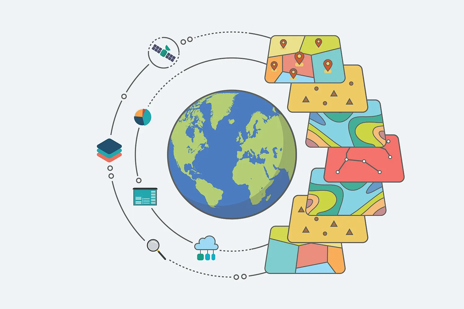
GIS is a computer-based system for capturing, storing, analyzing, and displaying data connected to specific locations on Earth. GIS uses data layers, such as roads, rivers, population, and elevation, to create a digital map. Each layer represents a different type of information. When these layers are combined, GIS can answer questions like, "What is at this location?" and "Where do certain features occur together?" GIS uses spatial analysis to find patterns and relationships, such as which neighborhoods have the highest risk of flooding. Data in GIS can be vector (points, lines, polygons) or raster (grids or pixels) formats. For example, a vector layer might show the outline of a city park, while a raster layer could display temperature across a region.
Applications and Real-World Examples GIS is used in many fields. Urban planners rely on GIS to determine the best locations for new schools based on population trends and road access. Emergency response teams use GIS to map hazards, predict evacuation routes, and deliver aid more effectively during natural disasters. In epidemiology, GIS helps scientists track the spread of diseases, such as mapping COVID-19 cases to identify hotspots. Businesses use GIS to choose locations for new stores by studying customer and competitor locations. GIS data can be collected in the field using Global Positioning System (GPS) devices, which record exact coordinates and update maps.
Connecting Concepts: GIS, Data, and Decision-Making GIS brings together technology, science, and decision-making. By analyzing multiple layers of data, GIS answers complex questions about the environment and society, like "What patterns exist in air pollution across a city?" or "How has land use changed over time?" GIS supports natural resource management by tracking forest loss, water quality, and wildlife habitats. The field of GIS offers career opportunities such as GIS analyst, cartographer, and urban planner. Today, web-based GIS platforms allow students to explore maps and conduct basic spatial analyses on computers or tablets, making this technology accessible to everyone.
GIS is a powerful tool for understanding spatial relationships and solving real-world problems. It connects data, places, and people, enabling smarter decisions and a deeper understanding of our planet. As technology advances, GIS will continue to shape how we respond to environmental, social, and economic challenges.
Interesting Fact: The first modern GIS was developed in Canada in the 1960s to help manage land use and natural resources. Today, GIS is used worldwide in almost every field.
What is the main purpose of Geographic Information Systems (GIS)?
To capture, store, analyze, and display location-based dataTo predict the weather and climate patternsTo build computer hardware for researchTo create three-dimensional models of buildings
Which is an example of a data layer in GIS?
RoadsWeather reportsCell phonesWeb browsers
How does GIS help in emergency response situations?
By mapping hazards and predicting evacuation routesBy designing safety clothingBy measuring rainfall onlyBy creating TV commercials
What is the difference between vector and raster data in GIS?
Vector uses points, lines, polygons; raster uses grids or pixelsVector is for temperature; raster is for citiesVector is only for rivers; raster is only for roadsVector is older technology than raster
What does 'spatial analysis' mean in the context of GIS?
Studying the locations and patterns of features on a mapAnalyzing the color of map backgroundsBuilding new satellites for data collectionWriting stories about science
What question can GIS help answer?
What patterns exist in air pollution across a city?How to fly a plane?What is the best cooking recipe?How to learn a new language?
Which field uses GIS to track the spread of diseases?
EpidemiologyMeteorologyGeologyAstronomy
GIS can only be used by scientists. (True/False)
TrueFalse
GIS helps people make better decisions about the environment. (True/False)
TrueFalse
Which device is commonly used to collect field data for GIS?
Global Positioning System (GPS)CalculatorPrinterThermometer
Perfect For:
👩🏫 Teachers
• Reading comprehension practice
• Auto-graded assessments
• Literacy skill development
👨👩👧👦 Parents
• Reading practice at home
• Comprehension improvement
• Educational reading time
🏠 Homeschoolers
• Reading curriculum support
• Independent reading practice
• Progress monitoring
Reading Features:
📖
Reading Passage
Engaging fiction or nonfiction text
❓
Comprehension Quiz
Auto-graded questions
📊
Instant Feedback
Immediate results and scoring
📄
Printable Version
Download for offline reading
🔊
Read Aloud
Voice-over with word highlighting
Reviews & Ratings
No reviews yet. Be the first to share your experience!
Related Content
Natural Disaster: Volcanic Eruptions
Volcanoes can erupt with lava and ash, changing the landscape. While dangerous, they also create fertile land and new la...
RI.3.1RI.4.4RI.4.2RI.5.2
Human Impacts: Pollution
This middle school science reading passage, aligned with NGSS standards MS-LS2-4 and MS-ESS3-3, examines the mechanisms ...
MS-LS2-4MS-ESS3-3
Human Impacts: Habitat Destruction
This grade 6-8 science passage explores human impacts on ecosystems, focusing on habitat destruction as the leading caus...
MS-LS2-4MS-LS2-5MS-ESS3-3
Ecosystem Services
This engaging middle school science passage introduces students to the concept of ecosystem services, the vital benefits...
MS-LS2-5MS-ESS3-3
Environmental Problems and Solutions
This passage for grades 6-8 introduces major environmental problems such as habitat loss, pollution, climate change, inv...
MS-LS2-4MS-ESS3-3MS-ESS3-4
Remote Sensing
This middle school science passage introduces students to the concept of remote sensing—the collection of information ab...
MS-ESS3-3MS-PS4-2MS-ETS1-1MS-ETS1-3
Renewable vs. Nonrenewable Energy
This engaging passage, aligned with NGSS standards MS-PS3-4, MS-ESS3-3, and MS-ESS3-4, helps middle school students diff...
MS-PS3-4MS-ESS3-3MS-ESS3-4
Fossil Fuels: Coal
This middle school science reading passage explores the science behind coal, a major fossil fuel. Students will learn ho...
MS-PS3-4MS-ESS3-3MS-ESS3-4
Solar Energy
This engaging passage for grades 6-8 explores the science of solar energy, focusing on how sunlight is converted into el...
MS-PS3-4MS-ESS3-3MS-ESS3-4
Wind Energy
This comprehensive middle school science passage explores the scientific principles behind wind energy and how wind turb...
MS-PS3-4MS-ESS3-3MS-ESS3-4
Hydroelectric Energy
This comprehensive passage introduces middle school students to the science behind hydroelectric energy, directly aligni...
MS-PS3-4MS-ESS3-3MS-ESS3-4
Geothermal Energy
This comprehensive science passage introduces middle school students to the mechanisms and applications of geothermal en...
MS-PS3-4MS-ESS3-3MS-ESS3-4
Biomass and Biofuels
This NGSS-aligned passage introduces grades 6-8 students to the science of biomass and biofuels, explaining how organic ...
MS-PS3-4MS-ESS3-3MS-ESS3-4
Nuclear Energy as a Resource
This NGSS-aligned informational science passage, designed for grades 6-8, explores nuclear energy as a resource in the c...
MS-PS3-4MS-ESS3-3MS-ESS3-4
Water Quality
This middle school science reading passage covers the topic of water quality, aligned with NGSS standards MS-ESS3-1 and ...
MS-ESS3-1MS-ESS3-3
Florida Everglades
This comprehensive passage introduces middle school students to the Florida Everglades, a distinctive wetland ecosystem ...
MS-LS2-1MS-LS2-4MS-ESS3-3MS-ESS3-4
Congo Rainforest
This middle school science passage explores the Congo Rainforest—Earth’s second-largest rainforest, located in Central A...
MS-LS2-1MS-ESS3-3
Nuclear Power Plants
This comprehensive reading passage introduces middle school students (grades 6-8) to the science of nuclear power plants...
MS-PS3-4MS-ESS3-3
Nuclear Safety and Waste
This middle school science passage explores the critical topic of nuclear safety and waste management, aligned with NGSS...