Remote Sensing
Interactive passage with audio narration, comprehension questions, and printable PDF.
What's included
Remote Sensing preview and details
About this printable Remote Sensing science reading passage, NGSS-aligned (Grades 5-8)
Sample passage and quiz from Remote Sensing
Reading passage and comprehension quiz preview
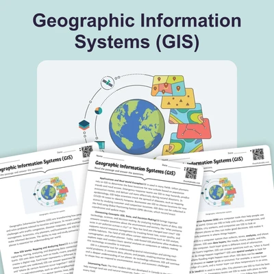
Remote Sensing: Gathering Earth’s Data from Afar
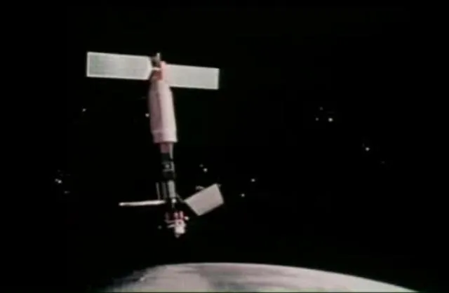
"Seasat Celebrates Landmark in Remote-Sensing History" / NASA (Public domain).
Remote sensing helps scientists observe and understand Earth’s surface and atmosphere without needing to be physically present. Every day, satellites, aircraft, and even balloons collect massive amounts of information about our planet. This process allows us to monitor land, water, and air, support disaster responses, and track environmental changes. By using remote sensing, scientists answer important questions about climate, resources, and human activities.
How Remote Sensing Works
Remote sensing uses special instruments on platforms like satellites, airplanes, drones, and balloons. These tools detect electromagnetic radiation—energy that travels in waves, including visible light, infrared, and radar. Each type of wave reveals unique information. For example, visible light lets us see forests and cities, while infrared identifies plant health and heat patterns. Instruments called sensors record data by capturing the amount and type of energy reflected or emitted from Earth’s surface. This information is turned into satellite imagery, which scientists analyze to detect changes over time.
Applications and Examples
Remote sensing has many important uses. Meteorologists use satellite images to monitor hurricanes and predict weather. Environmental scientists study land use changes, such as deforestation and urban growth, by comparing images from different years. The Landsat program has provided the longest continuous satellite imagery record since 1972, helping researchers track changes in forests, agriculture, and water bodies. In agriculture, multispectral imaging allows farmers to assess crop health by analyzing several wavelengths at once. Emergency responders use remote sensing to map flooded areas after storms, while military and national security agencies rely on these techniques for surveillance and reconnaissance.
Technologies, Accessibility, and Careers
Remote sensing uses the electromagnetic spectrum to collect data in different bands—like visible, infrared, and radar wavelengths. This allows for change detection, which means comparing images over time to spot differences, such as melting glaciers or new construction. Free tools like Google Earth, NASA WorldView, and Sentinel Hub make satellite imagery accessible to everyone, not just scientists. Careers in this field include geospatial analysts and remote sensing specialists, who use technology to solve environmental, agricultural, and security problems.
Remote sensing is a powerful example of how science and technology work together to help us understand our world. By observing Earth from afar, scientists can predict natural disasters, plan for climate change, and manage resources more wisely. As technology advances, remote sensing will become even more important for addressing global challenges.
Interesting Fact: The Landsat program has collected more than nine million images of Earth since 1972, making it the longest-running Earth observation mission in history.
Comprehension quiz (10 questions)
1. What is the main purpose of remote sensing?
2. Which of the following is NOT a platform used for remote sensing?
3. What type of electromagnetic wave is used to detect plant health in remote sensing?
4. What does 'change detection' mean in remote sensing?
5. Which program has the longest continuous record of satellite imagery?
6. What is the function of a sensor in remote sensing?
7. Which of these is a real-world use of remote sensing?
8. True or False: Multispectral imaging collects data using only one wavelength.
9. True or False: Remote sensing data is only available to scientists.
10. What career involves studying geographic data to solve environmental problems?
Perfect for the way you teach
- Build comprehension skills
- Auto-graded quiz
- Differentiated reading
- Read together at home
- Improve fluency
- Quiet reading time
- Reading curriculum support
- Independent practice
- Track Lexile growth