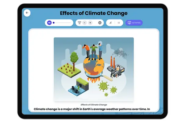
This Grade 6-8 science passage explores the important question: How do we measure global temperature change? Students learn about the science behind measuring Earth's temperature, including the use of thermometers, weather stations, satellites, and ocean buoys. The passage explains key terms such as 'average temperature,' 'climate,' and 'data,' helping students understand how scientists track temperature changes over time. Real-world examples, such as the use of satellites and how this data informs our understanding of climate change, are included. The passage aligns with NGSS standards and is designed for middle school readers, using accessible language and bolded glossary terms for easy reference. The resource features a Spanish translation, a glossary of important vocabulary, multiple-choice comprehension questions, and writing prompts encouraging critical thinking and connections to everyday life. Audio integration is available to support diverse learners. This resource is ideal for students and teachers exploring Earth science, climate, and scientific measurement.
Written by Workybooks TeamPublished by Workybooks
Preview
Sample passage and quiz content
CONTENT PREVIEW
Expand content preview
Taking Earth's temperature sounds simple, but it requires a complex system. Scientists don't use just one thermometer. They collect data from thousands of measurement stations across the planet. These stations include land-based weather stations, ocean buoys, and satellites orbiting above. Each location records temperature throughout the year. Together, these measurements create a picture of Earth's overall temperature.
Scientists face an important challenge when measuring global average temperature. Different regions naturally have different climates. Alaska stays cold while the Amazon stays warm. Simply averaging all temperatures wouldn't show meaningful change. Instead, scientists calculate something called a temperature anomaly. They compare each location's current temperature to its own long-term average, called a baseline. The baseline typically covers 30 years of data. If a location measures 2 degrees warmer than its baseline, the anomaly is positive 2 degrees.
Scientists then average all these anomalies from around the world. This method reveals whether the entire planet runs warmer or cooler than normal. A weather station in Chicago might record a cold January. But if thousands of other stations show warmer-than-normal readings, the global average can still increase. This explains why your backyard can feel cold during a warming trend. Local weather varies day to day, but climate describes long-term patterns across the whole planet.
Evidence shows this system works well. Multiple research groups analyze climate data independently. They use different methods and different station networks. Yet their results match closely. In 2020, NASA reported that Earth's average temperature had risen about 1.2 degrees Celsius since 1880. Other organizations found similar increases. This agreement strengthens confidence in the measurements.
Understanding global temperature matters for predicting future changes. Rising temperatures affect weather patterns, sea levels, and ecosystems worldwide. The global temperature record helps scientists identify trends and test climate models. These models guide decisions about reducing emissions and preparing for change. Accurate measurement provides the foundation for understanding our changing planet.
Interesting Fact: Ocean temperatures are harder to measure than land temperatures because oceans cover 71 percent of Earth's surface. Scientists use floating buoys, ships, and even tagged marine animals to collect water temperature data from remote areas.
What do scientists use to measure Earth's temperature?
One large thermometer at the North PoleThousands of measurement stations across land, ocean, and spaceOnly satellites orbiting EarthTemperature readings from major cities only
Why don't scientists simply average all temperatures from different locations?
Because different regions naturally have different climatesBecause thermometers are not accurate enoughBecause satellites cannot measure ocean temperaturesBecause weather stations are too far apart
What is a temperature anomaly?
The hottest temperature ever recordedThe difference between current temperature and long-term averageThe temperature measured by satellites onlyAn error in temperature measurement
How many years of data typically make up a baseline?
10 years20 years30 years50 years
According to the passage, what does climate describe?
Day-to-day changes in one locationOnly ocean temperaturesLong-term patterns across the whole planetTemperature in tropical regions only
Why can your backyard feel cold during a global warming trend?
Because global warming is not realBecause local weather varies while global average smooths over variationsBecause thermometers are brokenBecause satellites cannot measure local temperatures
How much has Earth's average temperature risen since 1880 according to NASA?
What strengthens confidence in global temperature measurements?
Only one research group studies the dataMultiple research groups using different methods get similar resultsSatellites measure temperature more accurately than weather stationsTemperature has not changed over time
True or False: Ocean temperatures are easier to measure than land temperatures.
TrueFalse
True or False: A cold January in Chicago means the global average temperature must be decreasing.
TrueFalse
Who it's for
Perfect for the way you teach
Teachers
Build comprehension skills
Auto-graded quiz
Differentiated reading
Parents
Read together at home
Improve fluency
Quiet reading time
Homeschoolers
Reading curriculum support
Independent practice
Track Lexile growth
Topics
global temperatureclimate changethermometersatellitedataaverage temperaturescience passageNGSSweatherearth
Reviews & Ratings
No reviews yet. Be the first to share your experience!