Reading PassagePremium

What Are Barrier Islands

Interactive passage with audio narration, comprehension questions, and printable PDF.

No ratings yet
Grades 5–8ScienceElaEnglish · SpanishInteractive · Printable
Aligned toMS-ESS2-2
Just this resource
$1.50
One-time purchase
Best value
Unlock everything
$49.99$29.99/yr
40% off until Aug 1 — 10,000+ resources
Renews at $49.99/year.
Unlock above to use these actions

What's included

Reading passage
Audio narration
Comprehension quiz
Writing activity
Glossary & flashcards
Differentiated version
Spanish translation

What Are Barrier Islands preview and details

About this printable What Are Barrier Islands science reading passage, NGSS-aligned (Grades 5-8)

This 450-word reading passage explores barrier islands as dynamic coastal landforms for middle school students in grades 6-8. Aligned with NGSS MS-ESS2-2 and MS-ESS2.A Earth's Materials and Systems, the lesson explains how barrier islands form through deposition of sand by waves, currents, and longshore drift. Students learn how these narrow ribbons of sand run parallel to coastlines, separated from the mainland by lagoons or bays. The passage examines how barrier islands protect mainland areas from storm waves while constantly changing shape and position through natural processes. Real-world examples include the Outer Banks of North Carolina, demonstrating the tension between human development and natural coastal dynamics. Audio-integrated content supports diverse learners with differentiated versions, Spanish translations, comprehension questions, writing activities, and graphic organizers that help students understand Earth's surface processes and human interactions with dynamic landscapes.
Written by Workybooks TeamPublished by Workybooks
Preview

Sample passage and quiz from What Are Barrier Islands

Reading passage and comprehension quiz preview

What Are Barrier Islands
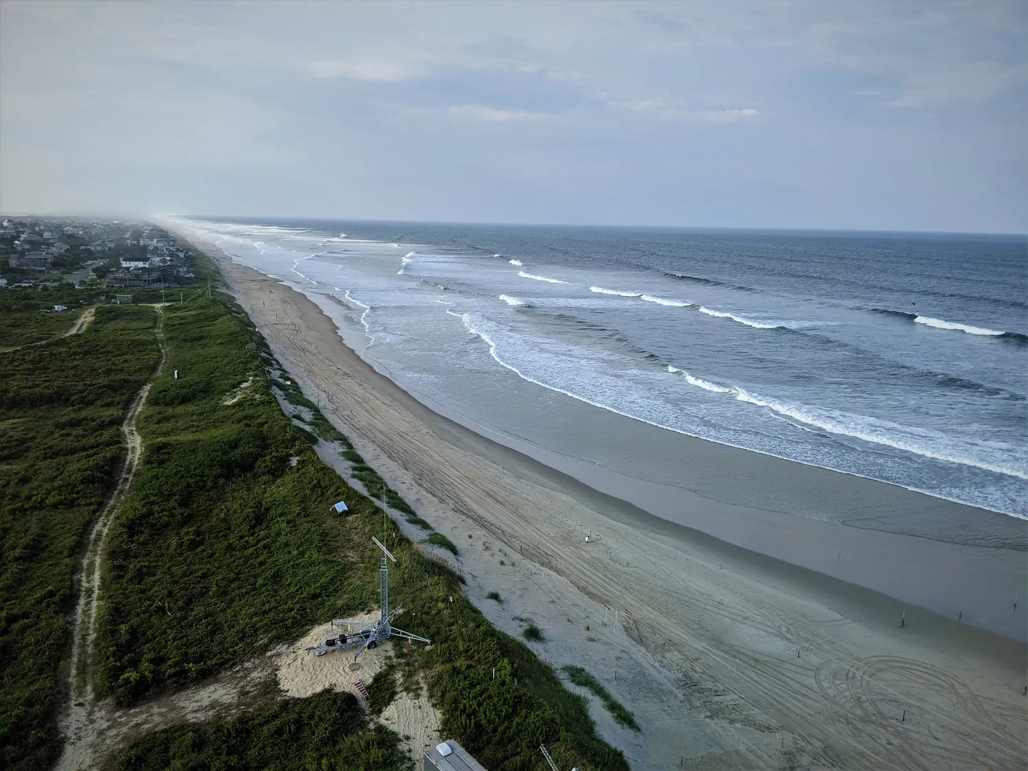
Outer Banks, North Carolina coastline (96594)

Outer Banks, North Carolina coastline by USGSCoastal and Marine Hazards and Resources Program / Wikimedia Commons 

A barrier island is a long, narrow ribbon of sand that lies just offshore from the mainland coast. These islands run parallel to the coastline and are separated from the mainland by a shallow lagoon or bay. Barrier islands form through the action of waves, ocean currents, and longshore drift, which move and pile sand into long strips. Scientists observe that these islands are among the most dynamic landforms on Earth, constantly changing shape and position.

Waves carry sand toward the shore through a process called deposition. Longshore drift moves this sand parallel to the coast, building up sediment in certain areas. Over time, these deposits can grow into long, narrow islands. The ocean side of a barrier island typically has a sandy beach and dunes, while the lagoon side has calmer, protected waters. Evidence shows that barrier islands can migrate landward over time, especially during powerful storms. Storm waves wash sand from the ocean side over to the lagoon side, causing the entire island to shift position.

True to their name, barrier islands act as natural barriers for the mainland behind them. They absorb the force of storm waves and reduce erosion of the coast. The shallow lagoons between barrier islands and the mainland provide important habitats for fish, birds, and other wildlife. However, barrier islands themselves can change dramatically during hurricanes and nor'easters. A single major storm can reshape an island's outline, create new inlets, or wash away entire sections of beach.

The Outer Banks of North Carolina provides a clear example of barrier islands in action. This chain of narrow islands stretches for over 100 miles along the coast. Scientists have documented how these islands migrate westward over time, moving closer to the mainland. Many barrier islands, including parts of the Outer Banks, have beach towns and resorts built on them. This creates a challenge because people want stable land for homes and businesses, but the islands naturally shift and change. Coastal development on barrier islands can interfere with natural sand movement and increase property damage during storms.

Understanding barrier islands matters because millions of people live on or visit these landforms each year. Scientists explain that barrier islands demonstrate how Earth's surface is constantly shaped by natural processes. Recognizing that these islands migrate helps communities make better decisions about where to build and how to protect both people and natural coastal systems. Barrier islands remind us that some landforms are temporary features that change with the forces acting upon them.

Interesting Fact: Some barrier islands can migrate landward at rates of several feet per year. During Hurricane Sandy in 2012, parts of barrier islands along the New Jersey coast moved more than 100 feet in just a few days.

Comprehension quiz (10 questions)

1. What is a barrier island?

A mountain range near the ocean
A long, narrow ribbon of sand lying offshore, parallel to the coast
A deep underwater canyon
A type of coral reef

2. What separates barrier islands from the mainland?

A deep ocean trench
A mountain range
A shallow lagoon or bay
A river delta

3. Which process moves sand parallel to the coast to help build barrier islands?

Volcanic eruption
Earthquake activity
Longshore drift
Glacier movement

4. In the passage, the word 'deposition' refers to:

The removal of sand from a beach
The addition of sediment to a landform
The melting of ice into water
The formation of clouds

5. How do barrier islands protect the mainland?

By creating strong winds
By absorbing the force of storm waves and reducing erosion
By causing more hurricanes
By making the water deeper

6. Why do barrier islands migrate landward over time?

Because people move them with machines
Because storm waves wash sand from the ocean side to the lagoon side
Because they sink into the ocean
Because fish push them toward shore

7. What challenge does coastal development on barrier islands create?

It makes the islands grow larger
It stops all hurricanes
People want stable land, but the islands naturally shift and change
It creates more sand on the beaches

8. Based on the passage, which statement best describes barrier islands?

They are permanent landforms that never change
They are among the most dynamic landforms on Earth
They only exist in one location
They are made of solid rock

9. True or False: The Outer Banks of North Carolina is an example of a chain of barrier islands.

True
False

10. True or False: Barrier islands always stay in the same position and never move.

True
False
Who it's for

Perfect for the way you teach

Teachers
  • Build comprehension skills
  • Auto-graded quiz
  • Differentiated reading
Parents
  • Read together at home
  • Improve fluency
  • Quiet reading time
Homeschoolers
  • Reading curriculum support
  • Independent practice
  • Track Lexile growth
Topics

Reviews & Ratings

No reviews yet. Be the first to share your experience!

More reading you might love

20 more
Passage
Talus Slopes: Formation and Features - reading educational content
Grades 5–8

Talus Slopes: Formation and Features

science · MS-ESS2-1

Free
Passage
Stratigraphic Columns: Decoding Earth’s Geological Layers - reading educational content
Grades 5–8

Stratigraphic Columns: Decoding Earth’s Geological Layers

science · MS-ESS2-2

Free
Passage
Frost Wedging: How Ice Splits Rock - reading educational content
Grades 5–8

Frost Wedging: How Ice Splits Rock

science · MS-ESS2-1

$1.50
Passage
Chemical Weathering: The Breakdown of Rocks Through Chemical Reactions - reading educational content
Grades 5–8

Chemical Weathering: The Breakdown of Rocks Through Chemical Reactions

science · MS-ESS2-1

Free
Passage
What Is Space Weather and How Does It Affect the Earth? - reading educational content
Grades 3–7

What Is Space Weather and How Does It Affect the Earth?

science · MS-ESS2-2

$1.50
Passage
When Was The Last Ice Age - reading educational content
Grade 6

When Was The Last Ice Age

earth science · MS-ESS2-2

$1.50
Passage
Tools and Technology in Earth Science - reading educational content
Grades 5–8

Tools and Technology in Earth Science

science · MS-ESS2-2

$1.50
Passage
Maps and Mapping - reading educational content
Grades 5–8

Maps and Mapping

earth science · MS-ESS2-2

$1.50
Passage
Latitude and Longitude - reading educational content
Grades 5–8

Latitude and Longitude

earth science · MS-ESS2-2

$1.50
Passage
Topographic Maps - reading educational content
Grades 5–8

Topographic Maps

earth science · MS-ESS2-2

$1.50
Passage
Contour Lines and Elevation - reading educational content
Grades 5–8

Contour Lines and Elevation

science · MS-ESS2-2

$1.50
Passage
Types of Maps  - reading educational content
Grades 5–8

Types of Maps

earth science · MS-ESS2-2

$1.50
Passage
Mountains and Mountain Building - reading educational content
Grades 5–8

Mountains and Mountain Building

science · MS-ESS2-1

$1.50
Passage
Earth's Interior - reading educational content
Grades 5–8

Earth's Interior

science · MS-ESS2-1

$1.50
Passage
Continental Drift Theory - reading educational content
Grades 5–8

Continental Drift Theory

science · MS-ESS2-2

Free
Passage
Seafloor Spreading - reading educational content
Grades 5–8

Seafloor Spreading

science · MS-ESS2-2

$1.50
Passage
Theory of Plate Tectonics - reading educational content
Grades 5–8

Theory of Plate Tectonics

science · MS-ESS2-2

$1.50
Passage
Divergent Plate Boundaries - reading educational content
Grades 5–8

Divergent Plate Boundaries

science · MS-ESS2-2

$1.50
Passage
Convergent Plate Boundaries - reading educational content
Grades 5–8

Convergent Plate Boundaries

science · MS-ESS2-2

$1.50
Passage
Transform Plate Boundaries - reading educational content
Grades 5–8

Transform Plate Boundaries

science · MS-ESS2-2

$1.50
Copyright © 2026 Workybooks. Made with ♥ in California.