Reading PassagePremium

How Did the Andes Form

Interactive passage with audio narration, comprehension questions, and printable PDF.

No ratings yet
Grades 5–8ScienceElaEnglish · SpanishInteractive · Printable
Aligned toMS-ESS2-2
Just this resource
$1.50
One-time purchase
Best value
Unlock everything
$49.99$24.99/yr
50% off until Sept 15 — 10,000+ resources
Renews at $49.99/year.

By completing this purchase you agree to our Terms of Use and Privacy Policy. Your subscription renews automatically until you cancel. You can cancel anytime from your account settings. All sales are final and non-refundable. Digital content is available for download in your account immediately upon purchase.

Unlock above to use these actions

What's included

Reading passage
Audio narration
Comprehension quiz
Writing activity
Glossary & flashcards
Differentiated version
Spanish translation

How Did the Andes Form preview and details

About this printable How Did the Andes Form science reading passage, NGSS-aligned (Grades 5-8)

This comprehensive middle school science passage explores how the Andes Mountains formed through the process of subduction, aligning with NGSS standard MS-ESS2-2. Students learn how the oceanic Nazca Plate dives beneath the continental South American Plate, creating the world's longest mountain range. The passage contrasts this subduction-driven mountain building with the collision process that formed the Himalayas. Through clear explanations and real-world examples, students discover why the Andes contain both folded mountains and active volcanoes. The audio-integrated lesson includes key vocabulary terms such as subduction zone, convergent boundary, magma, and tectonic plates. Activities engage students in analyzing the relationship between plate boundary types and mountain formation, helping them understand Earth's dynamic surface processes. This resource supports the Disciplinary Core Idea MS-ESS2.B: Plate Tectonics and Large-Scale System Interactions, providing students with evidence-based explanations of how Earth's major features form through plate interactions.
Written by Workybooks TeamPublished by Workybooks
Preview

Sample passage and quiz from How Did the Andes Form

Reading passage and comprehension quiz preview

How Did the Andes Form
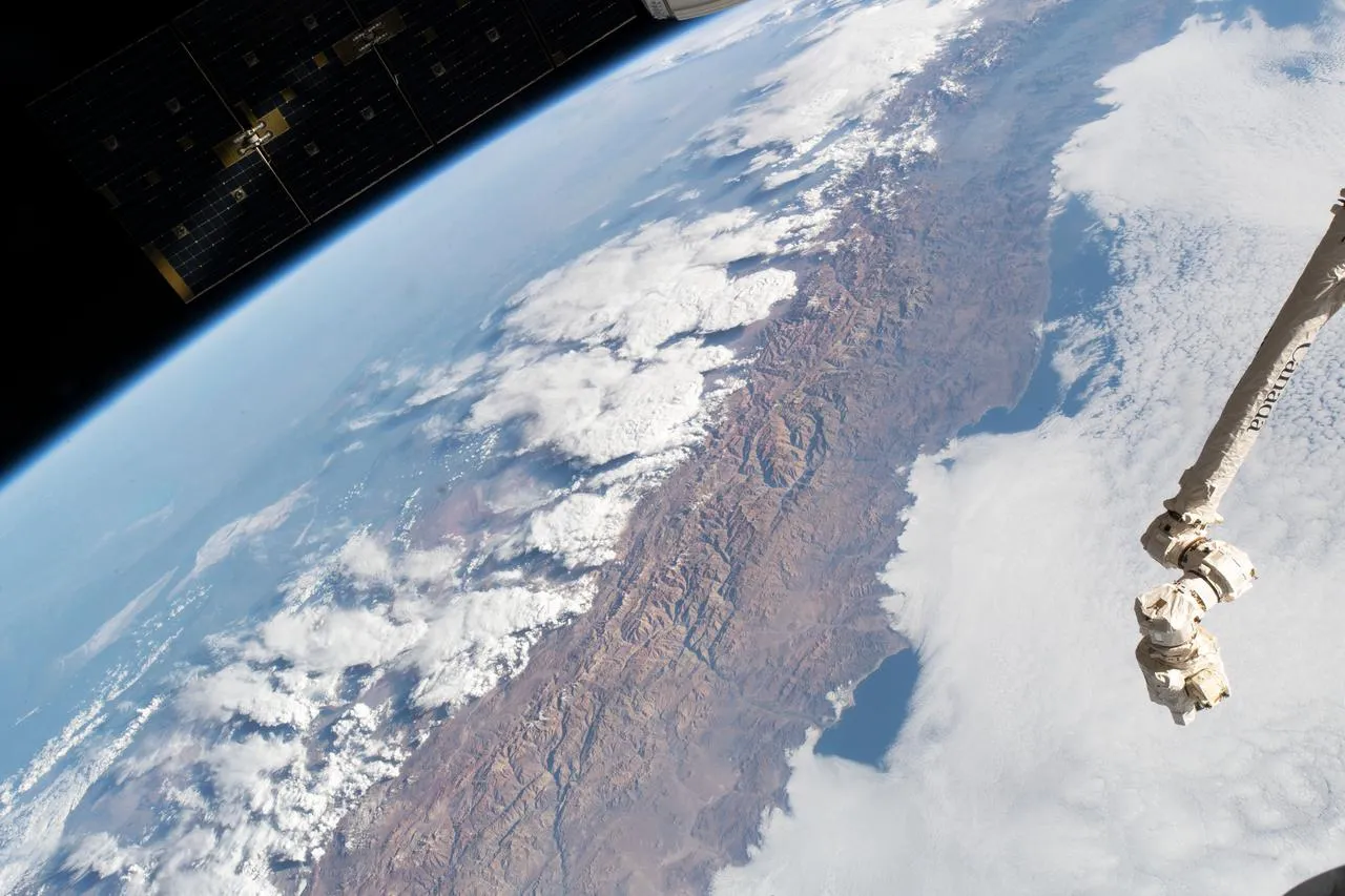
The Andes Mountain range

"The Andes Mountain range" / NASA.

The Andes Mountains formed through a process called subduction. This mountain range stretches along South America's western coast for over 4,000 miles. The Andes are the world's longest continental mountain range. Scientists explain that these mountains formed differently than the Himalayas.

Off South America's western coast, two tectonic plates meet at a convergent boundary. The oceanic Nazca Plate dives beneath the continental South American Plate. This creates a subduction zone. Evidence shows that subduction does two important things at once. First, it pushes and folds the edge of the continent upward. This creates tall, folded mountains. Second, the subducting plate sinks deep into Earth's hot interior.

As the Nazca Plate descends, intense heat and pressure cause it to melt. This melting produces hot, liquid rock called magma. The magma is less dense than surrounding rock, so it rises upward. When magma reaches the surface, it erupts as lava from volcanoes. That is why the Andes contain many active volcanoes mixed with folded mountains. Scientists observe that this volcanic activity continues today.

The Andes differ from the Himalayas in a key way. The Himalayas formed when two continental plates collided with no subduction involved. The Andes formed where an oceanic plate subducts beneath a continental plate. This difference in plate boundary type creates different mountain characteristics. Subduction zones produce both folded mountains and volcanic chains. Continental collision zones produce only folded mountains without volcanic activity.

Understanding how the Andes formed helps scientists predict where earthquakes and volcanic eruptions may occur. The type of plate boundary determines what kind of mountains rise. This knowledge matters for millions of people living near active plate boundaries around the world.

Interesting Fact: The Andes contain more than 50 active volcanoes, making it one of the most volcanically active mountain ranges on Earth.

Comprehension quiz (10 questions)

1. What process formed the Andes Mountains?

Subduction
Erosion
Volcanic eruption only
Continental drift

2. Which two plates meet to form the Andes Mountains?

Pacific Plate and North American Plate
Nazca Plate and South American Plate
African Plate and Eurasian Plate
Indian Plate and Asian Plate

3. What does the term 'subduction zone' mean in the passage?

A place where plates slide past each other
A region where one plate dives beneath another plate
An area where new crust forms
A location where plates move apart

4. What happens to the Nazca Plate as it descends into Earth's interior?

It cools and becomes harder
It breaks into smaller pieces
It melts due to heat and pressure
It stops moving completely

5. Why does magma rise upward after the plate melts?

Because it is pushed by earthquakes
Because it is less dense than surrounding rock
Because it is pulled by gravity
Because it is cooler than other rocks

6. How are the Andes different from the Himalayas?

The Andes are shorter than the Himalayas
The Andes formed from subduction while the Himalayas formed from continental collision
The Andes have no volcanoes while the Himalayas have many
The Andes are older than the Himalayas

7. What can scientists predict by understanding how the Andes formed?

Weather patterns in South America
Ocean currents along the coast
Where earthquakes and volcanic eruptions may occur
The age of rocks in the mountains

8. According to the passage, what creates the volcanoes in the Andes?

Erosion of mountain peaks
Collision of two continental plates
Rising magma that erupts at the surface
Movement of glaciers

9. True or False: The Andes Mountains contain both folded mountains and active volcanoes.

True
False

10. True or False: Continental collision zones produce both folded mountains and volcanic activity.

True
False
Who it's for

Perfect for the way you teach

Teachers
  • Build comprehension skills
  • Auto-graded quiz
  • Differentiated reading
Parents
  • Read together at home
  • Improve fluency
  • Quiet reading time
Homeschoolers
  • Reading curriculum support
  • Independent practice
  • Track Lexile growth
Topics

Reviews & Ratings

No reviews yet. Be the first to share your experience!

More reading you might love

20 more
Passage
Talus Slopes: Formation and Features - reading educational content
Grades 5–8

Talus Slopes: Formation and Features

science · MS-ESS2-1+2

Free
Passage
Stratigraphic Columns: Decoding Earth’s Geological Layers - reading educational content
Grades 5–8

Stratigraphic Columns: Decoding Earth’s Geological Layers

science · MS-ESS2-2+2

Free
Passage
Frost Wedging: How Ice Splits Rock - reading educational content
Grades 5–8

Frost Wedging: How Ice Splits Rock

earth and space science · MS-ESS2-1+2

$1.50
Passage
Chemical Weathering: The Breakdown of Rocks Through Chemical Reactions - reading educational content
Grades 5–8

Chemical Weathering: The Breakdown of Rocks Through Chemical Reactions

earth and space science · MS-ESS2-1+2

Free
Passage
What Is Space Weather and How Does It Affect the Earth? - reading educational content
Grades 3–7

What Is Space Weather and How Does It Affect the Earth?

earth and space science · MS-ESS2-2

$1.50
Passage
When Was The Last Ice Age - reading educational content
Grade 6

When Was The Last Ice Age

earth and space science · MS-ESS2-2

$1.50
Passage
Tools and Technology in Earth Science - reading educational content
Grades 5–8

Tools and Technology in Earth Science

science · MS-ESS2-2+4

$1.50
Passage
Maps and Mapping - reading educational content
Grades 5–8

Maps and Mapping

earth and space science · MS-ESS2-2

$1.50
Passage
Latitude and Longitude - reading educational content
Grades 5–8

Latitude and Longitude

earth and space science · MS-ESS2-2

$1.50
Passage
Topographic Maps - reading educational content
Grades 5–8

Topographic Maps

earth and space science · MS-ESS2-2+3

$1.50
Passage
Contour Lines and Elevation - reading educational content
Grades 5–8

Contour Lines and Elevation

earth and space science · MS-ESS2-2+3

$1.50
Passage
Maps and Their Uses - reading educational content
Grades 5–8

Maps and Their Uses

earth and space science · MS-ESS2-2+5

$1.50
Passage
Mountains and Mountain Building - reading educational content
Grades 5–8

Mountains and Mountain Building

earth and space science · MS-ESS2-1+1

$1.50
Passage
Earth's Interior - reading educational content
Grades 5–8

Earth's Interior

earth and space science · MS-ESS2-1+1

$1.50
Passage
Continental Drift Theory - reading educational content
Grades 5–8

Continental Drift Theory

earth and space science · MS-ESS2-2+1

Free
Passage
Seafloor Spreading - reading educational content
Grades 5–8

Seafloor Spreading

science · MS-ESS2-2+1

$1.50
Passage
Theory of Plate Tectonics - reading educational content
Grades 5–8

Theory of Plate Tectonics

earth and space science · MS-ESS2-2

$1.50
Passage
Divergent Plate Boundaries - reading educational content
Grades 5–8

Divergent Plate Boundaries

earth and space science · MS-ESS2-2

$1.50
Passage
Convergent Plate Boundaries - reading educational content
Grades 5–8

Convergent Plate Boundaries

earth and space science · MS-ESS2-2

$1.50
Passage
Transform Plate Boundaries - reading educational content
Grades 5–8

Transform Plate Boundaries

earth and space science · MS-ESS2-2

$1.50
Copyright © 2026 Workybooks Classroom. Made with ♥ in California.