How Do Geologists Locate Resources
Interactive passage with audio narration, comprehension questions, and printable PDF.
By completing this purchase you agree to our Terms of Use and Privacy Policy. Your subscription renews automatically until you cancel. You can cancel anytime from your account settings. All sales are final and non-refundable. Digital content is available for download in your account immediately upon purchase.
What's included
How Do Geologists Locate Resources preview and details
About this printable How Do Geologists Locate Resources science reading passage, NGSS-aligned (Grades 6-8)
Sample passage and quiz from How Do Geologists Locate Resources
Reading passage and comprehension quiz preview
How Scientists Locate Resources
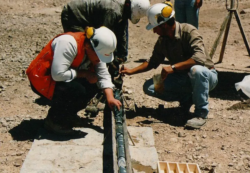
Geologists collect rock samples from surface outcrops, dig trenches, or drill cores that bring up cylindrical samples from deep underground.. Exploration geologist by Geoz assumed (based on copyright claims). / Wikimedia Commons
Geologists are scientists who study Earth's structure and the materials that make up our planet. One of their most important jobs is locating valuable mineral deposits and energy resources like oil, natural gas, and coal buried beneath the surface. Finding these resources is not a matter of luck. Scientists use specific methods based on their understanding of how geological processes concentrate resources in certain locations.
The first major exploration method is seismic surveys, which use sound waves to create images of underground rock layers. Scientists generate vibrations at the surface using special equipment, and these vibrations travel down through different rock layers. When the sound waves encounter boundaries between different types of rock, some of the energy bounces back to the surface where instruments called geophones detect them. By analyzing the timing and strength of these returning waves, geologists can map the structure of rocks thousands of feet below the surface. This method is particularly useful for finding oil and natural gas, which often accumulate in curved rock layers called anticlines that trap these fluids.
A second method is remote sensing, which involves collecting information about Earth's surface from a distance, usually from satellites or aircraft. Remote sensing instruments detect different types of energy reflected or emitted from rocks and soil. Different minerals reflect light in characteristic ways, creating unique patterns that scientists can identify. For example, areas with iron-rich minerals might appear reddish in satellite images, while areas with copper deposits might show specific color signatures. Remote sensing helps geologists identify large areas that deserve closer investigation without having to visit every location physically.
Direct rock sampling provides the most concrete evidence of what lies beneath the surface. Geologists collect rock samples from surface outcrops, dig trenches, or drill cores that bring up cylindrical samples from deep underground. These samples reveal the exact mineral content, age, and formation conditions of rocks. By studying how minerals are distributed in samples from different locations, scientists can trace patterns that lead to larger deposits. For instance, small amounts of gold in stream sediments might indicate a major gold deposit upstream where the sediment originated.
Geochemical analysis examines the chemical composition of rocks, soil, water, and even plants to detect traces of valuable elements. Scientists collect samples and use laboratory instruments to measure concentrations of specific elements. Certain elements tend to occur together in nature, so finding elevated levels of one element might indicate the presence of another valuable resource nearby. Water samples from wells can reveal dissolved minerals that traveled through underground rock formations, providing clues about deposits that cannot be seen directly.
These exploration methods work because geological processes concentrate resources in predictable settings. Plate tectonics creates mountain ranges where erosion exposes mineral veins. Volcanic activity brings metals from deep within Earth to the surface. Ancient seas deposited layers of organic material that transformed into oil and coal over millions of years. Understanding these processes helps geologists predict where resources are likely to be found. They look for geological formations with characteristics known to host specific resources, making exploration more efficient and successful.
Interesting Fact: The world's deepest drill hole, the Kola Superdeep Borehole in Russia, reached 7.5 miles into Earth's crust and took 20 years to complete, yet it only penetrated about one-third of the way through the continental crust.
Comprehension quiz (10 questions)
1. What do seismic surveys use to create images of underground rock layers?
2. Which exploration method involves collecting information from satellites or aircraft?
3. What is the term for curved rock layers that trap oil and natural gas?
4. In the context of this passage, what does 'geochemical analysis' mean?
5. What does the term 'geological formations' refer to?
6. Why do exploration methods work for finding resources in predictable locations?
7. How does finding small amounts of gold in stream sediments help geologists?
8. Which geological process brings metals from deep within Earth to the surface?
9. True or False: Geophones are instruments that detect sound waves returning from underground.
10. True or False: Remote sensing requires scientists to physically visit every location they want to study.
Perfect for the way you teach
- Build comprehension skills
- Auto-graded quiz
- Differentiated reading
- Read together at home
- Improve fluency
- Quiet reading time
- Reading curriculum support
- Independent practice
- Track Lexile growth