How Scientists Design Environmental Monitoring Systems
Interactive passage with audio narration, comprehension questions, and printable PDF.
What's included
How Scientists Design Environmental Monitoring Systems preview and details
About this printable How Scientists Design Environmental Monitoring Systems science reading passage, NGSS-aligned (Grades 6-8)
Sample passage and quiz from How Scientists Design Environmental Monitoring Systems
Reading passage and comprehension quiz preview
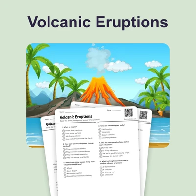
How Scientists Monitor Earth's Systems
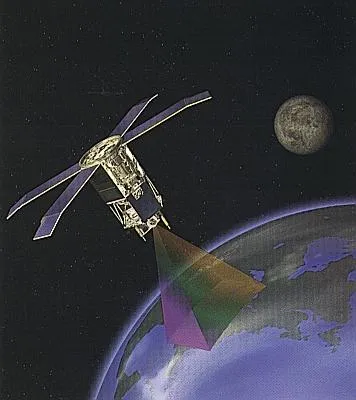
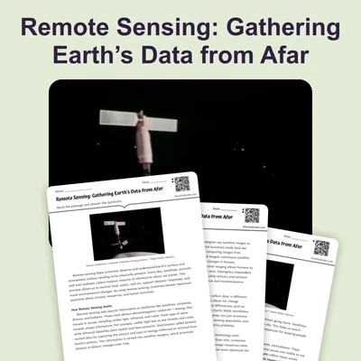
"SeaStar satellite orbit" by NASA / Wikimedia Commons.
Scientists need accurate information about Earth's systems to understand how our planet is changing. Monitoring means collecting data over time to track changes in the environment. Scientists use four main tools to monitor Earth's land, water, atmosphere, and living things: satellites, sensors, field surveys, and data models. Each tool provides different types of information that work together to create a complete picture of Earth's health.
Satellites orbit Earth and use remote sensing technology to observe large areas from space. These spacecraft carry instruments that measure temperature, track storms, photograph forests, and monitor ocean conditions. For example, satellites can detect when forests are being cut down by comparing images taken months or years apart. They can also measure sea surface temperatures to track coral reef health. Satellites provide a bird's-eye view that would be impossible to achieve from the ground, allowing scientists to monitor changes across entire continents and oceans.
Ground-based sensors collect detailed information at specific locations. These instruments measure air quality, water chemistry, soil moisture, and weather conditions continuously. A network of sensors in a city might track pollution levels every hour, creating a detailed record of air quality changes. Weather stations use sensors to measure temperature, humidity, wind speed, and rainfall. Ocean buoys equipped with sensors monitor water temperature, salinity, and wave height. Unlike satellites that observe from above, sensors provide precise measurements at ground level.
Field surveys involve scientists directly observing and collecting samples in natural environments. Researchers might count bird populations in a forest, measure glacier thickness in Antarctica, or collect water samples from rivers to test for pollutants. Field surveys provide information that satellites and sensors cannot capture, such as the health of individual plants or the behavior of animals. These surveys also help scientists verify and calibrate the data collected by satellites and sensors.
Scientists combine all this monitoring data using data models, which are computer programs that analyze patterns and make predictions. Models can identify trends, which are patterns of change over time. For instance, if air quality sensors show pollution levels decreasing over five years, that downward pattern is a trend. Models can also predict future conditions based on current data. When monitoring reveals concerning trends like rising ocean temperatures or declining bee populations, this evidence can trigger policy responses—actions taken by governments or organizations to address environmental problems.
Monitoring data also measures whether environmental interventions are working. If a city installs pollution controls on factories, sensors can track whether air quality actually improves. If a country protects a forest from logging, satellites can verify that the forest remains intact. This feedback loop allows scientists and policymakers to evaluate their efforts and make adjustments when needed. Without monitoring, we would not know if conservation actions are succeeding or failing.
The combination of satellites, sensors, field surveys, and data models creates a comprehensive Earth monitoring system. Each method has strengths that complement the others. Satellites provide broad coverage, sensors offer precise local measurements, field surveys add ground-truth observations, and models help interpret all this information. Together, these tools help scientists understand Earth's complex systems and guide decisions that protect our planet's future.
Interesting Fact: NASA's Landsat satellites have been continuously photographing Earth since 1972, creating a 50-year visual record of environmental changes including urban growth, glacier retreat, and deforestation across the entire planet.
Comprehension quiz (10 questions)
1. What does monitoring mean in the context of Earth science?
2. How do satellites detect deforestation?
3. What is the main advantage of ground-based sensors compared to satellites?
4. What does the term 'remote sensing' refer to?
5. Which monitoring tool would be BEST for counting bird populations in a specific forest?
6. What is a trend in environmental monitoring?
7. How do data models help scientists understand monitoring information?
8. According to the passage, monitoring data can trigger policy responses when it reveals concerning trends.
9. Satellites can measure the health of individual plants and animals.
10. Why is it important to measure whether environmental interventions are working?
Perfect for the way you teach
- Build comprehension skills
- Auto-graded quiz
- Differentiated reading
- Read together at home
- Improve fluency
- Quiet reading time
- Reading curriculum support
- Independent practice
- Track Lexile growth