Reading PassagePremium

How Seismic Maps Help Communities

Interactive passage with audio narration, comprehension questions, and printable PDF.

No ratings yet
Grades 5–8ScienceElaEnglish · SpanishInteractive · Printable
Aligned toMS-ESS3-2
Just this resource
$1.50
One-time purchase
Best value
Unlock everything
$49.99$29.99/yr
40% off until Aug 1 — 10,000+ resources
Renews at $49.99/year.
Unlock above to use these actions

What's included

Reading passage
Audio narration
Comprehension quiz
Writing activity
Glossary & flashcards
Differentiated version
Spanish translation

How Seismic Maps Help Communities preview and details

About this printable How Seismic Maps Help Communities science reading passage, NGSS-aligned (Grades 5-8)

This 400-500 word informational science reading passage explores how seismic hazard maps help communities prepare for earthquakes. Aligned with NGSS standards MS-ESS3-2 and DCI MS-ESS3.B, the passage explains how scientists create these maps by combining data on fault locations, earthquake history, and ground composition. Students learn why loose soil shakes more violently than bedrock and how communities apply this scientific data to write building codes, plan emergency services, set insurance rates, and make informed decisions about construction zones. The lesson emphasizes the real-world connection between earthquake science and community safety, demonstrating how interpreting hazard data reduces damage before earthquakes strike. Audio-integrated features support diverse learners, while differentiated versions and Spanish translations ensure accessibility for all middle school students studying natural hazards and Earth systems.
Written by Workybooks TeamPublished by Workybooks
Preview

Sample passage and quiz from How Seismic Maps Help Communities

Reading passage and comprehension quiz preview

How Seismic Maps Help Communities
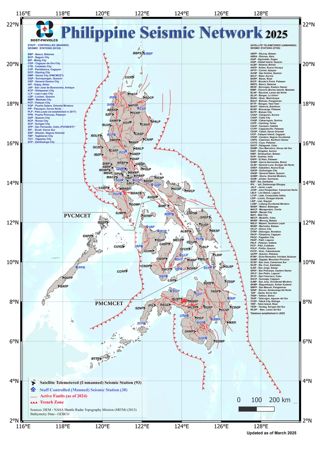
Philippine Seismic Network March 2025 updated

"Philippine Seismic Network March 2025 updated" by Philippine Institute of Volcanology and Seismology / Wikimedia Commons (Public domain).

When an earthquake strikes, some neighborhoods experience severe damage while others remain mostly safe. Scientists create seismic hazard maps to show which areas face the greatest earthquake risk. These maps help communities prepare and protect lives before the ground starts shaking.

Scientists build seismic hazard maps by combining three types of data. First, they locate known faults, which are cracks in Earth's crust where earthquakes occur. Second, they study the history of past earthquakes in the region. Evidence shows that areas with frequent past quakes may experience future ones. Third, scientists examine the type of ground beneath buildings. Bedrock, which is solid rock, shakes less during earthquakes. Loose, soft soil shakes far more violently and can even turn liquid-like during strong shaking, a process called liquefaction.

Communities use seismic hazard maps in powerful ways to reduce earthquake damage. City planners write stricter building codes for high-risk zones, requiring stronger construction methods. Hospitals and fire stations are built on safer ground when possible. Insurance companies set rates based on earthquake risk levels shown on the maps. Before approving new construction, officials check seismic maps to avoid the most dangerous areas.

In California, seismic hazard maps have guided decisions for decades. The San Francisco Bay Area sits near the San Andreas Fault, one of the most active fault systems in North America. Scientists observe ongoing ground movement and update hazard maps regularly. After studying these maps, the city strengthened thousands of older buildings and created emergency response plans. This preparation can reduce injuries and save lives when earthquakes strike.

Seismic hazard maps matter because they connect earthquake science to real decisions. By interpreting hazard data, communities can strengthen weak buildings, plan evacuation routes, and educate residents about safety. Scientists explain that while we cannot prevent earthquakes, understanding where and how strongly the ground may shake helps communities prepare effectively.

Interesting Fact: Japan uses advanced seismic hazard maps combined with early warning systems that can alert people up to 30 seconds before strong shaking arrives, giving them time to take cover.

Comprehension quiz (10 questions)

1. What three types of data do scientists combine to create seismic hazard maps?

Weather patterns, ocean currents, and temperature readings
Fault locations, earthquake history, and ground type
Building heights, population density, and road systems
Volcanic activity, tsunamis, and landslides

2. According to the passage, why does soft soil shake more violently than bedrock during earthquakes?

Soft soil is closer to fault lines than bedrock
Bedrock is solid rock that shakes less, while loose soil shakes far more violently
Soft soil contains more water than bedrock
Bedrock absorbs all earthquake energy

3. What does the term 'liquefaction' mean in the context of earthquakes?

When water floods an area after an earthquake
When buildings collapse into rubble
When loose, soft soil turns liquid-like during strong shaking
When lava flows from volcanic activity

4. How do communities use seismic hazard maps to protect people?

They predict exactly when earthquakes will occur
They write stricter building codes, plan emergency services, and decide where to build
They prevent all earthquakes from happening
They evacuate entire cities permanently

5. What real-world example does the passage provide about seismic map use?

New York City building subway tunnels
Tokyo creating tsunami walls
San Francisco strengthening buildings near the San Andreas Fault
Seattle constructing a new airport

6. Based on the passage, what can scientists do about earthquakes?

Prevent them from occurring
Stop them once they start
Understand where and how strongly the ground may shake to help communities prepare
Make them happen in safer locations

7. Why would insurance companies charge different rates based on seismic hazard maps?

Areas with higher earthquake risk have greater potential for damage and claims
Insurance companies want to make more money from everyone
All areas have the same earthquake risk
Insurance rates are not related to earthquake danger

8. What does the passage suggest about the relationship between past earthquakes and future risk?

Past earthquakes have no connection to future ones
Areas with frequent past earthquakes may experience future ones
Past earthquakes prevent future earthquakes in the same location
Only areas without past earthquakes are at risk

9. True or False: Seismic hazard maps are updated regularly as scientists observe ongoing ground movement.

True
False

10. True or False: According to the passage, we can prevent earthquakes by studying seismic hazard maps.

True
False
Who it's for

Perfect for the way you teach

Teachers
  • Build comprehension skills
  • Auto-graded quiz
  • Differentiated reading
Parents
  • Read together at home
  • Improve fluency
  • Quiet reading time
Homeschoolers
  • Reading curriculum support
  • Independent practice
  • Track Lexile growth
Topics

Reviews & Ratings

No reviews yet. Be the first to share your experience!

More reading you might love

20 more
Passage
Natural Disaster: Earthquake - reading educational content
Grades 4–5

Natural Disaster: Earthquake

weather and climate · RI.3.1

Free
Passage
Obsidian: The Natural Glass Rock - reading educational content
Grades 5–8

Obsidian: The Natural Glass Rock

earth and space science · MS-ESS2-3

Free
Passage
All About Seismometers - reading educational content
Grades 5–8

All About Seismometers

earth and space science · MS-ESS3-2

Free
Passage
What Is the Difference Between Magma and Lava? - reading educational content
Grades 5–8

What Is the Difference Between Magma and Lava?

earth and space science · MS-ESS2-3

$1.50
Passage
Tools and Technology in Earth Science - reading educational content
Grades 5–8

Tools and Technology in Earth Science

science · MS-ESS2-2

$1.50
Passage
Maps and Their Uses - reading educational content
Grades 5–8

Maps and Their Uses

earth and space science · MS-ESS2-2

$1.50
Passage
Mass Movements - reading educational content
Grades 5–8

Mass Movements

science · MS-ESS2-1

$1.50
Passage
What Causes Earthquakes? - reading educational content
Grades 5–8

What Causes Earthquakes?

earth and space science · MS-ESS2-2

$1.50
Passage
Floods: Causes and Types - reading educational content
Grades 5–8

Floods: Causes and Types

weather and climate · MS-ESS3-2

$1.50
Passage
Hurricanes and Tropical Cyclones - reading educational content
Grades 5–8

Hurricanes and Tropical Cyclones

weather and climate · MS-ESS3-2

$1.50
Passage
Hurricane Preparedness and Safety - reading educational content
Grades 5–8

Hurricane Preparedness and Safety

weather and climate · MS-ESS3-2

$1.50
Passage
Tornadoes - reading educational content
Grades 5–8

Tornadoes

weather and climate · MS-ESS3-2

$1.50
Passage
Tsunamis - reading educational content
Grades 5–8

Tsunamis

earth and space science · MS-ESS3-2

$1.50
Passage
Tsunami Warning and Safety - reading educational content
Grades 5–8

Tsunami Warning and Safety

weather and climate · MS-ESS3-2

$1.50
Passage
Earthquake Hazards and Damage - reading educational content
Grades 5–8

Earthquake Hazards and Damage

earth and space science · MS-ESS3-2

$1.50
Passage
Earthquake Zones and Patterns - reading educational content
Grades 5–8

Earthquake Zones and Patterns

earth and space science · MS-ESS2-2

$1.50
Passage
Seismic Waves - reading educational content
Grades 5–8

Seismic Waves

earth and space science · MS-ESS2-2

$1.50
Passage
Measuring Earthquakes - reading educational content
Grades 5–8

Measuring Earthquakes

earth and space science · MS-ESS2-2

$1.50
Passage
Earthquake Safety and Preparedness - reading educational content
Grades 5–8

Earthquake Safety and Preparedness

earth and space science · MS-ESS3-2

$1.50
Passage
Volcanic Eruptions and Products - reading educational content
Grades 5–8

Volcanic Eruptions and Products

earth and space science · MS-ESS2-2

$1.50
Copyright © 2026 Workybooks. Made with ♥ in California.