Reading PassagePremium

What Are Earth's Major Plates

Interactive passage with audio narration, comprehension questions, and printable PDF.

No ratings yet
Grades 5–8ScienceElaEnglish · SpanishInteractive · Printable
Aligned toMS-ESS2-2
Just this resource
$1.50
One-time purchase
Best value
Unlock everything
$49.99$24.99/yr
50% off until Sept 15 — 10,000+ resources
Renews at $49.99/year.

By completing this purchase you agree to our Terms of Use and Privacy Policy. Your subscription renews automatically until you cancel. You can cancel anytime from your account settings. All sales are final and non-refundable. Digital content is available for download in your account immediately upon purchase.

Unlock above to use these actions

What's included

Reading passage
Audio narration
Comprehension quiz
Writing activity
Glossary & flashcards
Differentiated version
Spanish translation

What Are Earth's Major Plates preview and details

About this printable What Are Earth's Major Plates science reading passage, NGSS-aligned (Grades 5-8)

This comprehensive 400-500 word reading passage introduces middle school students to Earth's major tectonic plates, aligned with NGSS MS-ESS2-2 and MS-ESS2.B standards. Students learn about the seven or eight large plates that cover Earth's surface, including the Pacific Plate, North American Plate, South American Plate, Eurasian Plate, African Plate, Antarctic Plate, and Indo-Australian Plate. The passage emphasizes that tectonic plates do not match continent boundaries and often carry both continental and oceanic crust. Audio-integrated content helps students understand how these plates fit together like a jigsaw puzzle with no gaps, providing the foundation for understanding earthquake zones, volcanic activity, and mountain formation. The lesson includes differentiated versions, Spanish translations, vocabulary glossary, multiple-choice questions, writing activities, and graphic organizers to support diverse learners in mastering this foundational Earth science concept.
Written by Workybooks TeamPublished by Workybooks
Preview

Sample passage and quiz from What Are Earth's Major Plates

Reading passage and comprehension quiz preview

What Are Earth's Major Plates
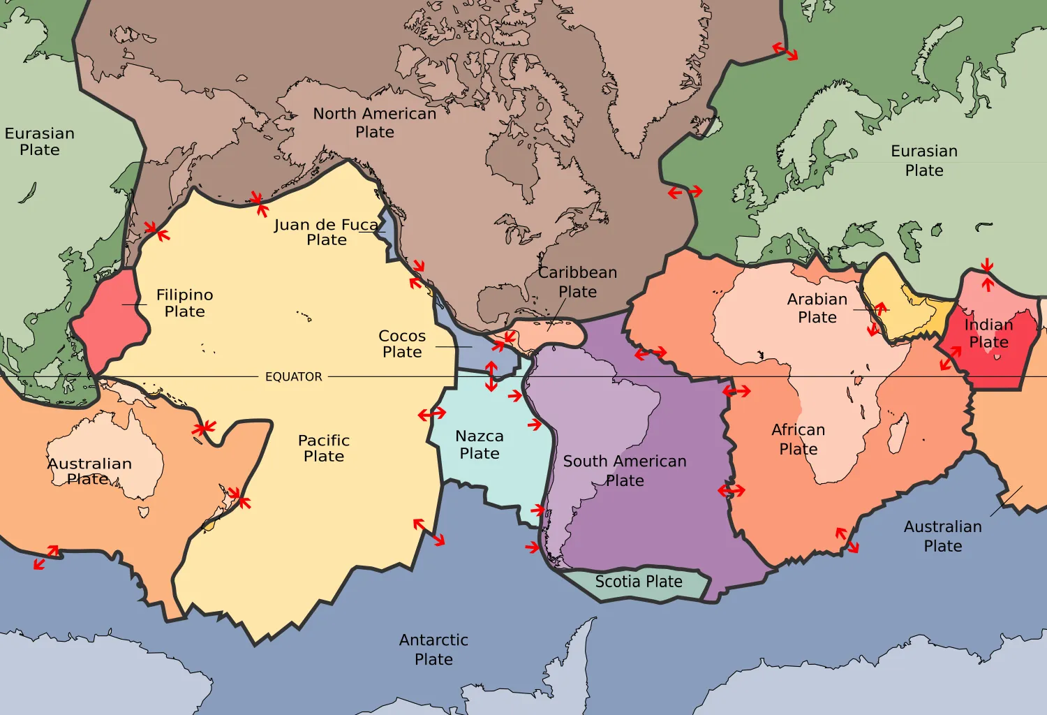
Plates tect2 en

"Plates tect" by Map: USGS Description: Scott Nash/ Wikimedia Commons.

Earth's outer shell is broken into large pieces called tectonic plates. These plates fit together like a giant jigsaw puzzle covering the entire planet. Scientists identify roughly seven or eight major plates, plus many smaller ones. Together, they form Earth's lithosphere, the rigid outer layer that includes the crust and upper mantle. No gaps exist between these plates.

The largest plate is the Pacific Plate, which covers most of the Pacific Ocean floor. Other major plates include the North American Plate, South American Plate, Eurasian Plate, African Plate, Antarctic Plate, and Indo-Australian Plate. Each plate moves slowly across Earth's surface. Scientists observe that these plates carry different types of crust. Some plates contain mostly oceanic crust, which forms the ocean floor. Others carry continental crust, which makes up the continents.

An important discovery is that tectonic plates do not match up with continents. A single plate often carries both a continent and a large area of ocean floor. The North American Plate provides a clear example of this pattern. This plate includes the entire North American continent. It also extends far into the Atlantic Ocean, carrying a large section of seafloor. The plate boundary lies in the middle of the Atlantic, not at the coastline.

Evidence shows that understanding these major plates helps scientists explain where natural events occur. Earthquakes happen most often at plate boundaries where plates meet. Volcanoes can form at these boundaries too. Mountain ranges may develop where plates collide. Scientists use maps of Earth's major plates to predict where these geological features appear. This knowledge helps communities prepare for natural hazards in their regions.

Interesting Fact: The Pacific Plate is so large that it covers an area greater than all of Earth's continents combined, yet it carries almost no continental landmass.

Comprehension quiz (10 questions)

1. How many major tectonic plates cover Earth's surface?

Three or four large plates
Seven or eight large plates
Twelve large plates
Twenty large plates

2. Which is the largest tectonic plate on Earth?

North American Plate
Eurasian Plate
Pacific Plate
African Plate

3. What does the term 'lithosphere' mean in the passage?

The liquid layer beneath Earth's crust
The rigid outer layer including the crust and upper mantle
The center core of Earth
The atmosphere surrounding Earth

4. What type of crust forms the ocean floor?

Continental crust
Mantle crust
Oceanic crust
Volcanic crust

5. Why is it important that tectonic plates do not match up with continents?

It means plates only carry ocean floor
It shows that a single plate can carry both a continent and ocean floor
It proves that continents cannot move
It means plate boundaries are always at coastlines

6. Where does the North American Plate boundary lie in the Atlantic Ocean?

At the North American coastline
At the European coastline
In the middle of the Atlantic Ocean
At the bottom of the ocean floor

7. Based on the passage, where do earthquakes happen most often?

In the center of tectonic plates
Only on continents
At plate boundaries where plates meet
Only in ocean areas

8. How can understanding Earth's major plates help communities?

It helps them predict weather patterns
It helps them prepare for natural hazards like earthquakes and volcanoes
It helps them find new sources of water
It helps them grow better crops

9. True or False: There are gaps between Earth's tectonic plates.

True
False

10. True or False: The Pacific Plate covers an area greater than all of Earth's continents combined.

True
False
Who it's for

Perfect for the way you teach

Teachers
  • Build comprehension skills
  • Auto-graded quiz
  • Differentiated reading
Parents
  • Read together at home
  • Improve fluency
  • Quiet reading time
Homeschoolers
  • Reading curriculum support
  • Independent practice
  • Track Lexile growth
Topics

Reviews & Ratings

No reviews yet. Be the first to share your experience!

More reading you might love

20 more
Passage
Talus Slopes: Formation and Features - reading educational content
Grades 5–8

Talus Slopes: Formation and Features

science · MS-ESS2-1+2

Free
Passage
Stratigraphic Columns: Decoding Earth’s Geological Layers - reading educational content
Grades 5–8

Stratigraphic Columns: Decoding Earth’s Geological Layers

science · MS-ESS2-2+2

Free
Passage
Frost Wedging: How Ice Splits Rock - reading educational content
Grades 5–8

Frost Wedging: How Ice Splits Rock

earth and space science · MS-ESS2-1+2

$1.50
Passage
Chemical Weathering: The Breakdown of Rocks Through Chemical Reactions - reading educational content
Grades 5–8

Chemical Weathering: The Breakdown of Rocks Through Chemical Reactions

earth and space science · MS-ESS2-1+2

Free
Passage
What Is Space Weather and How Does It Affect the Earth? - reading educational content
Grades 3–7

What Is Space Weather and How Does It Affect the Earth?

earth and space science · MS-ESS2-2

$1.50
Passage
When Was The Last Ice Age - reading educational content
Grade 6

When Was The Last Ice Age

earth and space science · MS-ESS2-2

$1.50
Passage
Tools and Technology in Earth Science - reading educational content
Grades 5–8

Tools and Technology in Earth Science

science · MS-ESS2-2+4

$1.50
Passage
Maps and Mapping - reading educational content
Grades 5–8

Maps and Mapping

earth and space science · MS-ESS2-2

$1.50
Passage
Latitude and Longitude - reading educational content
Grades 5–8

Latitude and Longitude

earth and space science · MS-ESS2-2

$1.50
Passage
Topographic Maps - reading educational content
Grades 5–8

Topographic Maps

earth and space science · MS-ESS2-2+3

$1.50
Passage
Contour Lines and Elevation - reading educational content
Grades 5–8

Contour Lines and Elevation

earth and space science · MS-ESS2-2+3

$1.50
Passage
Maps and Their Uses - reading educational content
Grades 5–8

Maps and Their Uses

earth and space science · MS-ESS2-2+5

$1.50
Passage
Mountains and Mountain Building - reading educational content
Grades 5–8

Mountains and Mountain Building

earth and space science · MS-ESS2-1+1

$1.50
Passage
Earth's Interior - reading educational content
Grades 5–8

Earth's Interior

earth and space science · MS-ESS2-1+1

$1.50
Passage
Continental Drift Theory - reading educational content
Grades 5–8

Continental Drift Theory

earth and space science · MS-ESS2-2+1

Free
Passage
Seafloor Spreading - reading educational content
Grades 5–8

Seafloor Spreading

science · MS-ESS2-2+1

$1.50
Passage
Theory of Plate Tectonics - reading educational content
Grades 5–8

Theory of Plate Tectonics

earth and space science · MS-ESS2-2

$1.50
Passage
Divergent Plate Boundaries - reading educational content
Grades 5–8

Divergent Plate Boundaries

earth and space science · MS-ESS2-2

$1.50
Passage
Convergent Plate Boundaries - reading educational content
Grades 5–8

Convergent Plate Boundaries

earth and space science · MS-ESS2-2

$1.50
Passage
Transform Plate Boundaries - reading educational content
Grades 5–8

Transform Plate Boundaries

earth and space science · MS-ESS2-2

$1.50
Copyright © 2026 Workybooks Classroom. Made with ♥ in California.