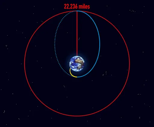
This 400-500 word informational science reading passage introduces middle school students (grades 6-8) to the concept of geostationary orbit, aligned with NGSS standards MS-ESS1.B and MS-ESS1-2. Students explore how satellites positioned approximately 36,000 kilometers above Earth's equator can match the planet's rotation period, appearing to hover over one location. The passage explains orbital mechanics, the relationship between altitude and orbital speed, and real-world applications including weather monitoring and telecommunications. Audio-integrated content supports diverse learners while maintaining scientific accuracy through evidence-based language. Key vocabulary includes geostationary orbit, orbital period, altitude, equator, synchronous, satellite, rotation, and telecommunications. Activities include comprehension questions, writing prompts analyzing cause-effect relationships, and graphic organizers comparing different orbit types. This resource helps students understand how humans use scientific principles to develop technologies that benefit society.
Written by Workybooks TeamPublished by Workybooks
Preview
Sample passage and quiz content
CONTENT PREVIEW
Expand content preview
Geostationary transfer orbit: After liftoff, the launch vehicle makes its way to space following a path shown by the yellow line. "NOAA’s GOES-T Reaches Geostationary Orbit, Now Designated GOES-18 (NESDIS 2022-03-14 goes-18-orbit-1)" by NOAA / Wikimedia Commons (Public domain).
A geostationary orbit is a special path around Earth where a satellite appears to stay in one place above the planet's surface. This happens when the satellite orbits at a precise altitude of approximately 36,000 kilometers above the equator. At this height, the satellite's orbital period matches Earth's rotation period of 24 hours. Scientists explain that this synchronous movement creates the illusion that the satellite hovers motionless over one spot.
The physics behind geostationary orbits involves a balance between gravity and orbital speed. Earth's gravity pulls the satellite inward while the satellite's forward motion keeps it from falling. At 36,000 kilometers, these forces balance perfectly for a 24-hour orbit. Satellites closer to Earth orbit faster and complete their paths in less time. Satellites farther away orbit more slowly and take longer to circle the planet. Evidence shows that only satellites positioned at this specific altitude can remain over the same location.
Weather forecasting agencies use geostationary satellites to monitor storms and track climate patterns continuously. The National Oceanic and Atmospheric Administration operates GOES satellites in geostationary orbit. These satellites can observe the same region of Earth constantly, providing updated images every few minutes. Telecommunications companies also rely on geostationary satellites to transmit television signals and internet data. A single satellite in this orbit can cover about one-third of Earth's surface.
Geostationary orbits matter because they enable technologies that affect daily life. Weather predictions help communities prepare for dangerous storms and extreme conditions. Communication networks connect people across continents for business and personal interactions. Scientists continue to develop new uses for these orbits. Understanding orbital mechanics helps humans design better satellite systems for monitoring Earth and supporting global communications.
Interesting Fact: All geostationary satellites orbit directly above Earth's equator in a ring-shaped path called the Clarke Belt, named after science fiction writer Arthur C. Clarke who first described this concept in 1945.
At what altitude above Earth's equator do geostationary satellites orbit?
Approximately 36,000 kilometersApproximately 3,600 kilometersApproximately 360 kilometersApproximately 360,000 kilometers
How long does it take a geostationary satellite to complete one orbit around Earth?
12 hours24 hours48 hours6 hours
What does the term 'synchronous' mean in the context of geostationary orbits?
Moving at different speedsMoving backward in orbitOccurring at the same time or rateStopping and starting repeatedly
Which organization operates GOES satellites mentioned in the passage?
National Aeronautics and Space AdministrationNational Oceanic and Atmospheric AdministrationFederal Communications CommissionEuropean Space Agency
Why do satellites at 36,000 kilometers altitude appear to hover over one spot on Earth?
They use rocket engines to stay in placeThey are attached to Earth by cablesTheir orbital period matches Earth's rotation periodThey orbit faster than Earth rotates
What happens to satellites that orbit closer to Earth than 36,000 kilometers?
They orbit more slowly and take longer to circle EarthThey orbit faster and complete their paths in less timeThey remain stationary like geostationary satellitesThey fall back to Earth immediately
How much of Earth's surface can one geostationary satellite observe?
About one-half of Earth's surfaceAbout one-quarter of Earth's surfaceAbout one-third of Earth's surfaceThe entire Earth's surface
What two main applications of geostationary satellites are described in the passage?
Navigation and military surveillanceWeather monitoring and telecommunicationsScientific research and space explorationMapping and photography
True or False: All geostationary satellites orbit directly above Earth's equator.
TrueFalse
True or False: Arthur C. Clarke first described the concept of geostationary orbit in 1995.